Preparations for Next Moonwalk Simulations Underway (and Underwater)
NASA’s broadcast of the April 8, 2024, total solar eclipse has won an Emmy Award for Excellence in Production Technology.
At the 76th Technology & Engineering Emmy Awards on Dec. 4, in New York City, the Academy of Television Arts & Sciences announced the win. Walt Lindblom and Sami Aziz accepted the award on behalf of the agency. For the broadcast, Lindblom served as the coordinating producer and Aziz served as the executive producer.
“By broadcasting the total solar eclipse, this team brought joy and wonder for our Sun, Moon, and Earth to viewers across America and the world,” said Will Boyington, associate administrator for the Office of Communications at NASA Headquarters in Washington. “Congratulations to the production team, whose efforts demonstrate the hard work and dedication to the sharing the marvel that makes our solar system something we strive to understand.”
NASA’s live broadcast coverage of the 2024 total solar eclipse was the most complex live project ever produced by the agency. In total, NASA’s eclipse broadcasts garnered almost 40 million live and replay views across its own distribution channels, including on NASA+, the agency’s free streaming service. Externally, the agency’s main broadcast was picked up in 2,208 hits on 568 channels in 25 countries.
“Our unique place in the solar system allows us on Earth to witness one of the most spectacular science shows nature has to offer. NASA’s production team captured the action every step of the way across the path of totality, including the rare glimpse of the Sun’s corona,” said Nicky Fox, associate administrator for science at NASA Headquarters. “Congratulations to the NASA team for successfully showing the 2024 total solar eclipse through the eyes of NASA for the whole world to experience together.”
The broadcast spanned three hours, showcasing the eclipse across seven American states and two countries. From cities, parks, and stadiums, 11 hosts and correspondents provided on air commentary, interviews, and live coverage. Viewers tuned in from all over the world, including at watch parties in nine locations, from the Austin Public Library to New York’s Times Square. An interactive “Eclipse Board” provided real time data analysis as the Moon’s shadow crossed North America.
Live feeds from astronauts aboard the International Space Station and NASA’s WB-57 high-altitude research aircraft were brought in to provide rare and unique perspectives of the solar event. To make this possible, NASA deployed and enabled 67 cameras, 6 NASA Wide Area Network control rooms, 38 encoders, and 35 decoders. The team coordinated 20 live telescope feeds which represented 12 locations across the path of totality.
NASA’s eclipse broadcast won another Emmy award earlier this year at the 46th Annual News & Documentary Emmy Awards for Outstanding Live News Special. Additionally, the show received an Emmy nomination for Outstanding Show Open or Title Sequence – News. NASA’s eclipse communication and broadcast efforts also won two Webby Awards and two Webby People’s Voice Awards.
On April 8, 2024, North America's last total solar eclipse until 2045 moved across the continent. It made landfall in Mexico, crossed the United States from ...
NASA Selects 2 Instruments for Artemis IV Lunar Surface Science
NASA has selected two science instruments designed for astronauts to deploy on the surface of the Moon during the Artemis IV mission to the lunar south polar region. The instruments will improve our knowledge of the lunar environment to support NASA’s further exploration of the Moon and beyond to Mars.
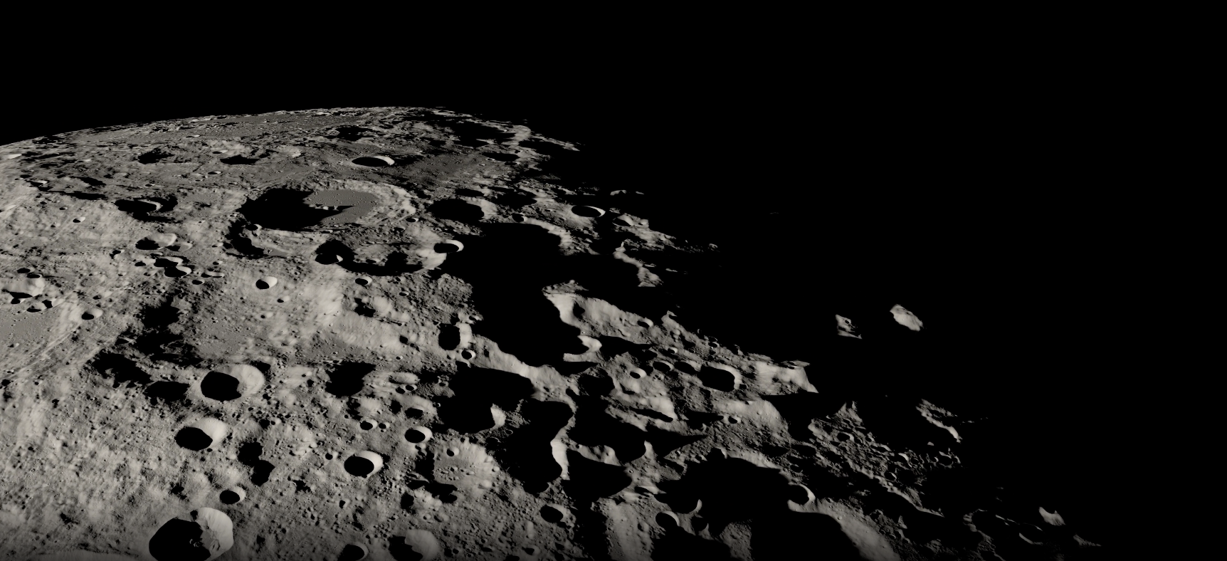
A visualization of the Moon’s South Pole region created with data from NASA’s Lunar Reconnaissance Orbiter, which has been surveying the Moon with seven instruments since 2009.
“The Apollo Era taught us that the further humanity is from Earth, the more dependent we are on science to protect and sustain human life on other planets,” said Nicky Fox, associate administrator, Science Mission Directorate at NASA Headquarters in Washington. “By deploying these two science instruments on the lunar surface, our proving ground, NASA is leading the world in the creation of humanity’s interplanetary survival guide to ensure the health and safety of our spacecraft and human explorers as we begin our epic journey back to the Moon and onward to Mars.”
After his voyage to the Moon’s surface during Apollo 17, astronaut Gene Cernan acknowledged the challenge that lunar dust presents to long-term lunar exploration. Moon dust sticks to everything it touches and is very abrasive. The knowledge gained from the DUSTER (DUst and plaSma environmenT survEyoR) investigation will help mitigate hazards to human health and exploration. Consisting of a set of instruments mounted on a small autonomous rover, DUSTER will characterize dust and plasma around the landing site. These measurements will advance understanding of the Moon’s natural dust and plasma environment and how that environment responds to the human presence, including any disturbance during crew exploration activities and lander liftoff. The DUSTER instrument suite is led by Xu Wang of the University of Colorado Boulder. The contract is for $24.8 million over a period of three years.
A model of the DUSTER instrument suite consisting of the Electrostatic Dust Analyzer (EDA)—which will measure the charge, velocity, size, and flux of dust particles lofted from the lunar surface—and Relaxation SOunder and differentiaL VoltagE (RESOLVE)—which will characterize the average electron density above the lunar surface using plasma sounding. Both instruments will be housed on a Mobile Autonomous Prospecting Platform (MAPP) rover, which will be supplied by Lunar Outpost, a company based in Golden, Colorado, that develops and operates robotic systems for space exploration.
LASP/CU Boulder/Lunar Outpost
Data from the SPSS (South Pole Seismic Station) will enable scientists to characterize the lunar interior structure to better understand the geologic processes that affect planetary bodies. The seismometer will help determine the current rate at which the Moon is struck by meteorite impacts, monitor the real-time seismic environment and how it can affect operations for astronauts, and determine properties of the Moon’s deep interior. The crew will additionally perform an active-source experiment using a “thumper” that creates seismic energy to survey the shallow structure around the landing site. The SPSS instrument is led by Mark Panning of NASA’s Jet Propulsion Laboratory in Southern California. The award is for $25 million over a period of three years.
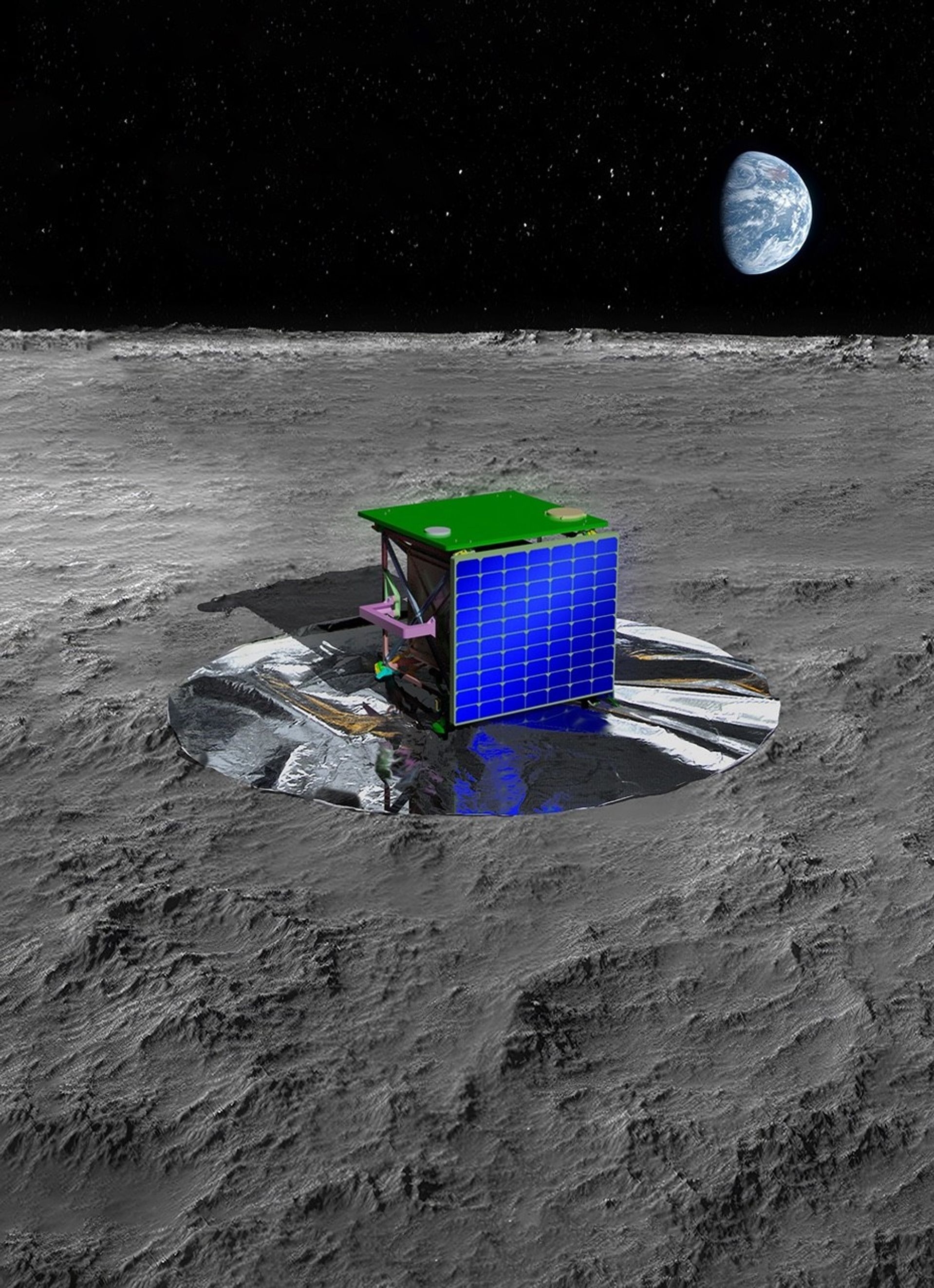
An artist’s concept of SPSS (South Pole Seismic Station) to be deployed by astronauts on the lunar surface.
NASA/JPL-Caltech
“These two scientific investigations will be emplaced by human explorers on the Moon to achieve science goals that have been identified as strategically important by both NASA and the larger scientific community”, said Joel Kearns, deputy associate administrator for exploration, Science Mission Directorate at NASA Headquarters. “We are excited to integrate these instrument teams into the Artemis IV Science Team.”
The two payloads were selected for further development to fly on Artemis IV; however, final manifesting decisions about the mission will be determined at a later date.
Through Artemis, NASA will address high priority science questions, focusing on those that are best accomplished by on-site human explorers on and around the Moon and by using the unique attributes of the lunar environment, aided by robotic surface and orbiting systems. The Artemis missions will send astronauts to explore the Moon for scientific discovery, economic benefits, and build the foundation for the first crewed missions to Mars.
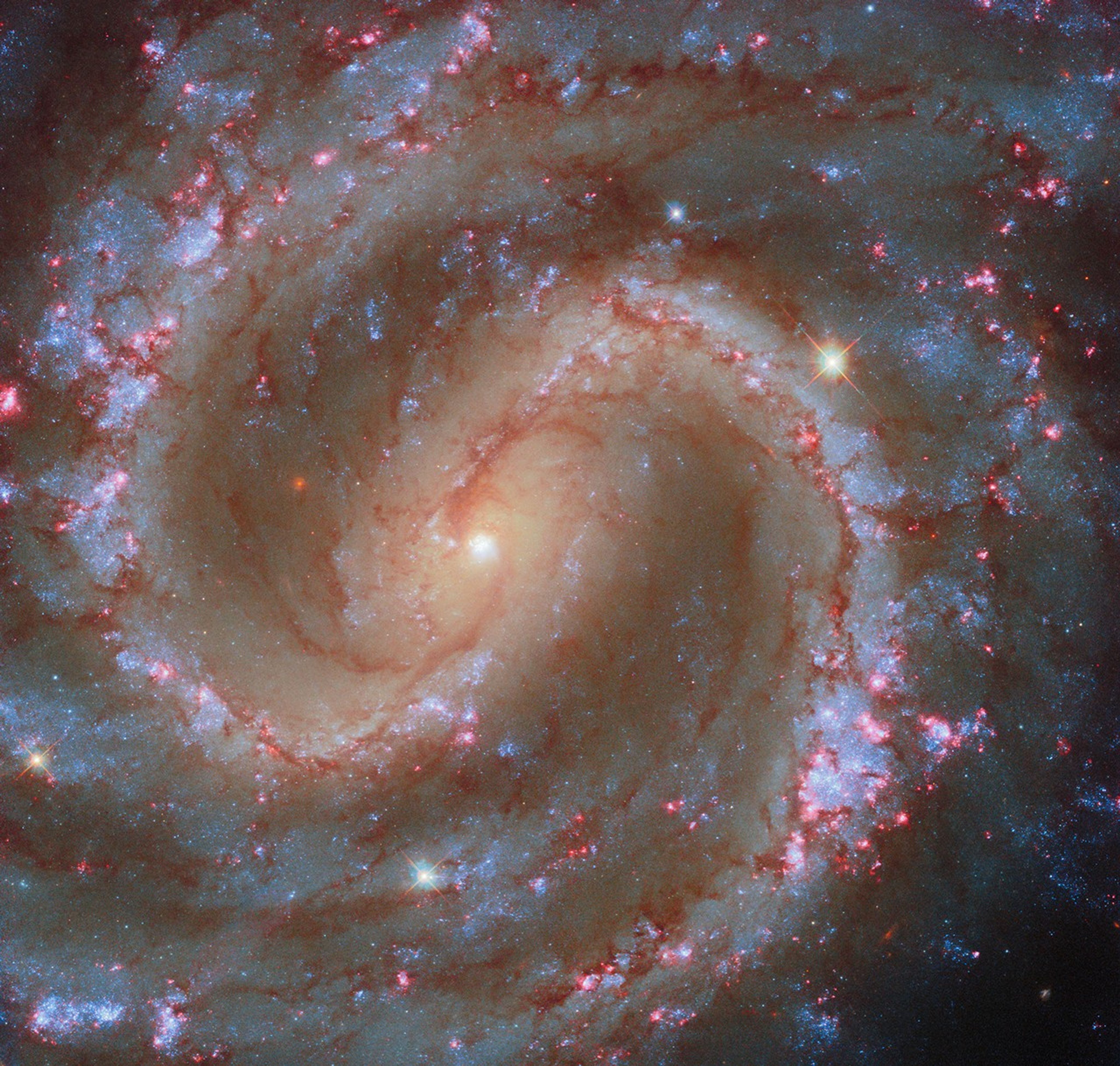
This NASA/ESA Hubble Space Telescope image features the spiral galaxy NGC 4535.
ESA/Hubble & NASA, F. Belfiore, J. Lee and the PHANGS-HST Team
Today’s NASA/ESA Hubble Space Telescope image features the spiral galaxy NGC 4535, which is situated about 50 million light-years away in the constellation Virgo (the Maiden). Through a small telescope, this galaxy appears extremely faint, giving it the nickname ‘Lost Galaxy’. With a mirror spanning nearly eight feet (2.4 meters) across and its location above Earth’s light-obscuring atmosphere, Hubble can easily observe dim galaxies like NGC 4535 and pick out features like its massive spiral arms and central bar of stars.
This image features NGC 4535’s young star clusters, which dot the galaxy’s spiral arms. Glowing-pink clouds surround many of these bright-blue star groupings. These clouds, called H II (‘H-two’) regions, are a sign that the galaxy is home to especially young, hot, and massive stars that blaze with high-energy radiation. Such massive stars shake up their surroundings by heating their birth clouds with powerful stellar winds, eventually exploding as supernovae.
The image incorporates data from an observing program designed to catalog roughly 50,000 H II regions in nearby star-forming galaxies like NGC 4535. Hubble released a previous image of NGC 4535 in 2021. Both the 2021 image and this new image incorporate observations from the PHANGS observing program, which seeks to understand the connections between young stars and cold gas. Today’s image adds a new dimension to our understanding of NGC 4535 by capturing the brilliant red glow of the nebulae that encircle massive stars in their first few million years of life.
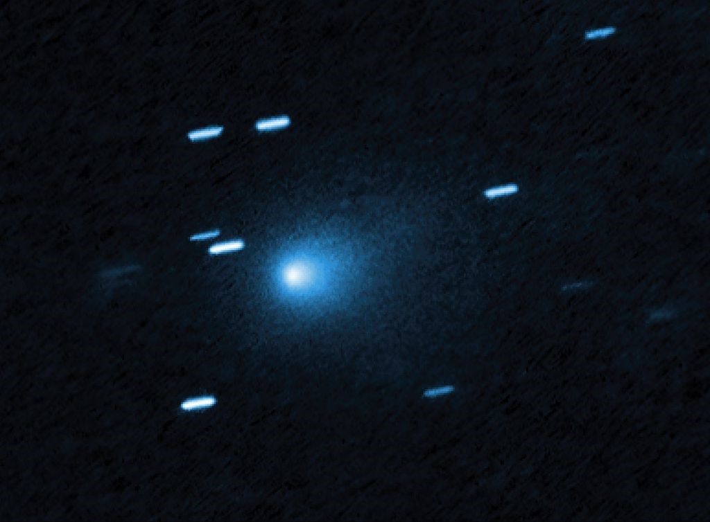
El telescopio espacial Hubble captó esta imagen del cometa interestelar 3I/ATLAS el 21 de julio de 2025, cuando el cometa se encontraba a 445 millones de kilómetros (277 millones de millas) de la Tierra. Hubble muestra que el cometa tiene una envoltura de polvo en forma de lágrima que se desprende de su núcleo sólido y helado.
Crédito: NASA, ESA, David Jewitt (UCLA); Procesamiento de imágenes: Joseph DePasquale (STScI)
La NASA ofrecerá un evento en vivo (en inglés) a las 3 p.m. EST del miércoles 19 de noviembre para compartir imágenes del cometa interestelar 3I/ATLAS captadas por varias misiones de la agencia. El evento tendrá lugar en el Centro de Vuelo Espacial Goddard de la NASA, en Greenbelt, Maryland.
El cometa 3I/ATLAS, descubierto el 1 de julio por el observatorio ATLAS (por las siglas en inglés de Sistema de Última Alerta de Impacto Terrestre de Asteroides), financiado por la NASA. El cometa es el tercer objeto identificado hasta la fecha que ha entrado en nuestro sistema solar procedente de otra parte de la galaxia. Aunque no supone ninguna amenaza para la Tierra y no se acercará a menos de 273 millones de kilómetros (170 millones de millas) de nuestro planeta, el cometa pasó a menos de 30 millones de kilómetros (19 millones de millas) de Marte a principios de octubre.
El evento se retransmitirá en NASA+, la aplicación de la NASA, el sitio web y el canal de YouTube de la agencia, y Amazon Prime.
Entre los participantes en la sesión informativa, que proceden de la sede central de la NASA en Washington, se encuentran:
Amit Kshatriya, administrador asociado de la NASA
Nicky Fox, administradora asociada, Dirección de Misiones Científicas
Shawn Domagal-Goldman, director interino, División de Astrofísica
Tom Statler, científico jefe para cuerpos pequeños del sistema solar.
Para participar virtualmente en el evento NASA Live, los miembros de los medios de comunicación deben enviar su nombre completo, afiliación mediática, dirección de correo electrónico y número de teléfono a más tardar dos horas antes del inicio del evento a Molly Wasser: molly.l.wasser@nasa.gov. Los miembros del público también podrán hacer preguntas utilizando #AskNASA en las redes sociales, y sus preguntas podrían ser respondidas, en inglés y en tiempo real, durante la transmisión. También contamos con un experto en la materia con disponibilidad limitada para entrevistas de seguimiento en español. Para solicitar una entrevista en español, póngase en contacto con María José Viñas: maria-jose.vinasgarcia@nasa.gov
Recursos de misiones científicas de la NASA proporcionan a Estados Unidos la capacidad única de observar a 3I/ATLAS prácticamente durante todo el tiempo que permanecerá en nuestra vecindad celeste y estudiar, con instrumentos científicos complementarios y desde diferentes direcciones, cómo se comporta el cometa. Estos instrumentos incluyen tanto naves espaciales en todo el sistema solar como observatorios terrestres.
Hubble captured this image of the interstellar comet 3I/ATLAS on July 21, 2025, when the comet was 277 million miles from Earth. Hubble shows that the comet has a teardrop-shaped cocoon of dust coming off its solid, icy nucleus.
Credit: NASA, ESA, David Jewitt (UCLA); Image Processing: Joseph DePasquale (STScI)
NASA will host a live event at 3 p.m. EST, Wednesday, Nov. 19, to share imagery of the interstellar comet 3I/ATLAS collected by a number of the agency’s missions. The event will take place at NASA’s Goddard Space Flight Center in Greenbelt, Maryland.
Comet 3I/ATLAS, discovered by the NASA-funded ATLAS (Asteroid Terrestrial-impact Last Alert System) observatory on July 1, is only the third object ever identified as entering our solar system from elsewhere in the galaxy. While it poses no threat to Earth and will get no closer than 170 million miles to Earth, the comet flew within 19 million miles of Mars in early October.
The event will air on NASA+, the NASA app, the agency’s website and YouTube channel, and Amazon Prime.
Tom Statler, lead scientist for solar system small bodies
To participate virtually in the NASA Live event, members of the media must send their full name, media affiliation, email address, and phone number no later than two hours before the start of the event to Molly Wasser at: molly.l.wasser@nasa.gov. Members of the public also may ask questions, which may be answered in real time during the broadcast, by using #AskNASA on social media.
Assets within NASA’s science missions give the United States the unique capability to observe 3I/ATLAS almost the entire time it passes through our celestial neighborhood, and study – with complementary scientific instruments and from different directions – how the comet behaves. These assets include both spacecraft across the solar system, as well as ground-based observatories.
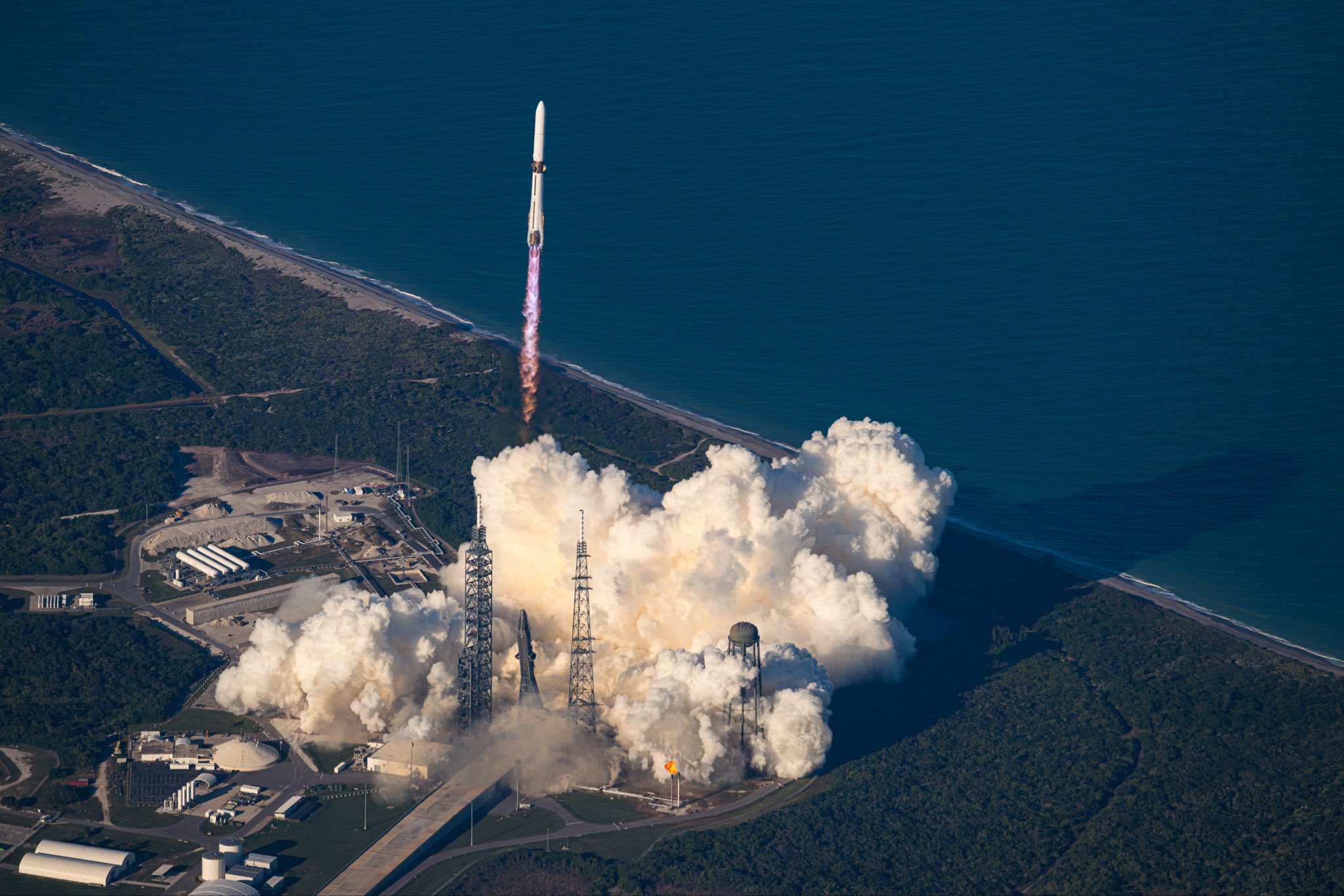
The Sentinel-6B satellite lifted off aboard a SpaceX Falcon 9 rocket from Launch Complex 4 East at Vandenberg Space Force Base in central California at 9:21 p.m. PST on Nov. 16.
Credit: NASA/Carla Thomas
About the size of a full-size pickup truck, a newly launched satellite by NASA and its partners will provide ocean and atmospheric information to improve hurricane forecasts, help protect infrastructure, and benefit commercial activities, such as shipping.
The Sentinel-6B satellite lifted off aboard a SpaceX Falcon 9 rocket from Launch Complex 4 East at Vandenberg Space Force Base in central California at 9:21 p.m. PST on Nov. 16. Contact between the satellite and a ground station in northern Canada occurred about 1 hour and 30 minutes later at 10:54 p.m. All systems are functioning normally.
“Understanding tidal patterns down to the inch is critical in protecting how we use our oceans every day on Earth,” said Nicky Fox, associate administrator, Science Mission Directorate at NASA Headquarters in Washington. “Sentinel-6B will build upon the legacy of Sentinel-6 Michael Freilich by making sea level measurements that improve forecasts used by communities, businesses, and operations across the country. It also will support a safer reentry for our astronauts returning home, including crew from Artemis Moon missions.”
Sea levels vary from place to place, and the satellite will provide accurate measurements at both local and global scales — all from hundreds of miles above in low Earth orbit. Those observations form the basis for U.S. flood predictions, which are crucial for safeguarding coastal infrastructure, real estate, energy storage sites, and other coastal assets. Sentinel-6B will take over for Sentinel-6 Michael Freilich, which launched in 2020 and later became the official reference satellite for global sea level measurements, providing sea surface height measurements against which those from other satellites are compared for accuracy.
The satellite comes from a collaboration between multiple partners, including NASA, ESA (European Space Agency), EUMETSAT (European Organisation for the Exploitation of Meteorological Satellites), and the National Oceanic and Atmospheric Administration (NOAA). It also is part of the European Union’s family of Copernicus missions.
“Collaboration between partners is key to a mission such as Sentinel-6, and my thanks go to everyone involved in developing, launching, and operating this exceptional satellite, which follows in the footsteps of the first Sentinel-6, Michael Freilich,” said Simonetta Cheli, director, ESA’s Earth Observation Programmes. “This achievement demonstrates what can be accomplished when international agencies and industries work together toward a shared goal. Sentinel-6B will ensure we continue to collect the high-precision data needed to understand our changing climate, safeguard our oceans and support decisions that protect coastal communities around the world.”
The two satellites make up the Copernicus Sentinel-6/Jason-CS (Continuity of Service) mission, the latest in a series of ocean-observing radar altimetry missions that have monitored Earth’s changing seas since the early 1990s.
As with its predecessor, Sentinel-6B satellite also will provide key information about wind speeds, wave heights, atmospheric temperature, and humidity. Moreover, because water expands as its temperature increases, researchers can tell which parts of the ocean are warmer than others based on where the sea surface height is greater.
Combined with data from other instruments, that knowledge can help in forecasting marine weather, including the development of hurricanes, which intensify with warmer water. Also, because large currents are taller than surrounding waters due to their higher temperatures, sea surface measurements can shed light on interactions between the Gulf Stream, for example, and nearby waves. Where they meet, seas can become rougher, presenting a hazard to even the largest ships.
“Sentinel-6B is a testament to the value of NASA’s partnership missions to put actionable satellite information and science into the hands of decision-makers on the ground,” said Karen St. Germain, director, NASA Earth Science Division at the agency’s headquarters. “Sentinel-6B will collect ocean surface observations that will inform decisions critical to coastal communities, commercial shipping and fishing, national defense, and emergency preparedness and response. This is what NASA does — puts advanced technology and science into action for the benefit of the nation.”
When Sentinel-6B reaches its operating elevation, the satellite will fly about 30 seconds behind Sentinel-6 Michael Freilich, which carries identical science instruments. Once the mission finishes cross-calibrating the data collected by the two, Sentinel-6 Michael Freilich will move into a different orbit, and Sentinel-6B will take over the role of official reference satellite, orbiting Earth about 13 times a day at 830 miles (1,336 kilometers) above the surface.
“Sentinel-6B demonstrates the versatile Earth science applications made possible by expertly engineered, space-based technology. The satellite’s powerful suite of instruments will measure about 90% of Earth’s oceans down to fractions of an inch — continuing to add to a vital dataset that America and a growing global community depend on,” said Dave Gallagher, director, NASA’s Jet Propulsion Laboratory (JPL) in Southern California.
More about Sentinel-6B
Copernicus Sentinel-6/Jason-CS is a collaboration between ESA, the European Union, EUMETSAT, NASA, and NOAA. French space agency CNES (Centre National d’Études Spatiales) contributed technical support. Copernicus, which includes the Sentinel missions, is the European Union’s Earth observation program led by the European Commission.
A division of Caltech in Pasadena, JPL contributed three science instruments for each Sentinel-6 satellite: the Advanced Microwave Radiometer, the Global Navigation Satellite System – Radio Occultation, and the laser retroreflector array. NASA also is contributing launch services, ground systems supporting operation of the NASA science instruments, the science data processors for two of these instruments, and support for the U.S. members of the international Ocean Surface Topography Science Team, and Sentinel-6 science teams.
In this artist’s concept, the ocean-observing satellite Sentinel-6B orbits Earth with its deployable solar panels extended.
Credit: NASA/JPL-Caltech
NASA will provide live coverage of prelaunch and launch activities for Sentinel-6B, an international mission delivering critical sea level and ocean data to protect coastal infrastructure, improve weather forecasting, and support commercial activities at sea.
Launch is targeted at 12:21 a.m. EST, Monday, Nov. 17 (9:21 p.m. PST, Sunday, Nov. 16) aboard a SpaceX Falcon 9 rocket from Space Launch Complex 4 East at Vandenberg Space Force Base in California.
Watch coverage beginning at 11:30 p.m. EST (8:30 p.m. PST) on NASA+, Amazon Prime, and more. Learn how to watch NASA content through a variety of platforms, including social media.
The Sentinel-6B mission continues a decades-long effort to monitor global sea level and ocean conditions using precise radar measurements from space. Since the early 1990s, satellites launched by NASA and domestic and international partners have collected precise sea level data. The launch of Sentinel-6B will extend this dataset out to nearly four decades.
NASA’s mission coverage is as follows (all times Eastern and subject to change based on real-time operations):
Saturday, Nov. 15
4 p.m. – NASA Prelaunch Teleconference on International Ocean Tracking Mission
Karen St. Germain, director, Earth Science Division, NASA Headquarters in Washington
Pierrik Veuilleumier, Sentinel-6B project manager, ESA (European Space Agency)
Parag Vaze, Sentinel-6B project manager, NASA’s Jet Propulsion Laboratory in Pasadena, California
Tim Dunn, senior launch director, Launch Services Program, NASA’s Kennedy Space Center in Florida
Julianna Scheiman, director, NASA Science Missions, SpaceX
1st Lt. William Harbin, launch weather officer, U.S. Air Force
11:30 p.m. – Launch coverage begins on NASA+, Amazon Prime, and more.
Audio-only coverage
Audio-only of the launch coverage will be carried on the NASA “V” circuits, which may be accessed by dialing 321-867-1220 or -1240. On launch day, “mission audio” countdown activities without NASA+ launch commentary will be carried at 321-867-7135.
NASA website launch coverage
Launch day coverage of the mission will be available on the agency’s website. Coverage will include links to live streaming and blog updates beginning no earlier than 11 p.m. EST, Nov. 16, as the countdown milestones occur. Streaming video and photos of the launch will be accessible on demand shortly after liftoff. Follow countdown coverage on NASA’s Sentinel-6/Jason-CS blog.
For questions about countdown coverage, contact the NASA Kennedy newsroom at: 321-867-2468.
Attend launch virtually
Members of the public can register to attend this launch virtually. NASA’s virtual guest program for this mission includes curated launch resources, notifications about related opportunities or changes, and a stamp for the NASA virtual guest passport following launch.
Watch, engage on social media
Let people know you’re watching the mission on X, Facebook, and Instagram by following and tagging these accounts:
Sentinel-6B is the second of twin satellites in the Copernicus Sentinel-6/Jason-CS (Continuity of Service) mission, a collaboration among NASA, ESA, EUMETSAT (European Organisation for the Exploitation of Meteorological Satellites), and the National Oceanic and Atmospheric Administration (NOAA). The first satellite in the mission, Sentinel-6 Michael Freilich, launched in November 2020. The European Commission contributed funding support, while France’s space agency CNES (Centre National d’Études Spatiales) provided technical expertise. The mission also marks the first international involvement in Copernicus, the European Union’s Earth Observation Programme.
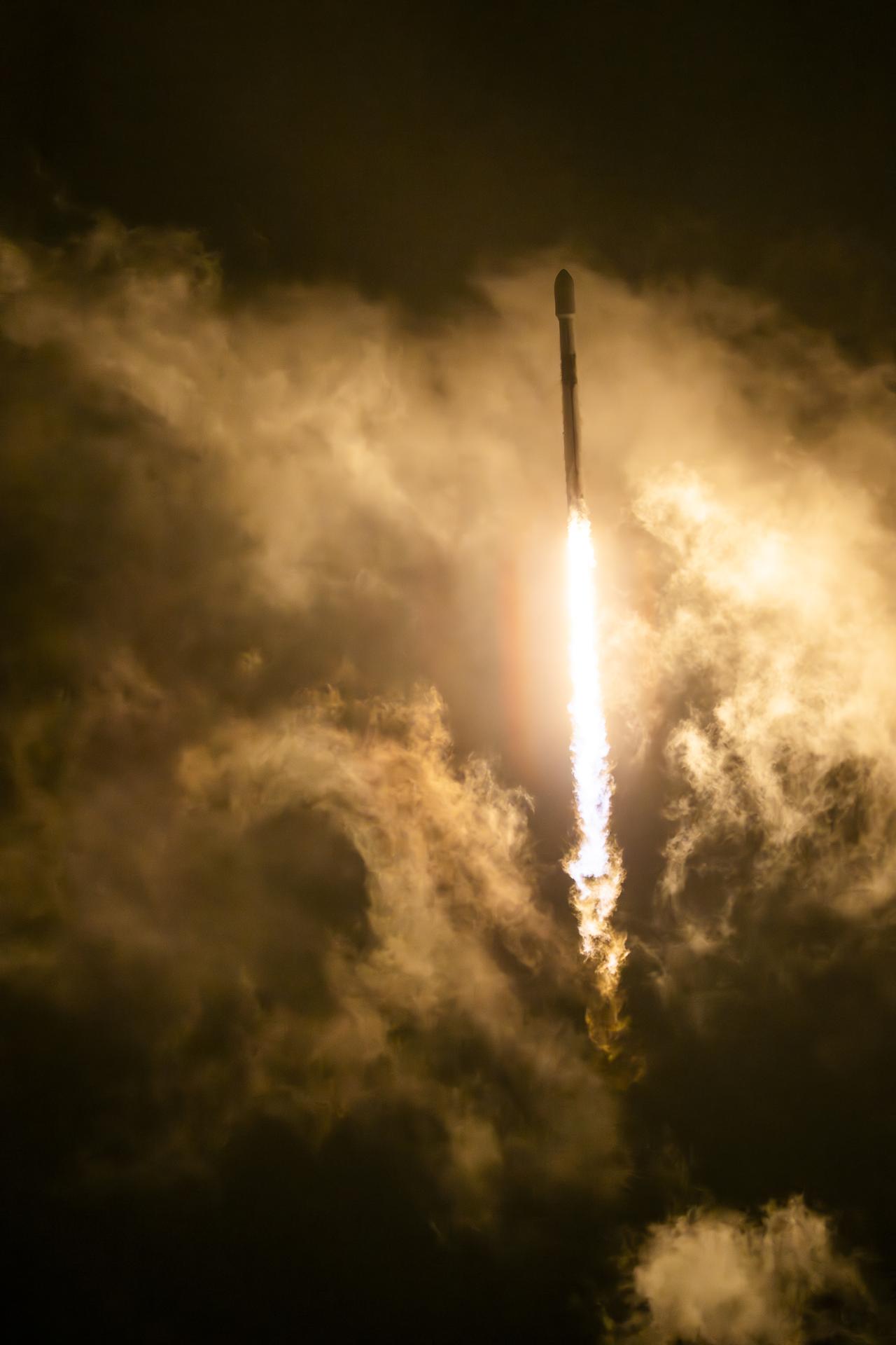
NASA’s ESCAPADE (Escape and Plasma Acceleration and Dynamics Explorers) mission launched at 3:55 p.m. EST atop a Blue Origin New Glenn rocket at Launch Complex 36 at Cape Canaveral Space Force Station in Florida.
Credit: Blue Origin
A pair of NASA spacecraft ultimately destined for Mars will study how its magnetic environment is impacted by the Sun. The mission also will help the agency prepare for future human exploration of Mars.
NASA’s ESCAPADE (Escape and Plasma Acceleration and Dynamics Explorers) spacecraft launched at 3:55 p.m. EST, Thursday, aboard a Blue Origin New Glenn rocket from Launch Complex 36 at Cape Canaveral Space Force Station in Florida.
“Congratulations to Blue Origin, Rocket Lab, UC Berkeley, and all our partners on the successful launch of ESCAPADE. This heliophysics mission will help reveal how Mars became a desert planet, and how solar eruptions affect the Martian surface,” said acting NASA Administrator Sean Duffy. “Every launch of New Glenn provides data that will be essential when we launch MK-1 through Artemis. All this information will be critical to protect future NASA explorers and invaluable as we evaluate how to deliver on President Trump’s vision of planting the Stars and Stripes on Mars.”
The twin spacecraft, built by Rocket Lab, will investigate how a never-ending, million-mile-per-hour stream of particles from the Sun, known as the solar wind, has gradually stripped away much of the Martian atmosphere, causing the planet to cool and its surface water to evaporate. The mission is led by the University of California, Berkeley.
Ground controllers for the ESCAPADE mission established communications with both spacecraft by 10:35 p.m. EST.
“The ESCAPADE mission is part of our strategy to understand Mars’ past and present so we can send the first astronauts there safely,” said Nicky Fox, associate administrator, Science Mission Directorate at NASA Headquarters in Washington. “Understanding Martian space weather is a top priority for future missions because it helps us protect systems, robots, and most importantly, humans, in extreme environments.”
New Glenn also carried a space communications technology demonstration from Viasat Inc., supporting NASA’s efforts to commercialize next-generation satellite relay services for science missions. Funded by the agency’s Communications Services Project, the demonstration transmitted launch telemetry data from the rocket’s second stage to an operations center on Earth through Viasat’s geostationary satellite network.
Blazing new trails
Recent solar activity, which triggered widespread auroras on Earth, caused a slight delay in launch to prevent solar storms from negatively impacting post-launch spacecraft commissioning. When ESCAPADE arrives at Mars, it will study present-day effects of the solar wind and solar storms on the Red Planet in real time. This will provide insights about Martian space weather and help NASA better understand the conditions astronauts will face when they reach Mars.
“The ESCAPADE spacecraft are now about to embark on a unique journey to Mars never traversed by any other mission,” said Alan Zide, ESCAPADE program executive at NASA Headquarters.
Rather than heading directly to Mars, the twin spacecraft will first head to a location in space a million miles from Earth called Lagrange point 2. Right now, Earth and Mars are on opposite sides of the Sun, which makes it harder to travel from one planet to the other. In November 2026, when Earth and Mars are closely aligned in their orbits, the ESCAPADE spacecraft will loop back to Earth and use Earth’s gravity to slingshot themselves toward Mars.
In the past, Mars missions have waited to launch during a brief window of time when Earth and Mars are aligned, which happens roughly every two years. However, with the type of trajectory ESCAPADE is using, future missions could launch nearly anytime and wait in space, queueing up for their interplanetary departure, until the two planets are in position.
This original “Earth-proximity” or “loiter” orbit also will make ESCAPADE the first mission to ever pass through a distant region of Earth’s magnetotail, part of our planet’s magnetic field that gets stretched out away from the Sun by the solar wind.
Studying Mars in stereo
After a 10-month cruise, ESCAPADE is expected to arrive at Mars in September 2027, becoming the first coordinated dual-spacecraft mission to enter orbit around another planet.
Over several months, the two spacecraft will arrange themselves in their initial science formation, in which the twin spacecraft will follow each other in the same “string-of-pearls” orbit, passing through the same areas in quick succession to investigate for the first time how space weather conditions vary on short timescales. This science campaign will begin in June 2028.
Six months later, both spacecraft will shift into different orbits, with one traveling farther from Mars and the other staying closer to it. Planned to last for five months, this second formation aims to study the solar wind and Mars’ upper atmosphere simultaneously, allowing scientists to investigate how the planet responds to the solar wind in real time.
In addition, ESCAPADE will provide more information about Mars’ ionosphere — a part of the upper atmosphere that future astronauts will rely on to send radio and navigation signals around the planet.
The ESCAPADE mission is funded by NASA’s Heliophysics Division and is part of NASA’s Small Innovative Missions for Planetary Exploration program. NASA’s Goddard Space Flight Center in Greenbelt, Maryland, Embry-Riddle Aeronautical University, and Advanced Space support the mission. NASA’s Launch Services Program, based at Kennedy Space Center in Florida, secured the launch service with Blue Origin under the Venture-class Acquisition of Dedicated and Rideshare contract.
NASA’s new ESCAPADE mission is launching to Mars to help us better understand the Sun’s influence on Mars’ past and present. Its work could help protect futu...
Preparations for Next Moonwalk Simulations Underway (and Underwater)
Recent airborne science flights to Greenland are improving NASA’s understanding of space weather by measuring radiation exposure to air travelers and validating global radiation maps used in flight path planning. This unique data also has value beyond the Earth as a celestial roadmap for using the same instrumentation to monitor radiation levels for travelers entering Mars’ atmosphere and for upcoming lunar exploration.
NASA’s Space Weather Aviation Radiation (SWXRAD) aircraft flight campaign took place August 25-28 and conducted two five-hour flights in Nuuk, Greenland. Based out of NASA’s Langley Research Center in Hampton, Virginia, the mission gathered dosimetry measurements, or the radiation dose level, to air travelers from cosmic radiation. Cosmic radiation is caused by high-energy particles from outer space that originate from our Sun during eruptive events like solar flares and from events farther away, like supernovae in our Milky Way galaxy and beyond.
Science team partners from Honeywell reviewing dosimeter data on board NASA’s B200 King Air during a flight over Nuuk, Greenland.
NASA/Guillaume Gronoff
“With NASA spacecraft and astronauts exploring the Moon, Mars, and beyond, we support critical research to understand – and ultimately predict – the impacts of space weather across the solar system,” said Jamie Favors, director of NASA’s Space Weather Program at NASA Headquarters in Washington. “Though this project is focused on aviation applications on Earth, NAIRAS could be part of the next generation of tools supporting Artemis missions to the Moon and eventually human missions to Mars.”
Jamie Favors, NASA Space Weather Program director, and Chris Mertens, SWXRAD principal investigator, discussing a dosimeter at NASA’s Langley Research Center as specialized instruments are integrated onto NASA’s B200 King Air aircraft before deploying to Greenland.
NASA/Mark Knopp
NASA’s Nowcast of Aerospace Ionizing Radiation System, or NAIRAS, is the modeling system being enhanced by the SWXRAD airborne science flights. The model features real-time global maps of the hazardous radiation in the atmosphere and creates exposure predictions for aircraft and spacecraft.
NASA’s B200 King Air on the runway in Goose Bay, Canada, a stop during the flight to Nuuk, Greenland.
NASA/Guillaume Gronoff
“The radiation exposure is maximum at the poles and minimum at the equator because of the effect of Earth’s magnetic field. In the polar regions, the magnetic field lines are directed into or out of the Earth, so there’s no deflection or shielding by the fields of the radiation environment that you see everywhere else.” explained Chris Mertens, principal investigator of SWXRAD at NASA Langley. “Greenland is a region where the shielding of cosmic radiation by Earth’s magnetic field is zero.”
That means flight crews and travelers on polar flights from the U.S. to Asia or from the U.S. to Europe are exposed to higher levels of radiation.
Frozen and rocky terrain in the Polar region observed from above Nuuk, Greenland during NASA’s SWXRAD science flights.
NASA/Guillaume Gronoff
The data gathered in Greenland will be compared to the NAIRAS modeling, which bases its computation on sources around the globe that include neutron monitors and instruments that measure solar wind parameters and the magnetic field along with spaceborne data from instruments like the NOAA GOES series of satellites.
“If the new data doesn’t agree, we have to go back and look at why that is,” said Mertens. “In the radiation environment, one of the biggest uncertainties is the effect of Earth’s magnetic field. So, this mission eliminates that variable in the model and enables us to concentrate on other areas, like characterizing the particles that are coming in from space into the atmosphere, and then the transport and interactions with the atmosphere.”
An aerial view of Nuuk, Greenland.
NASA/Guillaume Gronoff
The SWXRAD science team flew aboard NASA’s B200 King Air with five researchers and crew members. In the coming months, the team will focus on measurement data quality checks, quantitative modeling comparisons, and a validation study between current NAIRAS data and the new aircraft dosimeter measurements.
All of this information is endeavoring to protect pilots and passengers on Earth from the health risks associated with radiation exposure while using NASA’s existing science capabilities to safely bring astronauts to the Moon and Mars.
Northern Lights, or auroras, seen over the city of Nuuk, Greenland. Auroras are considered space weather and are easily visible effects of activity from the Sun interacting with the magnetosphere and Earth’s atmosphere.
NASA/Guillaume Gronoff
“Once you get to Mars and even the transit out to Mars, there would be times where we don’t have any data sets to really understand what the environment is out there,” said Favors. “So we’re starting to think about not only how do we get ready for those humans on Mars, but also what data do we need to bring with them? So we’re feeding this data into models exactly like NAIRAS. This model is thinking about Mars in the same way it’s thinking about Earth.”
The SWXRAD flight mission is funded through NASA’s Science Mission Directorate Heliophysics Division. NASA’s Space Weather Program Office is hosted at NASA Langley and facilitates researchers in the creation of new tools to predict space weather and to understand space weather effects on Earth’s infrastructure, technology, and society.
For more information on NASA Heliophysics and NAIRAS modeling visit:
Captured on Aug. 21, this image from NISAR’s L-band radar shows Maine’s Mount Desert Island. Green indicates forest; magenta represents hard or regular surfaces, like bare ground and buildings. The magenta area on the island’s northeast end is the town of Bar Harbor.
Credit: NASA/JPL-Caltech
The NISAR (NASA-ISRO Synthetic Aperture Radar) Earth-observing radar satellite’s first images of our planet’s surface are in, and they offer a glimpse of things to come as the joint mission between NASA and ISRO (Indian Space Research Organisation) approaches full science operations later this year.
“Launched under President Trump in conjunction with India, NISAR’s first images are a testament to what can be achieved when we unite around a shared vision of innovation and discovery,” said acting NASA Administrator Sean Duffy. “This is only the beginning. NASA will continue to build upon the incredible scientific advancements of the past and present as we pursue our goal to maintain our nation’s space dominance through Gold Standard Science.”
Images from the spacecraft, which was launched by ISRO on July 30, display the level of detail with which NISAR scans Earth to provide unique, actionable information to decision-makers in a diverse range of areas, including disaster response, infrastructure monitoring, and agricultural management.
“By understanding how our home planet works, we can produce models and analysis of how other planets in our solar system and beyond work as we prepare to send humanity on an epic journey back to the Moon and onward to Mars,” said NASA Associate Administrator Amit Kshatriya. “The successful capture of these first images from NISAR is a remarkable example of how partnership and collaboration between two nations, on opposite sides of the world, can achieve great things together for the benefit of all.”
On Aug. 21, the satellite’s L-band synthetic aperture radar (SAR) system, which was provided by NASA’s Jet Propulsion Laboratory in Southern California, captured Mount Desert Island on the Maine coast. Dark areas represent water, while green areas are forest, and magenta areas are hard or regular surfaces, such as bare ground and buildings. The L-band radar system can resolve objects as small as 15 feet (5 meters), enabling the image to display narrow waterways cutting across the island, as well as the islets dotting the waters around it.
Then, on Aug. 23, the L-band SAR captured data of a portion of northeastern North Dakota straddling Grand Forks and Walsh counties. The image shows forests and wetlands on the banks of the Forest River passing through the center of the frame from west to east and farmland to the north and south. The dark agricultural plots show fallow fields, while the lighter colors represent the presence of pasture or crops, such as soybean and corn. Circular patterns indicate the use of center-pivot irrigation.
On Aug. 23, NISAR imaged land adjacent to northeastern North Dakota’s Forest River. Light-colored wetlands and forests line the river’s banks, while circular and rectangular plots throughout the image appear in shades that indicate the land may be pasture or cropland with corn or soy.
Credit: NASA/JPL-Caltech
The images demonstrate how the L-band SAR can discern what type of land cover — low-lying vegetation, trees, and human structures — is present in each area. This capability is vital both for monitoring the gain and loss of forest and wetland ecosystems, as well as for tracking the progress of crops through growing seasons around the world.
“These initial images are just a preview of the hard-hitting science that NISAR will produce — data and insights that will enable scientists to study Earth’s changing land and ice surfaces in unprecedented detail while equipping decision-makers to respond to natural disasters and other challenges,” said Nicky Fox, associate administrator, Science Mission Directorate at NASA Headquarters in Washington. “They are also a testament to the years of hard work of hundreds of scientists and engineers from both sides of the world to build an observatory with the most advanced radar system ever launched by NASA and ISRO.”
The L-band system uses a 10-inch (25-centimeter) wavelength that enables its signal to penetrate forest canopies and measure soil moisture and motion of ice surfaces and land down to fractions of an inch, which is a key measurement in understanding how the land surface moves before, during, and after earthquakes, volcanic eruptions, and landslides.
The preliminary L-band images are an example of what the mission team will be able to produce when the science phase begins in November. The satellite was raised into its operational 464-mile (747-kilometer) orbit in mid-September.
The NISAR mission also includes an S-band radar, provided by ISRO’s Space Applications Centre, that uses a 4-inch (10-centimeter) microwave signal that is more sensitive to small vegetation, making it effective at monitoring certain types of agriculture and grassland ecosystems.
The spacecraft is the first to carry both L- and S-band radars. The satellite will monitor Earth’s land and ice surfaces twice every 12 days, collecting data using the spacecraft’s drum-shaped antenna reflector, which measures 39 feet (12 meters) wide — the largest NASA has ever sent into space.
The NISAR mission is a partnership between NASA and ISRO spanning years of technical and programmatic collaboration. The successful launch and deployment of NISAR builds on a strong heritage of cooperation between the United States and India in space.
The Space Applications Centre provided the mission’s S-band SAR. The U R Rao Satellite Centre provided the spacecraft bus. The launch vehicle was provided by Vikram Sarabhai Space Centre, and launch services were through Satish Dhawan Space Centre. Key operations, including boom and radar antenna reflector deployment, are now being executed and monitored by the ISRO Telemetry, Tracking and Command Network’s global system of ground stations.
Managed by Caltech in Pasadena, NASA JPL leads the U.S. component of the project. In addition to the L-band SAR, reflector, and boom, JPL also provided the high-rate communication subsystem for science data, a solid-state data recorder, and payload data subsystem. NASA’s Goddard Space Flight Center in Greenbelt, Maryland, manages the Near Space Network, which receives NISAR’s L-band data.
Un cohete Falcon 9 de SpaceX que transporta las misiones Sonda de Cartografía y Aceleración Interestelar (IMAP, por su acrónimo en inglés) y el Observatorio Carruthers de la Geocorona, ambos de la NASA, y la nave espacial de Seguimiento de la Meteorología Espacial en el Punto de Lagrange 1 (SWFO-L1, por sus siglas en inglés) de la NOAA, despega desde el Centro Espacial Kennedy de la NASA en Florida el miércoles 24 de septiembre de 2025.
La NASA y la Administración Nacional Oceánica y Atmosférica (NOAA, por sus siglas en inglés) lanzaron el miércoles tres nuevas misiones para investigar la influencia del Sol en todo el sistema solar.
A las 7:30 a. m. EDT, un cohete Falcon 9 de SpaceX despegó del Complejo de Lanzamiento 39A del Centro Espacial Kennedy de la NASA en Florida, llevando a bordo las misiones Sonda de Cartografía y Aceleración Interestelar (IMAP, por su acrónimo en inglés) y el Observatorio Carruthers de la Geocorona, ambos de la NASA, y la nave espacial de Seguimiento de la Meteorología Espacial en el Punto de Lagrange 1 (SWFO-L1, por sus siglas en inglés) de la NOAA.
“Este exitoso lanzamiento mejora la preparación de nuestro país ante las condiciones meteorológicas espaciales para proteger mejor nuestros satélites, misiones interplanetarias y astronautas que viajan al espacio de los peligros de la meteorología espacial en todo el sistema solar”, afirmó el administrador interino de la NASA, Sean Duffy. “Esta información será fundamental a medida que nos preparamos para futuras misiones a la Luna y Marte con la intención de mantener a Estados Unidos a la vanguardia en el espacio”.
Estas misiones ayudarán a proteger de las duras condiciones de la meteorología espacial tanto a nuestra tecnología basada en tierra como a nuestros exploradores espaciales humanos y robóticos.
“Mientras Estados Unidos se prepara para enviar a seres humanos de vuelta a la Luna y más adelante a Marte, la NASA y la NOAA están proporcionando la guía definitiva de supervivencia interplanetaria para dar apoyo a este épico viaje de la humanidad”, afirmó Nicola Fox, administradora asociada de la Dirección de Misiones Científicas de la sede central de la NASA en Washington. “Nuestros descubrimientos científicos e innovaciones técnicas se incorporan directamente a nuestro plan de acción know-before-you-go (infórmate antes de ir) para garantizar una presencia humana bien preparada, segura y continua en otros mundos”.
Nueva ciencia para proteger a la sociedad
Cada misión investigará los diferentes efectos de la meteorología espacial y el viento solar, el cual es un flujo continuo de partículas emitidas por el Sol, desde su origen en nuestra estrella hasta el espacio interestelar.
“Estas tres misiones únicas nos ayudarán a conocer nuestro Sol y sus efectos sobre la Tierra mejor que nunca”, afirmó Joe Westlake, director de la División de Heliofísica en la sede central de la NASA. “Este conocimiento es fundamental, ya que la actividad solar afecta directamente a nuestra vida cotidiana, desde las redes eléctricas hasta el GPS. Estas misiones nos ayudarán a garantizar la seguridad y la resiliencia de nuestro mundo interconectado”.
La misión IMAP trazará los límites de la heliosfera, una burbuja inflada por el viento solar que protege nuestro sistema solar de los rayos cósmicos galácticos. Esta es una protección clave que contribuye a que nuestro planeta sea habitable. Además, la nave espacial tomará muestras y medirá las partículas del viento solar que fluyen hacia el exterior desde el Sol, así como las partículas energéticas que fluyen hacia el interior desde los límites de nuestro sistema solar y más allá.
“IMAP nos ayudará a comprender mejor cómo el entorno espacial puede perjudicarnos a nosotros y a nuestras tecnologías, y a descubrir la ciencia de nuestro vecindario solar”, afirmó David McComas, investigador principal de la misión IMAP en la Universidad de Princeton, en Nueva Jersey.
El Observatorio Carruthers de la Geocorona es la primera misión dedicada a medir los cambios en la capa más externa de nuestra atmósfera, la exosfera, la cual juega un papel importante en cómo la Tierra responde a la meteorología espacial. Al estudiar la geocorona —el brillo ultravioleta que emite la exosfera cuando la luz del sol la ilumina— la misión Carruthers revelará cómo la exosfera responde a las tormentas solares y cómo cambia con las estaciones. La misión se basa en el legado del primer instrumento que capturó imágenes de la geocorona, el cual viajó a la Luna a bordo de Apolo 16 y fue construido y diseñado por el científico, inventor, ingeniero y educador Dr. George Carruthers.
“La misión Carruthers nos mostrará cómo funciona la exosfera y nos ayudará a mejorar nuestra capacidad para predecir los efectos de la actividad solar aquí en la Tierra”, dijo Lara Waldrop, investigadora principal de la misión en la Universidad de Illinois en Urbana-Champaign.
La nave SWFO-L1 de la NOAA, la primera de su tipo, está diseñada para ser un observatorio de meteorología espacial operativo a tiempo completo. Al vigilar la actividad solar y las condiciones espaciales cerca de la Tierra las 24 horas del día, los 7 días de la semana, sin interrupciones ni obstrucciones, SWFO-L1 proporcionará pronósticos de meteorología espacial más rápidos y precisos que nunca.
“Se trata del primero de una nueva generación de observatorios de meteorología espacial de la NOAA dedicados a operaciones ininterrumpidas, que trabajarán para evitar lagunas en la continuidad. Las observaciones en tiempo real de SWFO-L1 proporcionarán a los operadores los datos fiables necesarios para emitir alertas tempranas, de modo que los responsables de la toma de decisiones puedan actuar con antelación para proteger las infraestructuras vitales, los intereses económicos y la seguridad nacional en la Tierra y en el espacio. Se trata de proteger a la sociedad contra los peligros de la meteorología espacial”, dijo Richard Ullman, subdirector de la Oficina de Observaciones de la Meteorología Espacial de la NOAA
Siguientes pasos
En las horas posteriores al lanzamiento, las tres naves espaciales se desplegaron desde el cohete con éxito y enviaron señales a la Tierra para confirmar que están activas y funcionando correctamente.
Durante los próximos meses, los satélites se dirigirán a su destino, un lugar situado entre la Tierra y el Sol, a unos 1,6 millones de kilómetros de la Tierra, denominado punto de Lagrange 1 (L1). Se espera que lleguen en enero y, una vez completadas las comprobaciones y calibraciones de sus instrumentos, comiencen sus misiones para comprender mejor la meteorología espacial y proteger a la humanidad.
David McComas, de la Universidad de Princeton, dirige la misión IMAP con un equipo internacional formado por 27 instituciones asociadas. El Laboratorio de Física Aplicada de la Universidad Johns Hopkins, ubicado en Laurel, Maryland, construyó la nave espacial y operará la misión.
La misión del Observatorio Carruthers de la Geocorona está dirigida por Lara Waldrop, de la Universidad de Illinois Urbana-Champaign. La ejecución de la misión está a cargo del Laboratorio de Ciencias Espaciales de la Universidad de California, Berkeley, que también diseñó y construyó los dos generadores de imágenes ultravioletas. BAE Systems diseñó y construyó la nave espacial Carruthers.
La División de Proyectos de Exploradores y Heliofísica de la NASA en el Centro de Vuelo Espacial Goddard de la NASA en Greenbelt, Maryland, gestiona las misiones IMAP y Observatorio Carruthers de la Geocorona para la Dirección de Misiones Científicas de la NASA.
La misión SWFO-L1 está gestionada por la NOAA y desarrollada en colaboración con el centro Goddard de la NASA y socios comerciales. El Programa de Servicios de Lanzamiento de la NASA, con sede en el centro Kennedy de la NASA, gestiona el servicio de lanzamiento de las misiones.
Para obtener más información sobre estas misiones, visite:
A SpaceX Falcon 9 rocket carrying NASA’s IMAP (Interstellar Mapping and Acceleration Probe), Carruthers Geocorona Observatory, and the National Oceanic and Atmospheric Administration’s (NOAA) Space Weather Follow On-Lagrange 1 (SWFO-L1) missions launches from the agency’s Kennedy Space Center in Florida, Wednesday, Sept. 24, 2025.
NASA and the National Oceanic and Atmospheric Administration (NOAA) launched three new missions Wednesday to investigate the Sun’s influence across the solar system.
At 7:30 a.m. EDT, a SpaceX Falcon 9 rocket lifted off from Launch Complex 39A at NASA’s Kennedy Space Center in Florida carrying the agency’s IMAP (Interstellar Mapping and Acceleration Probe), Carruthers Geocorona Observatory, and NOAA’s SWFO-L1 (Space Weather Follow On-Lagrange 1) spacecraft.
“This successful launch advances the space weather readiness of our nation to better protect our satellites, interplanetary missions, and space-faring astronauts from the dangers of space weather throughout the solar system,” said acting NASA Administrator Sean Duffy, “This insight will be critical as we prepare for future missions to the Moon and Mars in our endeavor to keep America first in space.”
These missions will help safeguard both our ground-based technology, as well as our human and robotic space explorers from the harsh conditions known of space weather.
“As the United States prepares to send humans back to the Moon and onward to Mars, NASA and NOAA are providing the ultimate interplanetary survival guide to support humanity’s epic journey along the way,” said Nicola Fox, associate administrator, Science Mission Directorate at NASA Headquarters in Washington. “Our scientific discoveries and technical innovations directly feed into our know-before-you-go roadmap to ensure a prepared, safe, and sustained human presence on other worlds.”
New science to protect society
Each mission will investigate different effects of space weather and the solar wind, which is a continuous stream of particles emitted by the Sun, from their origins at the Sun all the way outward to interstellar space.
“These three unique missions will help us get to know our Sun and its effects on Earth better than ever before,” said Joe Westlake, Heliophysics Division director at NASA Headquarters. “This knowledge is critical because the Sun’s activity directly impacts our daily lives, from power grids to GPS. These missions will help us ensure the safety and resilience of our interconnected world.”
The IMAP mission will chart the boundary of the heliosphere, a bubble inflated by the solar wind that shields our solar system from galactic cosmic rays — a key protection that helps make our planet habitable. In addition, the spacecraft will sample and measure solar wind particles streaming outward from the Sun, as well as energetic particles streaming inward from the boundary of our solar system and beyond.
“IMAP will help us better understand how the space environment can harm us and our technologies, and discover the science of our solar neighborhood,” said David McComas, IMAP mission principal investigator at Princeton University in New Jersey.
The Carruthers Geocorona Observatory is the first mission dedicated to recording changes in the outermost layer of our atmosphere, the exosphere, which plays an important role in Earth’s response to space weather. By studying the geocorona — the ultraviolet glow given off by the exosphere when sunlight shines on it — the Carruthers mission will reveal how the exosphere responds to solar storms and how it changes with the seasons. The mission builds on the legacy of the first instrument to image the geocorona, which flew to the Moon aboard Apollo 16 and was built and designed by scientist, inventor, engineer, and educator Dr. George Carruthers.
“The Carruthers mission will show us how the exosphere works and will help improve our ability to predict the impacts of solar activity here on Earth,” said Lara Waldrop, the mission’s principal investigator at the University of Illinois at Urbana-Champaign.
The first of its kind, NOAA’s SWFO-L1 is designed to be a full-time operational space weather observatory. By keeping a watchful eye on the Sun’s activity and space conditions near Earth 24/7, and without interruption or obstruction, SWFO-L1 will provide quicker and more accurate space weather forecasts than ever before.
“This is the first of a new generation of NOAA space weather observatories dedicated to 24/7 operations, working to avoid gaps in continuity. Real-time observations from SWFO-L1 will give operators the trusted data necessary to issue advance warnings so that decision-makers can take early action to protect vital infrastructure, economic interests, and national security on Earth and in space. It’s about safeguarding society against space weather hazards,” said Richard Ullman, deputy director of the Office of Space Weather Observations at NOAA.
Next steps
In the hours after launch, all three spacecraft successfully deployed from the rocket and sent signals to Earth to confirm they’re active and working well.
Over the next few months, the spacecraft will make their way to their destination — a location between Earth and the Sun, about a million miles from Earth, called Lagrange point 1 (L1). They should arrive by January and, once their instrument checkouts and calibrations are complete, begin their missions to better understand space weather and protect humanity.
David McComas of Princeton University leads the IMAP mission with an international team of 27 partner institutions. The Johns Hopkins Applied Physics Laboratory in Laurel, Maryland, built the spacecraft and will operate the mission.
The Carruthers Geocorona Observatory mission is led by Lara Waldrop from the University of Illinois Urbana-Champaign. Mission implementation is led by the Space Sciences Laboratory at University of California, Berkeley, which also designed and built the two ultraviolet imagers. BAE Systems designed and built the Carruthers spacecraft.
The Explorers and Heliophysics Projects Division at NASA’s Goddard Space Flight Center in Greenbelt, Maryland, manages the IMAP and Carruthers Geocorona Observatory missions for NASA’s Science Mission Directorate.
The SWFO-L1 mission is managed by NOAA and developed with NASA Goddard, and commercial partners. NASA’s Launch Services Program, based at NASA Kennedy, manages the launch service for the missions.
This artist’s concept shows Blue Origin’s Blue Moon Mark 1 lander and NASA’s VIPER (Volatiles Investigating Polar Exploration Rover) on the lunar surface.
Credit: Blue Origin
As part of the agency’s Artemis campaign, NASA has awarded Blue Origin of Kent, Washington, a CLPS (Commercial Lunar Payload Services) task order with an option to deliver a rover to the Moon’s South Pole region. NASA’s VIPER (Volatiles Investigating Polar Exploration Rover) will search for volatile resources, such as ice, on the lunar surface and collect science data to support future exploration at the Moon and Mars.
“NASA is leading the world in exploring more of the Moon than ever before, and this delivery is just one of many ways we’re leveraging U.S. industry to support a long-term American presence on the lunar surface,” said acting NASA Administrator Sean Duffy. “Our rover will explore the extreme environment of the lunar South Pole, traveling to small, permanently shadowed regions to help inform future landing sites for our astronauts and better understand the Moon’s environment – important insights for sustaining humans over longer missions, as America leads our future in space.”
The CLPS task order has a total potential value of $190 million. This is the second CLPS lunar delivery awarded to Blue Origin. Their first delivery – using their Blue Moon Mark 1 (MK1) robotic lander – is targeted for launch later this year to deliver NASA’s Stereo Cameras for Lunar-Plume Surface Studies and Laser Retroreflective Array payloads to the Moon’s South Pole region.
With this new award, Blue Origin will deliver VIPER to the lunar surface in late 2027, using a second Blue Moon MK1 lander, which is in production. NASA previously canceled the VIPER project and has since explored alternative approaches to achieve the agency’s goals of mapping potential off-planet resources, like water.
“NASA is committed to studying and exploring the Moon, including learning more about water on the lunar surface, to help determine how we can harness local resources for future human exploration,” said Nicky Fox, associate administrator, Science Mission Directorate, NASA Headquarters in Washington. “We’ve been looking for creative, cost-effective approaches to accomplish these exploration goals. This private sector-developed landing capability enables this delivery and focuses our investments accordingly – supporting American leadership in space and ensuring our long-term exploration is robust and affordable.”
The task order, called CS-7, has an award base to design the payload-specific accommodations and to demonstrate how Blue Origin’s flight design will off-load the rover to the lunar surface. There is an option on the contract to deliver and safely deploy the rover to the Moon’s surface. NASA will make the decision to exercise that option after the execution and review of the base task and of Blue Origin’s first flight of the Blue Moon MK1 lander. This unique approach will reduce the agency’s cost and technical risk. The rover has a targeted science window for its 100-day mission that requires a landing by late 2027.
Blue Origin is responsible for the complete landing mission architecture and will conduct design, analysis, and testing of a large lunar lander capable of safely delivering the lunar volatiles science rover to the Moon. Blue Origin also will handle end-to-end payload integration, planning and support, and post-landing payload deployment activities. NASA will conduct rover operations and science planning.
“The search for lunar volatiles plays a key role in NASA’s exploration of the Moon, with important implications for both science and human missions under Artemis,” said Joel Kearns, deputy associate administrator for exploration, Science Mission Directorate, NASA Headquarters. “This delivery could show us where ice is most likely to be found and easiest to access, as a future resource for humans. And by studying these sources of lunar water, we also gain valuable insight into the distribution and origin of volatiles across the solar system, helping us better understand the processes that have shaped our space environment and how our inner solar system has evolved.”
Through CLPS, American companies continue to demonstrate leadership in commercial space advancing capabilities and accomplishing NASA’s goal for a commercial lunar economy. NASA’s Ames Research Center in California’s Silicon Valley led the VIPER rover development and will lead its science investigations, and NASA’s Johnson Space Center in Houston provided rover engineering development for Ames.
A new NASA mission will capture images of Earth’s invisible “halo,” the faint light given off by our planet’s outermost atmospheric layer, the exosphere, as it morphs and changes in response to the Sun. Understanding the physics of the exosphere is a key step toward forecasting dangerous conditions in near-Earth space, a requirement for protecting Artemis astronauts traveling through the region on the way to the Moon or on future trips to Mars. The Carruthers Geocorona Observatory will launch from NASA’s Kennedy Space Center in Florida no earlier than Tuesday, Sept. 23.
Revealing Earth’s invisible edge
In the early 1970s, scientists could only speculate about how far Earth’s atmosphere extended into space. The mystery was rooted in the exosphere, our atmosphere’s outermost layer, which begins some 300 miles up. Theorists conceived of it as a cloud of hydrogen atoms — the lightest element in existence — that had risen so high the atoms were actively escaping into space.
But the exosphere reveals itself only via a faint “halo” of ultraviolet light known as the geocorona. Pioneering scientist and engineer Dr. George Carruthers set himself the task of seeing it. After launching a few prototypes on test rockets, he developed an ultraviolet camera ready for a one-way trip to space.
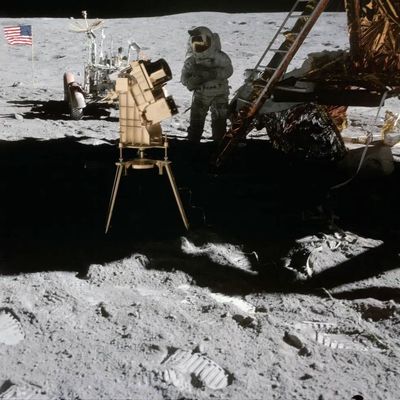
Apollo 16 astronaut John Young is pictured on the lunar surface with George Carruthers’ gold-plated Far Ultraviolet Camera/Spectrograph, the first Moon-based observatory. The Lunar Module “Orion” is on the right and the Lunar Roving Vehicle is parked in the background next to the American flag.
NASA
In April 1972, Apollo 16 astronauts placed Carruthers’ camera on the Moon’s Descartes Highlands, and humanity got its firstglimpse of Earth’s geocorona. The images it produced were as stunning for what they captured as they were for what they didn’t.
“The camera wasn’t far enough away, being at the Moon, to get the entire field of view,” said Lara Waldrop, principal investigator for the Carruthers Geocorona Observatory. “And that was really shocking — that this light, fluffy cloud of hydrogen around the Earth could extend that far from the surface.” Waldrop leads the mission from the University of Illinois Urbana-Champaign, where George Carruthers was an alumnus.
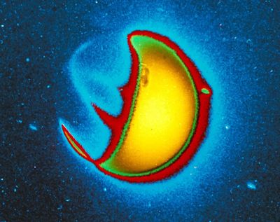
The first image of UV light from Earth’s outer atmosphere, the geocorona, taken from a telescope designed and built by George Carruthers. The telescope took the image while on the Moon during the Apollo 16 mission in 1972.
G. Carruthers (NRL) et al./Far UV Camera/NASA/Apollo 16
Our planet, in a new light
Today, the exosphere is thought to stretch at least halfway to the Moon. But the reasons for studying go beyond curiosity about its size.
As solar eruptions reach Earth, they hit the exosphere first, setting off a chain of reactions that sometimes culminate in dangerous space weather storms. Understanding the exosphere’s response is important to predicting and mitigating the effects of these storms. In addition, hydrogen — one of the atomic building blocks of water, or H2O — escapes through the exosphere. Mapping that escape process will shed light on why Earth retains water while other planets don’t, helping us find exoplanets, or planets outside our solar system, that might do the same.
NASA’s Carruthers Geocorona Observatory, named in honor of George Carruthers, is designed to capture the first continuous movies of Earth’s exosphere, revealing its full expanse and internal dynamics.
“We’ve never had a mission before that was dedicated to making exospheric observations,” said Alex Glocer, the Carruthers mission scientist at NASA’s Goddard Space Flight Center in Greenbelt, Maryland. “It’s really exciting that we’re going to get these measurements for the first time.”
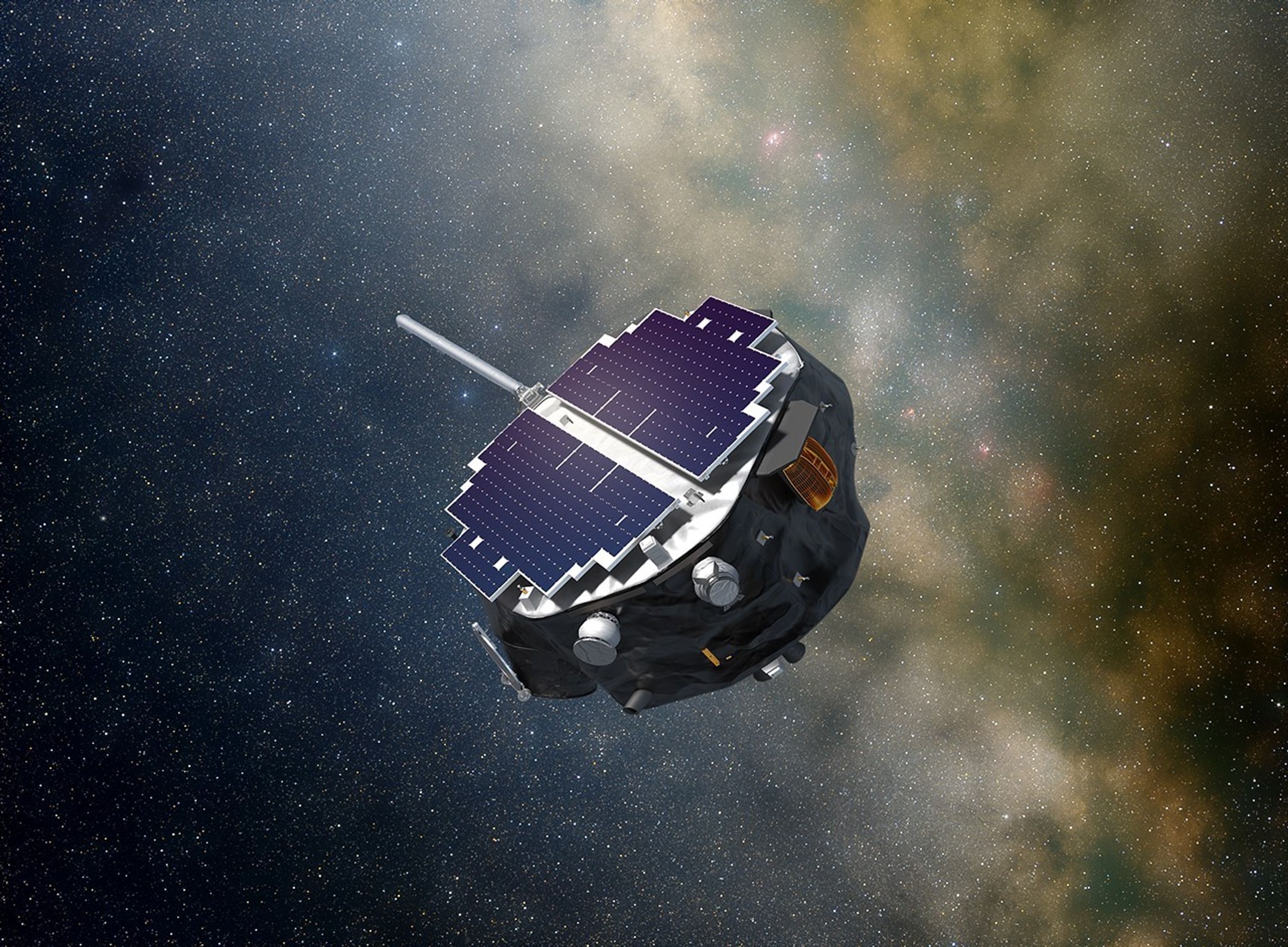
At 531 pounds and roughly the size of a loveseat sofa, the Carruthers spacecraft will launch aboard a SpaceX Falcon 9 rocket along with NASA’s IMAP (Interstellar Mapping and Acceleration Probe) spacecraft and the National Oceanic and Atmospheric Administration’s SWFO-L1 (Space Weather Follow On – Lagrange 1) space weather satellite. After launch, all three missions will commence a four-month cruise phase to Lagrange point 1 (L1), a location approximately 1 million miles closer to the Sun than Earth is. After a one-month period for science checkouts, Carruthers’ two-year science phase will begin in March 2026.
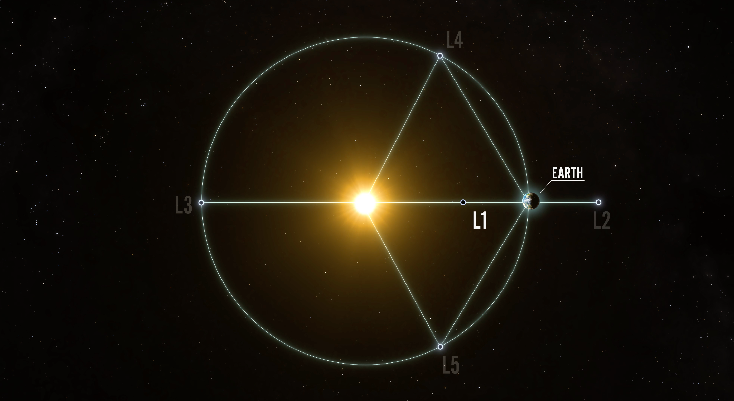
Artist’s concept of the five Sun-Earth Lagrange points in space. At Lagrange points, the gravitational pull of two large masses counteract, allowing spacecraft to reduce fuel consumption needed to remain in position. The L1 point of the Earth-Sun system affords an uninterrupted view of the Sun and will be home to three new heliophysics missions in 2025: NASA’s Interstellar Mapping and Acceleration Probe (IMAP), NASA’s Carruthers Geocorona Observatory, and NOAA’s Space Weather Follow-On – Lagrange 1 (SWFO – L1).
NASA’s Conceptual Image Lab/Krystofer Kim
From L1, roughly four times farther away than the Moon, Carruthers will capture a comprehensive view of the exosphere using two ultraviolet cameras, a near-field imager and a wide-field imager.
“The near-field imager lets you zoom up really close to see how the exosphere is varying close to the planet,” Glocer said. “The wide-field imager lets you see the full scope and expanse of the exosphere, and how it’s changing far away from the Earth’s surface.”
The two imagers will together map hydrogen atoms as they move through the exosphere and ultimately out to space. But what we learn about atmospheric escape on our home planet applies far beyond it.
“Understanding how that works at Earth will greatly inform our understanding of exoplanets and how quickly their atmospheres can escape,” Waldrop said.
By studying the physics of Earth, the one planet we know that supports life, the Carruthers Geocorona Observatory can help us know what to look for elsewhere in the universe.
The Carruthers Geocorona Observatory mission is led by Lara Waldrop from the University of Illinois Urbana-Champaign. The Space Sciences Laboratory at the University of California, Berkeley leads mission implementation, design and development of the payload in collaboration with Utah State University’s Space Dynamics Laboratory. The Carruthers spacecraft was designed and built by BAE Systems. NASA’s Explorers and Heliophysics Projects Division at the agency’s Goddard Space Flight Center in Greenbelt, Maryland, manages the mission for the agency’s Heliophysics Division at NASA Headquarters in Washington.
By Miles Hatfield NASA’s Goddard Space Flight Center, Greenbelt, Md.
NASA’s IMAP Mission to Study Boundaries of Our Home in Space
Summary
NASA’s new Interstellar Mapping and Acceleration Probe, or IMAP, will launch no earlier than Tuesday, Sept. 23 to study the heliosphere, a giant shield created by the Sun.
The mission will chart the heliosphere’s boundaries to help us better understand the protection it offers life on Earth and how it changes with the Sun’s activity.
The IMAP mission will also provide near real-time measurements of the solar wind, data that can be used to improve models predicting the impacts of space weather ranging from power-line disruptions to loss of satellites, to the health of voyaging astronauts.
Space is a dangerous place — one that NASA continues to explore for the benefit of all. It’s filled with radiation and high-energy particles that can damage DNA and circuit boards alike. Yet life endures in our solar system in part because of the heliosphere, a giant bubble created by the Sun that extends far beyond Neptune’s orbit.
With NASA’s new Interstellar Mapping and Acceleration Probe, or IMAP, launching no earlier than Tuesday, Sept. 23, humanity is set to get a better look at the heliosphere than ever before. The mission will chart the boundaries of the heliosphere to help us better understand the protection it offers and how it changes with the Sun’s activity. The IMAP mission will also provide near real-time measurements of space weather conditions essential for the Artemis campaign and deep space travel.
“With IMAP, we’ll push forward the boundaries of knowledge and understanding of our place not only in the solar system, but our place in the galaxy as a whole,” said Patrick Koehn, IMAP program scientist at NASA Headquarters in Washington. “As humanity expands and explores beyond Earth, missions like IMAP will add new pieces of the space weather puzzle that fills the space between Parker Solar Probe at the Sun and the Voyagers beyond the heliopause.”
Download this video from NASA’s Scientific Visualization Studio.
Domain of Sun
The heliosphere is created by the constant outflow of material and magnetic fields from the Sun called the solar wind. As the solar system moves through the Milky Way, the solar wind’s interaction with interstellar material carves out the bubble of the heliosphere. Studying the heliosphere helps scientists understand our home in space and how it came to be habitable.
As a modern-day celestial cartographer, IMAP will map the boundary of our heliosphere and study how the heliosphere interacts with the local galactic neighborhood beyond. It will chart the vast range of particles, dust, ultraviolet light, and magnetic fields in interplanetary space, to investigate the energization of charged particles from the Sun and their interaction with interstellar space.
The IMAP mission builds on NASA’s Voyager and IBEX (Interstellar Boundary Explorer) missions. In 2012 and 2018, the twin Voyager spacecraft became the first human-made objects to cross the heliosphere’s boundary and send back measurements from interstellar space. It gave scientists a snapshot of what the boundary looked like and where it was in two specific locations. While IBEX has been mapping the heliosphere, it has left many questions unanswered. With 30 times higher resolution and faster imaging, IMAP will help fill in the unknowns about the heliosphere.
Energetic neutral atoms: atomic messengers from our heliosphere’s edge
Of IMAP’s 10 instruments, three will investigate the boundaries of the heliosphere by collecting energetic neutral atoms, or ENAs. Many ENAs originate as positively charged particles released by the Sun but after racing across the solar system, these particles run into particles in interstellar space. In this collision, some of those positively charged particles become neutral, and an energetic neutral atom is born. The interaction also redirects the new ENAs, and some ricochet back toward the Sun.
Charged particles are forced to follow magnetic field lines, but ENAs travel in a straight line, unaffected by the twists, turns, and turbulences in the magnetic fields that permeate space and shape the boundary of the heliosphere. This means scientists can track where these atomic messengers came from and study distant regions of space from afar. The IMAP mission will use the ENAs it collects near Earth to trace back their origins and construct maps of the boundaries of the heliosphere, which would otherwise be invisible from such a distance.
“With its comprehensive state-of-the-art suite of instruments, IMAP will advance our understanding of two fundamental questions of how particles are energized and transported throughout the heliosphere and how the heliosphere itself interacts with our galaxy,” said Shri Kanekal, IMAP mission scientist at NASA’s Goddard Space Flight Center in Greenbelt, Maryland.
The IMAP mission will study the heliosphere, our home in space.
NASA/Princeton University/Patrick McPike
Space weather: monitoring solar wind
The IMAP mission will also support near real-time observations of the solar wind and energetic solar particles, which can produce hazardous conditions in the space environment near Earth. From its location at Lagrange Point 1, about 1 million miles from Earth toward the Sun, IMAP will provide around a half hour’s warning of dangerous particles headed toward our planet. The mission’s data will help with the development of models that can predict the impacts of space weather ranging from power-line disruptions to loss of satellites.
“The IMAP mission will provide very important information for deep space travel, where astronauts will be directly exposed to the dangers of the solar wind,” said David McComas, IMAP principal investigator at Princeton University.
Cosmic dust: hints of the galaxy beyond
In addition to measuring ENAs and solar wind particles, IMAP will also make direct measurements of interstellar dust — clumps of particles originating outside of the solar system that are smaller than a grain of sand. This space dust is largely composed of rocky or carbon-rich grains leftover from the aftermath of supernova explosions.
The specific elemental composition of this space dust is a postmark for where it comes from in the galaxy. Studying cosmic dust can provide insight into the compositions of stars from far outside our solar system. It will also help scientists significantly advance what we know about these basic cosmic building materials and provide information on what the material between stars is made of.
David McComas leads the mission with an international team of 27 partner institutions. APL is managing the development phase and building the spacecraft, and it will operate the mission. IMAP is the fifth mission in NASA’s Solar Terrestrial Probes Program portfolio. The Explorers and Heliophysics Projects Division at NASA Goddard manages the STP Program for the agency’s Heliophysics Division of NASA’s Science Mission Directorate. NASA’s Launch Services Program, based at NASA’s Kennedy Space Center in Florida, manages the launch service for the mission.
By Mara Johnson-Groh NASA’s Goddard Space Flight Center, Greenbelt, Md.