Normal view

There are new articles available, click to refresh the page.
Before yesterdayMain stream

NASA’s Pandora Satellite, CubeSats to Explore Exoplanets, Beyond

9 January 2026 at 09:40

6 min read

NASA’s Pandora Satellite, CubeSats to Explore Exoplanets, Beyond

Editor’s Note, Jan. 11, 2026: NASA’s Pandora and the NASA-sponsored BlackCAT and SPARCS missions lifted off at 8:44 a.m. EST (5:44 a.m. PST) Sunday, Jan. 11.

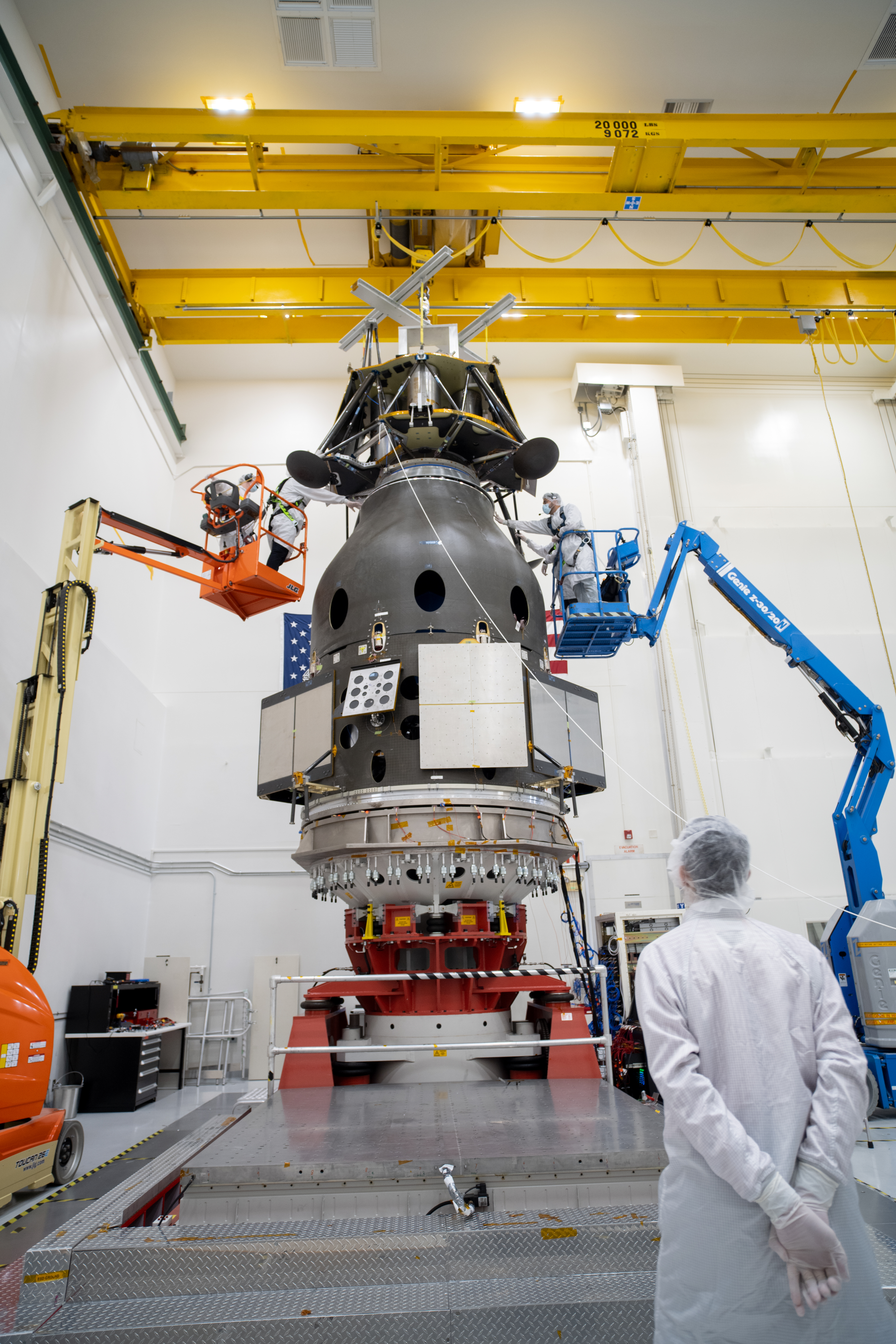
A new NASA spacecraft called Pandora is awaiting launch ahead of its journey to study the atmospheres of exoplanets, or worlds beyond our solar system, and their stars.

Along for the ride are two shoebox-sized satellites called BlackCAT (Black Hole Coded Aperture Telescope) and SPARCS (Star-Planet Activity Research CubeSat), as NASA innovates with ambitious science missions that take low-cost, creative approaches to answering questions like, “How does the universe work?” and “Are we alone?”

All three missions are set to launch Jan. 11 on a SpaceX Falcon 9 rocket from Space Launch Complex 4 East at Vandenberg Space Force Base in California. The launch window opens at 8:19 a.m. EST (5:19 a.m. PST). SpaceX will livestream the event.

The Pandora spacecraft with an exoplanet and two stars in the background
Artist’s concept of NASA’s Pandora mission, which will help scientists untangle the signals from the atmospheres of exoplanets — worlds beyond our solar system — and their stars.
NASA’s Goddard Space Flight Center/Conceptual Image Lab

“Pandora’s goal is to disentangle the atmospheric signals of planets and stars using visible and near-infrared light,” said Elisa Quintana, Pandora’s principal investigator at NASA’s Goddard Space Flight Center in Greenbelt, Maryland. “This information can help astronomers determine if detected elements and compounds are coming from the star or the planet — an important step as we search for signs of life in the cosmos.”

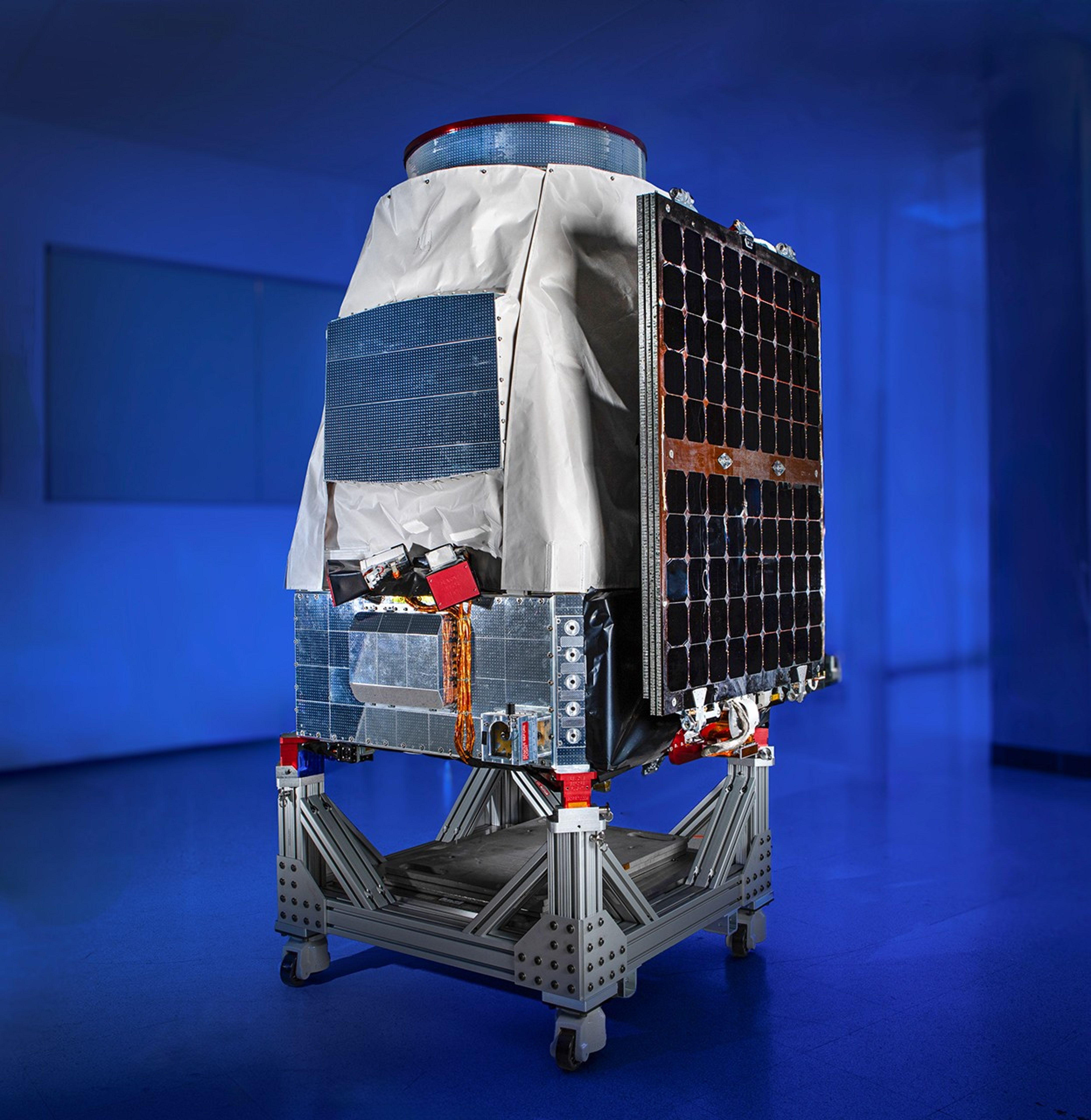
BlackCAT and SPARCS are small satellites that will study the transient, high-energy universe and the activity of low-mass stars, respectively.

Pandora will observe planets as they pass in front of their stars as seen from our perspective, events called transits.

As starlight passes through a planet’s atmosphere, it interacts with substances like water and oxygen that absorb characteristic wavelengths, adding their chemical fingerprints to the signal.

But while only a small fraction of the star’s light grazes the planet, telescopes also collect the rest of the light emitted by the star’s facing side. Stellar surfaces can sport brighter and darker regions that grow, shrink, and change position over time, suppressing or magnifying signals from planetary atmospheres. Adding a further complication, some of these areas may contain the same chemicals that astronomers hope to find in the planet’s atmosphere, such as water vapor.

All these factors make it difficult to be certain that important detected molecules come from the planet alone.

Pandora will help address this problem by providing in-depth study of at least 20 exoplanets and their host stars during its initial year. The satellite will look at each planet and its star 10 times, with each observation lasting a total of 24 hours. Many of these worlds are among the over 6,000 discovered by missions like NASA’s TESS (Transiting Exoplanet Survey Satellite).

Pandora, fully integrated, with blue-lit background
This view of the fully integrated Pandora spacecraft was taken May 19, 2025, following the mission’s successful environmental test campaign at Blue Canyon Technologies in Lafayette, Colorado. Visible are star trackers (center), multilayer insulation blankets (white), the end of the telescope (top), and the solar panel (right) in its launch configuration.
NASA/BCT

Pandora will collect visible and near-infrared light using a novel, all-aluminum 17-inch-wide (45-centimeter) telescope jointly developed by Lawrence Livermore National Laboratory in California and Corning Incorporated in Keene, New Hampshire. Pandora’s near-infrared detector is a spare developed for NASA’s James Webb Space Telescope.

Each long observation period will capture a star’s light both before and during a transit and help determine how stellar surface features impact measurements.

“These intense studies of individual systems are difficult to schedule on high-demand missions, like Webb,” said engineer Jordan Karburn, Pandora’s deputy project manager at Livermore. “You also need the simultaneous multiwavelength measurements to pick out the star’s signal from the planet’s. The long stares with both detectors are critical for tracing the exact origins of elements and compounds scientists consider indicators of potential habitability.”

Pandora is the first satellite to launch in the agency’s Astrophysics Pioneers program, which seeks to do compelling astrophysics at a lower cost while training the next generation of leaders in space science.

After launching into low Earth orbit, Pandora will undergo a month of commissioning before embarking on its one-year prime mission. All the mission’s data will be publicly available.

“The Pandora mission is a bold new chapter in exoplanet exploration,” said Daniel Apai, an astronomy and planetary science professor at the University of Arizona in Tucson where the mission’s operations center resides. “It is the first space telescope built specifically to study, in detail, starlight filtered through exoplanet atmospheres. Pandora’s data will help scientists interpret observations from past and current missions like NASA’s Kepler and Webb space telescopes. And it will guide future projects in their search for habitable worlds.”

Watch to learn more about NASA’s Pandora mission, which will revolutionize the study of exoplanet atmospheres.
NASA’s Goddard Space Flight Center

The BlackCAT and SPARCS missions will take off alongside Pandora through NASA’s Astrophysics CubeSat program, the latter supported by the Agency’s CubeSat Launch Initiative.

CubeSats are a class of nanosatellites that come in sizes that are multiples of a standard cube measuring 3.9 inches (10 centimeters) across. Both BlackCAT and SPARCS are 11.8 by 7.8 by 3.9 inches (30 by 20 by 10 centimeters). CubeSats are designed to provide cost-effective access to space to test new technologies and educate early career scientists and engineers while delivering compelling science.

The BlackCAT mission will use a wide-field telescope and a novel type of X-ray detector to study powerful cosmic explosions like gamma-ray bursts, particularly those from the early universe, and other fleeting cosmic events. It will join NASA’s network of missions that watch for these changes. Abe Falcone at Pennsylvania State University in University Park, where the satellite was designed and built, leads the mission with contributions from Los Alamos National Laboratory in New Mexico. Kongsberg NanoAvionics US provided the spacecraft bus.

The SPARCS CubeSat will monitor flares and other activity from low-mass stars using ultraviolet light to determine how they affect the space environment around orbiting planets. Evgenya Shkolnik at Arizona State University in Tempe leads the mission with participation from NASA’s Jet Propulsion Laboratory in Southern California. In addition to providing science support, JPL developed the ultraviolet detectors and the associated electronics. Blue Canyon Technologies fabricated the spacecraft bus.

Pandora is led by NASA Goddard. Livermore provides the mission’s project management and engineering. Pandora’s telescope was manufactured by Corning and developed collaboratively with Livermore, which also developed the imaging detector assemblies, the mission’s control electronics, and all supporting thermal and mechanical subsystems. The near-infrared sensor was provided by NASA Goddard. Blue Canyon Technologies provided the bus and performed spacecraft assembly, integration, and environmental testing. NASA’s Ames Research Center in California’s Silicon Valley will perform the mission’s data processing. Pandora’s mission operations center is located at the University of Arizona, and a host of additional universities support the science team.

By Jeanette Kazmierczak
NASA’s Goddard Space Flight Center, Greenbelt, Md.

Media Contact:
Claire Andreoli
301-286-1940
NASA’s Goddard Space Flight Center, Greenbelt, Md.

Facebook logo
Instagram logo

NASA’s SPHEREx Observatory Completes First Cosmic Map Like No Other

By: scarney1
18 December 2025 at 12:56

6 min read

Preparations for Next Moonwalk Simulations Underway (and Underwater)

This panoramic view of SPHEREx’s first all-sky map shows how the sky looks to the telescope. It transitions between observations of colors emitted by hot hydrogen gas (blue) and cosmic dust (red), and those primarily emitted by stars.
Credit: NASA/JPL-Caltech

Launched in March, NASA’s SPHEREx space telescope has completed its first infrared map of the entire sky in 102 colors. While not visible to the human eye, these 102 infrared wavelengths of light are prevalent in the cosmos, and observing the entire sky this way enables scientists to answer big questions, including how a dramatic event that occurred in the first billionth of a trillionth of a trillionth of a second after the big bang influenced the 3D distribution of hundreds of millions of galaxies in our universe. In addition, scientists will use the data to study how galaxies have changed over the universe’s nearly 14 billion-year history and learn about the distribution of key ingredients for life in our own galaxy.  

“It’s incredible how much information SPHEREx has collected in just six months — information that will be especially valuable when used alongside our other missions’ data to better understand our universe,” said Shawn Domagal-Goldman, director of the Astrophysics Division at NASA Headquarters in Washington. “We essentially have 102 new maps of the entire sky, each one in a different wavelength and containing unique information about the objects it sees. I think every astronomer is going to find something of value here, as NASA’s missions enable the world to answer fundamental questions about how the universe got its start, and how it changed to eventually create a home for us in it.” 

Circling Earth about 14½ times a day, SPHEREx (which stands for Spectro-Photometer for the History of the Universe, Epoch of Reionization, and Ices Explorer) travels from north to south, passing over the poles. Each day it takes about 3,600 images along one circular strip of the sky, and as the days pass and the planet moves around the Sun, SPHEREx’s field of view shifts as well. After six months, the observatory has looked out into space in every direction, capturing the entire sky in 360 degrees. 

Managed by NASA’s Jet Propulsion Laboratory in Southern California, the mission began mapping the sky in May and completed its first all-sky mosaic in December. It will complete three additional all-sky scans during its two-year primary mission, and merging those maps together will increase the sensitivity of the measurements. The entire dataset is freely available to scientists and the public.  

“SPHEREx is a mid-sized astrophysics mission delivering big science,” said JPL Director Dave Gallagher. “It’s a phenomenal example of how we turn bold ideas into reality, and in doing so, unlock enormous potential for discovery.”  

NASA’s SPHEREx has mapped the entire sky in 102 infrared colors, which are invisible to the human eye but can be used to reveal different features of the cosmos. This image features a selection of colors emitted primarily by stars (blue, green, and white), hot hydrogen gas (blue), and cosmic dust (red).
NASA/JPL-Caltech
This SPHEREx image shows a selection of the infrared colors primarily emitted by stars and galaxies. The space telescope is observing hundreds of millions of distant galaxies across the sky. Its multiwavelength view will help astronomers measure the distance to those galaxies.
NASA/JPL-Caltech
The infrared colors emitted primarily by dust (red) and hot gas (blue), key ingredients for forming new stars and planets, are seen in this SPHEREx image. Though these clouds of material cover a massive portion of the sky, they are invisible in most wavelengths of light, including those the human eye can detect.
NASA/JPL-Caltech

Superpowered telescope 

Each of the 102 colors detected by SPHEREx represents a wavelength of infrared light, and each wavelength provides unique information about the galaxies, stars, planet-forming regions, and other cosmic features therein. For example, dense clouds of dust in our galaxy where stars and planets form radiate brightly in certain wavelengths but emit no light (and are therefore totally invisible) in others. The process of separating the light from a source into its component wavelengths is called spectroscopy.  

And while a handful of previous missions has also mapped the entire sky, such as NASA’s Wide-field Infrared Survey Explorer, none have done so in nearly as many colors as SPHEREx. By contrast, NASA’s James Webb Space Telescope can do spectroscopy with significantly more wavelengths of light than SPHEREx, but with a field of view thousands of times smaller. The combination of colors and such a wide field of view is why SPHEREx is so powerful. 

“The superpower of SPHEREx is that it captures the whole sky in 102 colors about every six months. That’s an amazing amount of information to gather in a short amount of time,” said Beth Fabinsky, the SPHEREx project manager at JPL. “I think this makes us the mantis shrimp of telescopes, because we have an amazing multicolor visual detection system and we can also see a very wide swath of our surroundings.” 

To accomplish this feat, SPHEREx uses six detectors, each paired with a specially designed filter that contains a gradient of 17 colors. That means every image taken with those six detectors contains 102 colors (six times 17). It also means that every all-sky map that SPHEREx produces is really 102 maps, each in a different color.  

The observatory will use those colors to measure the distance to hundreds of millions of galaxies. Though the positions of most of those galaxies have already been mapped in two dimensions by other observatories, SPHEREx’s map will be in 3D, enabling scientists to measure subtle variations in the way galaxies are clustered and distributed across the universe.  

Each frame of this movie shows the entire sky in a different infrared wavelength, indicated by the color bar in the top right corner. Taken by NASA’s SPHEREx observatory, the maps illustrate how viewing the universe in different wavelengths of light can reveal unique cosmic features.
Credit: NASA/JPL-Caltech

Those measurements will offer insights into an event that took place in the first billionth of a trillionth of a trillionth of a second after the big bang. In this moment, called inflation, the universe expanded by a trillion-trillionfold. Nothing like it has occurred in the universe since, and scientists want to understand it better. The SPHEREx mission’s approach is one way to help in that effort. 

More about SPHEREx 

The SPHEREx mission is managed by JPL for NASA’s Astrophysics Division within the Science Mission Directorate in Washington. The telescope and the spacecraft bus were built by BAE Systems. The science analysis of the SPHEREx data is being conducted by a team of scientists at 10 institutions across the U.S., and in South Korea and Taiwan. Data is processed and archived at IPAC at Caltech in Pasadena, which manages JPL for NASA. The mission’s principal investigator is based at Caltech with a joint JPL appointment. The SPHEREx dataset is publicly available. 

For more information about the SPHEREx mission visit: 

https://science.nasa.gov/mission/spherex/

News Media Contacts

Calla Cofield 
Jet Propulsion Laboratory, Pasadena, Calif. 
626-808-2469 
calla.e.cofield@jpl.nasa.gov 

2025-144

💾

Each frame of this movie shows the entire sky in a different infrared wavelength, indicated by the widget in the top right corner. Taken by NASA’s SPHEREx ob...

NASA’s Perseverance Mars Rover Ready to Roll for Miles in Years Ahead

17 December 2025 at 13:31
NASA’s Perseverance Mars rover captured this view of a location nicknamed “Mont Musard” on Sept. 8, 2025. Made up of three images, the panorama also captures another region, “Lac de Charmes,” where the rover’s team will be looking for more rock core samples to collect in the year ahead.
NASA/JPL-Caltech/ASU/MSSS

After nearly five years on Mars, NASA’s Perseverance rover has traveled almost 25 miles (40 kilometers), and the mission team has been busy testing the rover’s durability and gathering new science findings on the way to a new region nicknamed “Lac de Charmes,” where it will be searching for rocks to sample in the coming year.

Like its predecessor Curiosity, which has been exploring a different region of Mars since 2012, Perseverance was made for the long haul. NASA’s Jet Propulsion Laboratory in Southern California, which built Perseverance and leads the mission, has continued testing the rover’s parts here on Earth to make sure the six-wheeled scientist will be strong for years to come. This past summer, JPL certified that the rotary actuators that turn the rover’s wheels can perform optimally for at least another 37 miles (60 kilometers); comparable brake testing is underway as well.

Over the past two years, engineers have extensively evaluated nearly all the vehicle’s subsystems in this way, concluding that they can operate until at least 2031.

NASA’s Perseverance used its navigation cameras to capture its record-breaking drive of 1,350.7 feet (411.7 meters) on June 19, 2025. The navcam images were combined with rover data and placed into a 3D virtual environment, resulting in this reconstruction with virtual frames inserted about every 4 inches (0.1 meters) of drive progress. Credit: NASA/JPL-Caltech

“These tests show the rover is in excellent shape,” said Perseverance’s deputy project manager, Steve Lee of JPL, who presented the results on Wednesday at the American Geophysical Union’s annual meeting, the largest gathering of planetary scientists in the United States. “All the systems are fully capable of supporting a very long-term mission to extensively explore this fascinating region of Mars.”

Perseverance has been driving through Mars’ Jezero Crater, the site of an ancient lake and river system, where it has been collecting scientifically compelling rock core samples. In fact, in September, the team announced that a sample from a rock nicknamed “Cheyava Falls” contains a potential fingerprint of past microbial life.

More efficient roving

In addition to a hefty suite of six science instruments, Perseverance packs more autonomous capabilities than past rovers. A paper published recently in IEEE Transactions on Field Robotics highlights an autonomous planning tool called Enhanced Autonomous Navigation, or ENav. The software looks up to 50 feet (15 meters) ahead for potential hazards, then chooses a path without obstacles and tells Perseverance’s wheels how to steer there.

Engineers at JPL meticulously plan each day of the rover’s activities on Mars. But once the rover starts driving, it’s on its own and sometimes has to react to unexpected obstacles in the terrain. Past rovers could do this to some degree, but not if these obstacles were clustered near each other. They also couldn’t react as far in advance, resulting in the vehicles driving slower while approaching sand pits, rocks, and ledges. In contrast, ENav’s algorithm evaluates each rover wheel independently against the elevation of terrain, trade-offs between different routes, and “keep-in” or “keep-out” areas marked by human operators for the path ahead.

“More than 90% of Perseverance’s journey has relied on autonomous driving, making it possible to quickly collect a diverse range of samples,” said JPL autonomy researcher Hiro Ono, a paper lead author. “As humans go to the Moon and even Mars in the future, long-range autonomous driving will become more critical to exploring these worlds.”

New science

A paper published Wednesday in Science details what Perseverance discovered in the “Margin Unit,” a geologic area at the margin, or inner edge, of Jezero Crater. The rover collected three samples from that region. Scientists think these samples may be particularly useful for showing how ancient rocks from Mars’ deep interior interacted with water and the atmosphere, helping create conditions supportive for life.

From September 2023 to November 2024, Perseverance ascended 1,312 feet (400 meters) of the Margin Unit, studying rocks along the way — especially those containing the mineral olivine. Scientists use minerals as timekeepers because crystals within them can record details about the precise moment and conditions in which they formed.

Jezero Crater and the surrounding area holds large reserves of olivine, which forms at high temperatures, typically deep within a planet, and offers a snapshot of what was going on in the planet’s interior. Scientists think the Margin Unit’s olivine was made in an intrusion, a process where magma pushes into underground layers and cools into igneous rock. In this case, erosion later exposed that rock to the surface, where it could interact with water from the crater’s ancient lake and carbon dioxide, which was abundant in the planet’s early atmosphere.

Those interactions form new minerals called carbonates, which can preserve signs of past life, along with clues as to how Mars’ atmosphere changed over time.

“This combination of olivine and carbonate was a major factor in the choice to land at Jezero Crater,” said the new paper’s lead author, Perseverance science team member Ken Williford of Blue Marble Space Institute of Science in Seattle. “These minerals are powerful recorders of planetary evolution and the potential for life.”

Together, the olivine and carbonates record the interplay between rock, water, and atmosphere inside the crater, including how each changed over time. The Margin Unit’s olivine appeared to have been altered by water at the base of the unit, where it would have been submerged. But the higher Perseverance went, the more the olivine bore textures associated with magma chambers, like crystallization, and fewer signs of water alteration.

As Perseverance leaves the Margin Unit behind for Lac de Charmes, the team will have the chance to collect new olivine-rich samples and compare the differences between the two areas.

More about Perseverance

Managed for NASA by Caltech, NASA’s Jet Propulsion Laboratory in Southern California built and manages operations of the Perseverance rover on behalf of the agency’s Science Mission Directorate as part of NASA’s Mars Exploration Program portfolio.

To learn more about Perseverance, visit:

https://science.nasa.gov/mission/mars-2020-perseverance

News Media Contacts

Andrew Good / DC Agle
Jet Propulsion Laboratory, Pasadena, Calif.
818-393-2433 / 818-393-9011
andrew.c.good@jpl.nasa.gov / agle@jpl.nasa.gov

Karen Fox / Molly Wasser
NASA Headquarters, Washington
240-285-5155 / 240-419-1732
karen.c.fox@nasa.gov / molly.l.wasser@nasa.gov

2025-143

💾

This video shows the Perseverance Mars Rover’s point of view during a record-breaking drive that occurred June 19, 2025, the 1,540th Martian day, or sol, of ...

NASA Study Suggests Saturn’s Moon Titan May Not Have Global Ocean

By: scarney1
17 December 2025 at 11:01

6 min read

Preparations for Next Moonwalk Simulations Underway (and Underwater)

Artist's rendering of NASA's Cassini spacecraft observing a sunset through Titan's hazy atmosphere. Against the blackness of space, the moon is backlit, with a ring of white and a ring of blue light marking its outer edge, with the Sun as a point of bright light peeking from the upper-right edge of the disc. Cassini is dimly lit in the foreground partially blocking the moon, a dull gold with a large white antenna dish, and three spindly protrusions coming out of its center at 90-degree angles to each other.
This artist’s concept depicts NASA’s Cassini spacecraft performing one of its many close flybys of Titan, Saturn’s largest moon. By analyzing the Doppler shift of radio signals traveling to and from Earth, the mission precisely measured Titan’s gravity field.
NASA/JPL-Caltech

A key discovery from NASA’s Cassini mission in 2008 was that Saturn’s largest moon Titan may have a vast water ocean below its hydrocarbon-rich surface. But reanalysis of mission data suggests a more complicated picture: Titan’s interior is more likely composed of ice, with layers of slush and small pockets of warm water that form near its rocky core.  

Led by researchers at NASA’s Jet Propulsion Laboratory in Southern California and published in the journal Nature on Wednesday, the new study could have implications for scientists’ understanding of Titan and other icy moons throughout our solar system. 

“This research underscores the power of archival planetary science data. It is important to remember that the data these amazing spacecraft collect lives on so discoveries can be made years, or even decades, later as analysis techniques get more sophisticated,” said Julie Castillo-Rogez, senior research scientist at JPL and a coauthor of the study. “It’s the gift that keeps giving.” 

To remotely probe planets, moons, and asteroids, scientists study the radio frequency communications traveling back and forth between spacecraft and NASA’s Deep Space Network. It’s a multilayered process. Because a moon’s body may not have a uniform distribution of mass, its gravity field will change as a spacecraft flies through it, causing the spacecraft to speed up or slow down slightly. In turn, these variations in speed alter the frequency of the radio waves going to and from the spacecraft — an effect known as Doppler shift. Analyzing the Doppler shift can lend insight into a moon’s gravity field and its shape, which can change over time as it orbits within its parent planet’s gravitational pull. 

This shape shifting is called tidal flexing. In Titan’s case, Saturn’s immense gravitational field squeezes the moon when Titan is closer to the planet during its slightly elliptical orbit, and it stretches the moon when it is farthest. Such flexing creates energy that is lost, or dissipated, in the form of internal heating. 

When mission scientists analyzed radio-frequency data gathered during the now-retired Cassini mission’s 10 close approaches of Titan, they found the moon to be flexing so much that they concluded it must have a liquid interior, since a solid interior would have flexed far less. (Think of a balloon filled with water versus a billiard ball.)  

New technique 

The new research highlights another possible explanation for this malleability: an interior composed of layers featuring a mix of ice and water that allows the moon to flex. In this scenario, there would be a lag of several hours between Saturn’s tidal pull and when the moon shows signs of flexing — much slower than if the interior were fully liquid. A slushy interior would also exhibit a stronger energy dissipation signature in the moon’s gravity field than a liquid one, because these slush layers would generate friction and produce heat when the ice crystals rub against one another. But there was nothing apparent in the data to suggest this was happening. 

So the study authors, led by JPL postdoctoral researcher Flavio Petricca, looked more closely at the Doppler data to see why. By applying a novel processing technique, they reduced the noise in the data. What emerged was a signature that revealed strong energy loss deep inside Titan. The researchers interpreted this signature to be coming from layers of slush, overlaid by a thick shell of solid ice. 

Based on this new model of Titan’s interior, the researchers suggest that the only liquid would be in the form of pockets of meltwater. Heated by dissipating tidal energy, the water pockets slowly travel toward the frozen layers of ice at the surface. As they rise, they have the potential to create unique environments enriched by organic molecules being supplied from below and from material delivered via meteorite impacts on the surface.  

“Nobody was expecting very strong energy dissipation inside Titan. But by reducing the noise in the Doppler data, we could see these smaller wiggles emerge. That was the smoking gun that indicates Titan’s interior is different from what was inferred from previous analyses,” said Petricca. “The low viscosity of the slush still allows the moon to bulge and compress in response to Saturn’s tides, and to remove the heat that would otherwise melt the ice and form an ocean.” 

Potential for life 

“While Titan may not possess a global ocean, that doesn’t preclude its potential for harboring basic life forms, assuming life could form on Titan. In fact, I think it makes Titan more interesting,” Petricca added. “Our analysis shows there should be pockets of liquid water, possibly as warm as 20 degrees Celsius (68 degrees Fahrenheit), cycling nutrients from the moon’s rocky core through slushy layers of high-pressure ice to a solid icy shell at the surface.” 

More definitive information could come from NASA’s next mission to Saturn. Launching no earlier than 2028, the agency’s Dragonfly mission to the hazy moon could provide the ground truth. The first-of-its-kind rotorcraft will explore Titan’s surface to investigate the moon’s habitability. Carrying a seismometer, the mission may provide key measurements to probe Titan’s interior, depending on what seismic events occur while it is on the surface. 

More about Cassini 

The Cassini-Huygens mission was a cooperative project of NASA, ESA (European Space Agency), and the Italian Space Agency. A division of Caltech in Pasadena, JPL managed the mission for NASA’s Space Mission Directorate in Washington and designed, developed, and assembled the Cassini orbiter. 

To learn more about NASA’s Cassini mission, visit:

https://science.nasa.gov/mission/cassini/

News Media Contacts 

Ian J. O’Neill 
Jet Propulsion Laboratory, Pasadena, Calif. 
818-354-2649 
ian.j.oneill@jpl.nasa.gov 

Karen Fox / Alana Johnson 
NASA Headquarters, Washington
202-358-1600 / 202-358-1501 
karen.c.fox@nasa.gov / alana.r.johnson@nasa.gov 

2025-142

NASA JPL Shakes Things Up Testing Future Commercial Lunar Spacecraft

By: scarney1
16 December 2025 at 14:43

6 min read

Preparations for Next Moonwalk Simulations Underway (and Underwater)

A time-lapse video recorded at JPL in October shows engineers and technicians moving and attaching a full-scale model of Firefly Aerospace’s Blue Ghost lunar lander on top of two lunar orbiters. The full stack was then subjected to a vibration test that mimics the violent action of rocket launch.
NASA/JPL-Caltech

The same historic facilities that some 50 years ago prepared NASA’s twin Voyager probes for their ongoing interstellar odyssey are helping to ready a towering commercial spacecraft for a journey to the Moon. Launches involve brutal shaking and astonishingly loud noises, and testing in these facilities mimics those conditions to help ensure mission hardware can survive the ordeal. The latest spacecraft to get this treatment are Firefly Aerospace’s Blue Ghost Mission 2 vehicles, set to launch to the Moon’s far side next year. 

The Environmental Test Laboratory at NASA’s Jet Propulsion Laboratory in Southern California is where dozens of robotic spacecraft have been subjected to powerful jolts, extended rattling, high-decibel blasts of sound, and frigid and scorching temperatures, among other trials. Constructed in the 1960s and modernized over the years, the facilities have prepared every NASA spacecraft built or assembled at JPL for the rigors of space, from the Ranger spacecraft of the dawning Space Age to the Perseverance Mars rover to Europa Clipper, currently en route to the Jupiter system.  

That legacy, and the decades of accumulated experience of the Environmental Test Laboratory team at JPL, is also supporting industry efforts to return to the Moon as part of NASA’s CLPS (Commercial Lunar Payload Services) initiative and its Artemis campaign, which will bring astronauts back to the lunar surface.  

In recent months, a full-scale model of Firefly’s uncrewed Blue Ghost Mission 2 spacecraft was put through its paces by the experts in the lab’s vibration and acoustic testing facilities. Lessons learned with this model, called a structural qualification unit, will be applied to upcoming testing of the spacecraft that will fly to the Moon as early as 2026 through NASA’s CLPS. 

“There’s a lot of knowledge gained over the years, passed from one generation of JPL engineers to another, that we bring to bear to support our own missions as well as commercial efforts,” said Michel William, a JPL engineer in the Environmental Test Laboratory who led the testing. “The little details that go into getting these tests right — nobody teaches you that in school, and it’s such a critical piece of space launch.”  

Engineers and technicians secure a full-scale model of Firefly’s Blue Ghost lunar lander atop the other spacecraft that make up the company’s second delivery to the lunar surface. Environmental testing for the spacecraft took place in a clean room at NASA’s Jet Propulsion Laboratory in October.
NASA/JPL-Caltech

Testing just right 

The Environmental Test Laboratory team led environmental testing for Firefly’s Blue Ghost Mission 1 lander in 2024, and seeing the spacecraft achieve a soft Moon landing in March was a point of pride for them. Firefly’s next CLPS delivery debuts a dual-spacecraft configuration and hosts multiple international payloads, with the company’s Elytra Dark orbital vehicle stacked below the Blue Ghost lunar lander. Standing 22 feet (6.9 meters) high, the full structure is more than three times as tall as the Mission 1 lander. 

This fall, a structural qualification model of the full stack was clamped to a “shaker table” inside a clean room at JPL and repeatedly rattled in three directions while hundreds of sensors monitored the rapid movement. Then, inside a separate acoustic testing chamber, giant horns blared at it from openings built into the room’s 16-inch-thick (41-centimeter-thick) concrete walls. The horns use compressed nitrogen gas to pummel spacecraft with up to 153 decibels, noise loud enough to cause permanent hearing loss in a human.  

Each type of test involves several increasingly intense iterations. Between rounds, JPL’s dynamics environment experts analyze the data to compare what the spacecraft experienced to computer model predictions. Sometimes a discrepancy leads to hardware modifications, sometimes a tweak to the computer model. Engineers and technicians are careful to push the hardware, but not too far. 

“You can either under-test or over-test, and both are bad,” William said. “If you over-test, you can break your hardware. If you under-test, it can break on the rocket. It’s a fine line.” 

Since the model isn’t itself launching to the Moon, Firefly’s recent Environmental Test Laboratory visit didn’t include several types of trials that are generally completed only for flight hardware. A launchpad-bound spacecraft would undergo electromagnetic testing to ensure that signals from its electronic parts don’t interfere with one another. And, in what is probably the most well-known environmental test, flight-bound hardware is baked or chilled at extreme temperatures in a thermal vacuum chamber from which all the air is sucked out. The multiple thermal vacuum chamber facilities at JPL include two large historic “space simulators” built within NASA’s first few years of existence: a chamber that’s 10 feet in diameter and another that’s 25 feet across

A full-scale model of Firefly Aerospace’s Blue Ghost Mission 2 lunar lander is prepared for delivery into a clean room at JPL’s Environmental Test Laboratory in September.
NASA/JPL-Caltech
Technicians and engineers at JPL ready a fixture that will attach a full-scale model of Firefly Aerospace’s Blue Ghost Mission 2 lunar lander, visible in the background, to a “shaker table” that tests a spacecraft’s readiness to survive the stresses of launch.
NASA/JPL-Caltech

Qualifying for launch 

The completion of Environmental Test Laboratory testing on Firefly’s structural qualification model helps prove the spacecraft will survive its ride out of Earth’s atmosphere aboard a SpaceX Falcon 9 rocket. Firefly’s Blue Ghost Mission 2 team is now turning its focus to completing assembly and testing of the flight hardware for launch. 

Once at the Moon, the Blue Ghost lander will touch down on the far side, delivering its payloads to the surface. Those include LuSEE-Night, a radio telescope that is a joint effort by NASA, the U.S. Department of Energy, and University of California, Berkeley’s Space Sciences Laboratory. A payload developed at JPL called User Terminal will test a compact, low-cost S-band radio communications system that could enable future far-side missions to talk to each other and to relay orbiters.  

Meantime, Firefly’s Elytra Dark orbital vehicle will have deployed into lunar orbit ESA’s (European Space Agency’s) Lunar Pathfinder communications satellite — a payload on which NASA is collaborating. Both vehicles will remain in orbit and able to relay data from the far-side surface back to Earth.  

“Firefly’s Blue Ghost Mission 2 will deliver both NASA and international commercial payloads to further prove out technologies for Artemis and help enable a long-term presence on the Moon,” said Ray Allensworth, Firefly’s spacecraft program director. “The extensive spacecraft environmental testing we did at JPL for Mission 1 was a critical step in Firefly’s test campaign for our historic lunar mission. Now we’re collaborating again to support a successful repeat on the Moon that will unlock even more insights for future robotic and human missions.” 

News Media Contact 

Melissa Pamer 
Jet Propulsion Laboratory, Pasadena, Calif. 
626-314-4928 
melissa.pamer@jpl.nasa.gov 

2025-141

One of NASA’s Key Cameras Orbiting Mars Takes 100,000th Image

By: scarney1
16 December 2025 at 11:00

3 min read

Preparations for Next Moonwalk Simulations Underway (and Underwater)

An overhead color view of the Martian surface shows rough and varied terrain in shades ranging from golden tan to electric blue. At upper left, the ground appears more flat and cratered than other areas of the image, and is colored dark grayish-blue with highlights of silver and tan. The upper right corner of the image looks like wavy sand dunes, in shades of dark blue with bright silvery highlights, except for one apparent ridgeline that stands out as an elongated S-shape in electric blue. The bottom half of the image shows more mountainous terrain that gets lighter and more gold-colored nearer the bottom of the frame. A pair of smooth valleys run diagonally between the peaks, from around the center of the image toward the bottom-left corner; the upper one is a shade of silvery blue and the bottom one is a grayish-gold, and both have ridges lining their upper walls, looking like lines of sharp teeth biting into the valleys.
This view of a region called Syrtis Major is from the 100,000th image captured by NASA’s Mars Reconnaissance Orbiter using its HiRISE camera. Over nearly 20 years, HiRISE has helped scientists understand how the Red Planet’s surface is constantly changing.
NASA/JPL-Caltech/University of Arizona

Mesas and dunes stand out in the view snapped by HiRISE, one of the imagers aboard the agency’s Mars Reconnaissance Orbiter.

After nearly 20 years at the Red Planet, NASA’s Mars Reconnaissance Orbiter (MRO) has snapped its 100,000th image of the surface with its HiRISE camera. Short for High Resolution Imaging Science Experiment, HiRISE is the instrument the mission relies on for high-resolution images of features ranging from impact craters, sand dunes, and ice deposits to potential landing sites. Those images, in turn, help improve our understanding of Mars and prepare for NASA’s future human missions there. 

Captured Oct. 7, this milestone image from the spacecraft shows mesas and dunes within Syrtis Major, a region about 50 miles (80 kilometers) southeast of Jezero Crater, which NASA’s Perseverance rover is exploring. Scientists are analyzing the image to better understand the source of windblown sand that gets trapped in the region’s landscape, eventually forming dunes. 

“HiRISE hasn’t just discovered how different the Martian surface is from Earth, it’s also shown us how that surface changes over time,” said MRO’s project scientist, Leslie Tamppari of NASA’s Jet Propulsion Laboratory in Southern California. “We’ve seen dune fields marching along with the wind and avalanches careening down steep slopes.” 

Watch highlights of images captured by HiRISE, the high-resolution camera aboard NASA’s Mars Reconnaissance Orbiter, including its 100,000th image, showing the plains and dunes of Syrtis Major.
NASA/JPL-Caltech/University of Arizona

The subject of the 100,000th image was recommended by a high school student through the HiWish site, where anyone can suggest parts of the planet to study. Team members at University of Arizona in Tucson, which operates the camera, also make 3D models of HiRISE imagery so that viewers can experience virtual flyover videos

“Rapid data releases, as well as imaging targets suggested by the broader science community and public, have been a hallmark of HiRISE,” said the camera’s principal investigator, Shane Byrne of the University of Arizona in Tucson. “One hundred thousand images just like this one have made Mars more familiar and accessible for everyone.” 

More about MRO 

NASA’s Jet Propulsion Laboratory in Southern California manages MRO for NASA’s Science Mission Directorate in Washington as part of NASA’s Mars Exploration Program portfolio. Lockheed Martin Space in Denver built MRO and supports its operations. 

The University of Arizona in Tucson operates HiRISE, which was built by Ball Aerospace & Technologies Corp., in Boulder, Colorado. 

For more information, visit:

https://science.nasa.gov/mission/mars-reconnaissance-orbiter

News Media Contacts

Andrew Good 
Jet Propulsion Laboratory, Pasadena, Calif. 
818-393-2433 
andrew.c.good@jpl.nasa.gov 

Karen Fox / Molly Wasser 
NASA Headquarters, Washington
202-358-1600
karen.c.fox@nasa.gov / molly.l.wasser@nasa.gov

2025-140

Share

Details

Last Updated
Dec 16, 2025
❌
❌