This letter from SARA is to issue a waiver for NASA grantees attending LPSC2026, allowing them to be reimbursed out of their grants for their actual lodging, although it’s expected to be above the approved GSA amount. This waiver does not supersede the travel policy of your institution if it is more restrictive. Note: I have specified grants (including cooperative agreements). This may also apply to those traveling on NASA contracts, but they should communicate with their contracting officers.
The host hotel for the 57th Lunar and Planetary Science Conference on March 16–20, 2026, is The Woodlands Waterway Marriott Hotel and Convention Center. Hotel information for this conference may be found at https://www.hou.usra.edu/meetings/lpsc2026/plan/
The GSA-allowed daily lodging expense for March 2026 for zip code 77380 (for The Woodlands Waterway Marriott Hotel and Convention Center) is $128 per night. Many of the hotels may be significantly higher than the GSA allowed rate of $128. Grantee travelers may need a waiver to cover lodging in excess of the GSA value, depending on the travel policy of your organization. This waiver does not supersede the travel policy of your institution if it is more restrictive.
By the power vested in me by the NSSC to issue approval of the actual lodging costs for a conference in “bulk” instead of individual approvals, I hereby affirm that for the 57th Lunar and Planetary Science Conference NASA, SMD grants may be charged up to $276/night plus taxes and fees, consistent with the average actual cost of the conference hotel, even though this exceeds the $128 allotted for lodging by GSA for The Woodlands for March 2026.
NASA announced Tuesday the selection of three new science investigations that will strengthen humanity’s understanding and exploration of the Moon. As part of the agency’s CLPS (Commercial Lunar Payload Services) initiative and Artemis campaign, American companies will deliver these research payloads to the lunar surface no earlier than 2028.
“With CLPS, NASA has been taking a new approach to lunar science, relying on U.S. industry innovation to travel to the surface of the Moon and enable scientific discovery,” said Joel Kearns, deputy associate administrator for exploration, Science Mission Directorate, NASA Headquarters in Washington. “These selections continue this pipeline of lunar exploration, through research that will not only expand our knowledge about the Moon’s history and environment, but also inform future human safety and navigation on the Moon and beyond.”
The selected scientific payloads are:
Emission Imager for Lunar Infrared Analysis in 3D (EMILIA-3D). The EMILIA-3D payload will create three-dimensional thermal models of the lunar terrain, using a thermal imager to measure the temperature of the landscape coupled with a stereo pair of visible-light cameras. These models will help the U.S. better image and navigate the Moon’s surface through improved understanding of the properties of the dusty lunar soil, called regolith, and what temperature measurements convey about the lunar surface. The principal investigator is Andrew Ryan at the University of Arizona.
Lunar Instrumentation for Subsurface Thermal Exploration with Rapidity (LISTER). The LISTER instrument will measure the heat flow of the Moon’s interior by drilling beneath the lunar surface, pausing at intervals to measure temperature changes and the ability of the subsurface material to conduct heat. A previous version of LISTER flew on the Blue Ghost Mission 1 CLPS delivery to the Moon’s near side, where it took eight temperature and thermal conductivity measurements and drilled down to about three feet beneath the lunar surface. This new LISTER investigation will study the heat flow generated by the Moon itself, giving us a better understanding of its thermal history. The principal investigator is Seiichi Nagihara at Texas Tech University.
Site-agnostic Energetic Lunar Ion and Neutron Environment (SELINE). The SELINE payload will provide new insight into the Moon’s radiation environment by studying, for the first time at the lunar surface, the radiation from both primary galactic cosmic rays and their secondary particles and how this radiation interacts with the lunar regolith. Data from SELINE will improve our understanding of the planetary processes at work on the Moon, as well as inform space weather preparation and safety for long-term human exploration of the lunar surface. The principal investigator is Drew Turner at Johns Hopkins University.
These science experiments, selected through NASA’s Payloads and Research Investigations on the Surface of the Moon call for proposals, do not require a specific landing site on the lunar surface to gather their data, and NASA will assign them to specific CLPS delivery task orders at a later time.
NASA uses CLPS to send scientific instruments and technology demonstrations to advance capabilities for science, exploration, or commercial development of the Moon and beyond. By supporting a steady cadence of lunar deliveries, the agency will continue to enable a growing lunar economy while leveraging the entrepreneurial innovation of the commercial space industry.
La temperatura global de la superficie terrestre en 2025 fue un poco más cálida que en 2023 pero, dentro de los márgenes de error, ambos años está prácticamente empatados, según un análisis realizado por científicos de la NASA. Desde que comenzaron los registros en 1880, 2024 sigue siendo el año más caluroso.
Las temperaturas globales en 2025 fueron más frías que en 2024, con temperaturas promedio de 1,19° Celsius (2,14° Fahrenheit) por encima del promedio para el período de 1951 a 1980.
El análisis del Instituto Goddard de Estudios Espaciales de la NASA incluye datos de la temperatura del aire obtenidos por más de 25.000 estaciones meteorológicas en todo el mundo, así como por instrumentos a bordo de barcos y boyas que miden la temperatura de la superficie del mar, y estaciones de investigación en la Antártida. Los datos son analizados utilizando métodos que toman en cuenta la distribución cambiante de las estaciones de medición de temperatura y los efectos del calentamiento urbano que podrían sesgar los cálculos.
Además, análisis independientes realizados por la Administración Nacional Oceánica y Atmosférica (NOAA, por sus siglas en inglés), la plataforma Berkeley Earth, el Centro Hadley (que forma parte del servicio meteorológico nacional del Reino Unido) y los Servicios Climáticos Copernicus de Europa han concluido que la temperatura global de la superficie para 2025 ha sido la tercera más calurosa que se haya registrado. Estos científicos utilizan gran parte de los mismos datos de temperatura en sus análisis, pero emplean diferentes metodologías y modelos; todos ellos muestran la misma tendencia al calentamiento continuo.
El conjunto completo de datos de la NASA sobre las temperaturas de la superficie global, así como los detalles de cómo los científicos de la NASA llevaron a cabo el análisis, están disponibles públicamente en línea (en inglés).
Para obtener más información sobre los programas de ciencias de la Tierra de la NASA, visita el sitio web:
Earth’s global surface temperature in 2025 was slightly warmer than 2023 – but within the margin of error the two years are effectively tied according to an analysis by NASA scientists. Since record-keeping began in 1880, the hottest year on record remains 2024.
Global temperatures in 2025 were cooler than 2024, with average temperatures of 2.14 degrees Fahrenheit (1.19 degrees Celsius) above the 1951 to 1980 average.
The analysis from NASA’s Goddard Institute for Space Studies includes air temperature data acquired by more than 25,000 meteorological stations around the world, from ship- and buoy-based instruments measuring sea surface temperature, and Antarctic research stations. The data are analyzed using methods that account for the changing distribution of temperature stations and for urban heating effects that could skew the calculations.
Additionally, independent analyses by the National Oceanic and Atmospheric Administration, Berkeley Earth, the Hadley Centre (part of the United Kingdom’s weather forecasting Met Office), and Copernicus Climate Services in Europe have concluded the global surface temperature for 2025 was the third warmest on record. These scientists use much of the same temperature data in their analyses but employ different methodologies and models, which exhibit the same ongoing warming trend.
NASA’s full dataset of global surface temperatures, as well as details of how agency scientists conducted the analysis are available online.
For more information about NASA’s Earth science programs, visit:
In sending a car-sized rotorcraft to explore Saturn’s moon Titan, NASA’s Dragonfly mission will undertake an unprecedented voyage of scientific discovery. And the work to ensure that this first-of-its-kind project can fulfill its ambitious exploration vision is underway in some of the nation’s most advanced space simulation and testing laboratories.
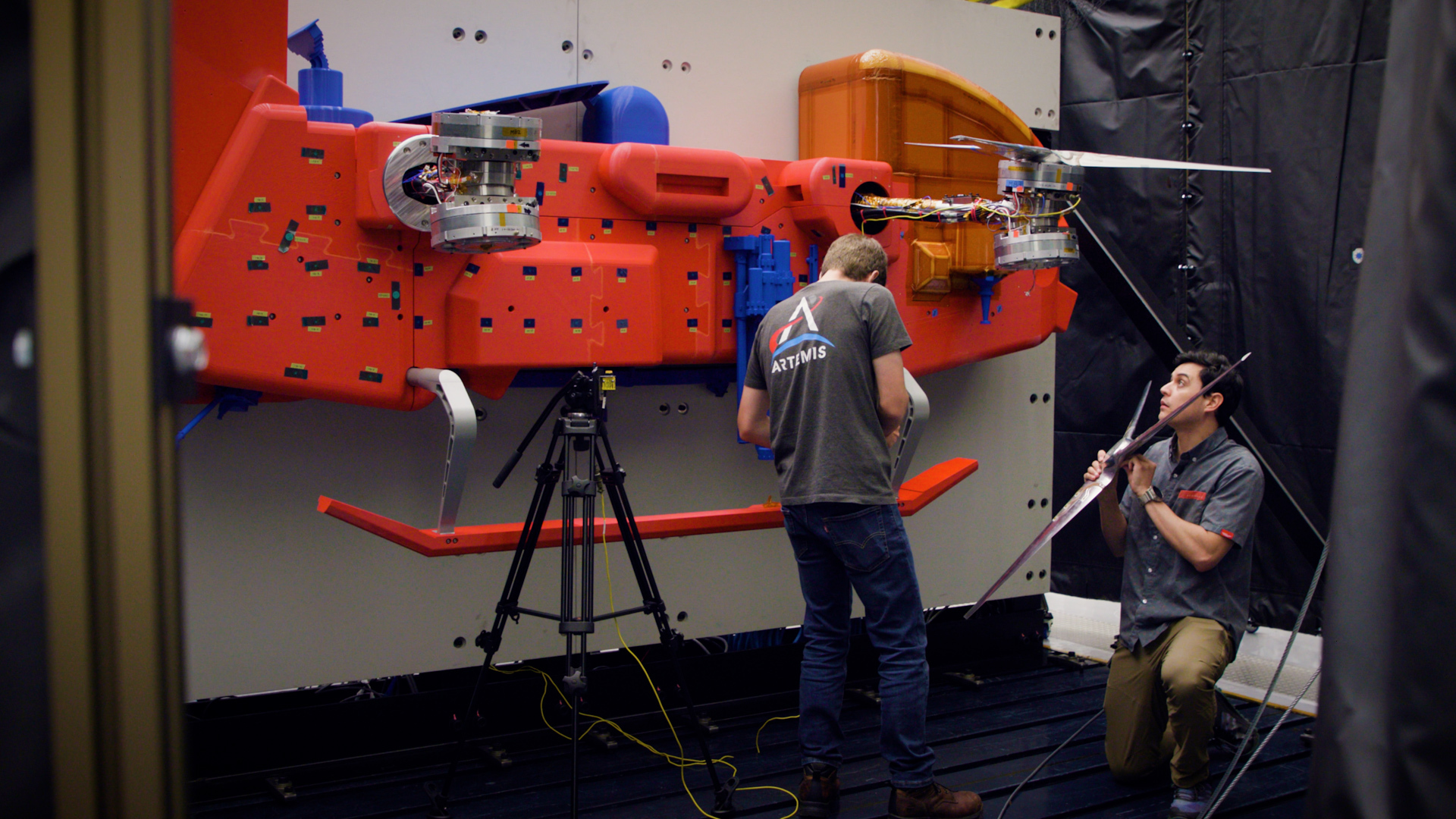
From left, Johns Hopkins APL engineers Tyler Radomsky and Felipe Ruiz install a rotor on the Dragonfly test model at the Transonic Dynamics Tunnel at NASA’s Langley Research Center in Virginia.
NASA
Set for launch in in 2028, the Dragonfly rotorcraft is being designed and built at the Johns Hopkins Applied Physics Laboratory (APL) in Laurel, Maryland, with contributions from organizations around the world. On arrival in 2034, Dragonfly will exploit Titan’s dense atmosphere and low gravity to fly to dozens of locations, exploring varied environments from organic equatorial dunes to an impact crater where liquid water and complex organic materials essential to life (at least as we know it) may have existed together.
Aerodynamic testing
When full rotorcraft integration and testing begins in February, the team will tap into a trove of data gathered through critical technical trials conducted over the past three years, including, most recently, two campaigns at the Transonic Dynamics Tunnel (TDT) facility at NASA’s Langley Research Center in Hampton, Virginia.
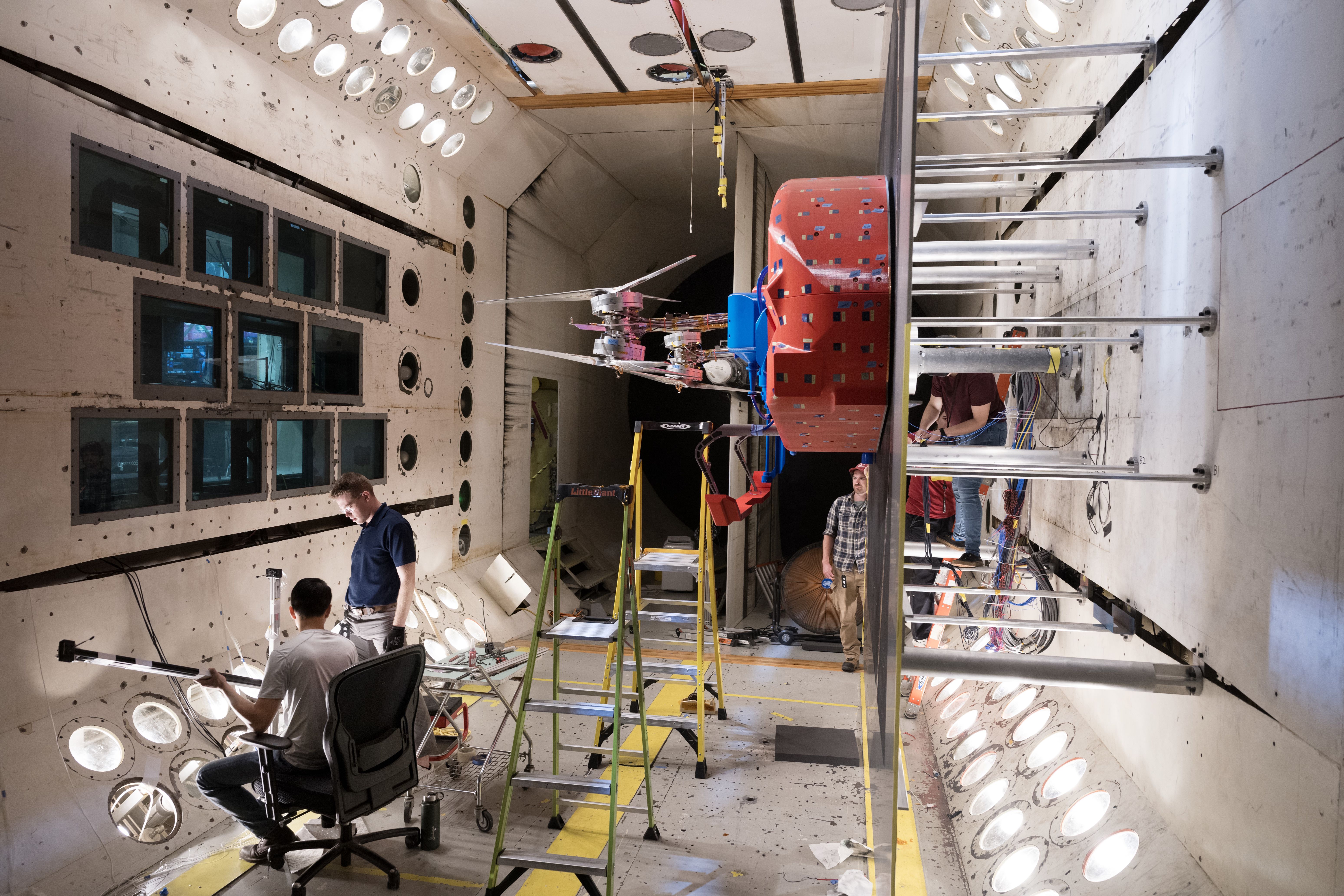
From left, Charles Pheng, Ryan Miller, John Kayrouz, Kristen Carey and Josie Ward prepare for the first aeromechanical performance tests of the full-scale Dragonfly rotors in the Transonic Dynamics Tunnel at NASA’s Langley Research Center in Virginia.
NASA
The TDT is a versatile 16-foot-high, 16-foot-wide, 20-foot-long testing hub that has hosted studies for NASA, the Department of War, the aircraft industry and an array of universities.
Over five weeks, from August into September, the team evaluated the performance of Dragonfly’s rotor system – which provides the lift for the lander to fly and enables it to maneuver – in Titan-like conditions, looking at aeromechanical performance factors such as stress on the rotor arms, and effects of vibration on the rotor blades and lander body. In late December, the team also wrapped up a set of aerodynamics tests on smaller-scale Dragonfly rotor models in the TDT.
“When Dragonfly enters the atmosphere at Titan and parachutes deploy after the heat shield does its job, the rotors are going to have to work perfectly the first time,” said Dave Piatak, branch chief for aeroelasticity at NASA Langley. “There’s no room for error, so any concerns with vehicle structural dynamics or aerodynamics need to be known now and tested on the ground. With the Transonic Dynamics Tunnel here at Langley, NASA offers just the right capability for the Dragonfly team to gather this critical data.”
Critical parts
In his three years as an experimental machinist at APL, Cory Pennington has crafted parts for projects dispatched around the globe. But fashioning rotors for a drone to explore another world in our solar system? That was new – and a little daunting.
“The rotors are some of the most important parts on Dragonfly,” Pennington said. “Without the rotors, it doesn’t fly – and it doesn’t meet its mission objectives at Titan.”
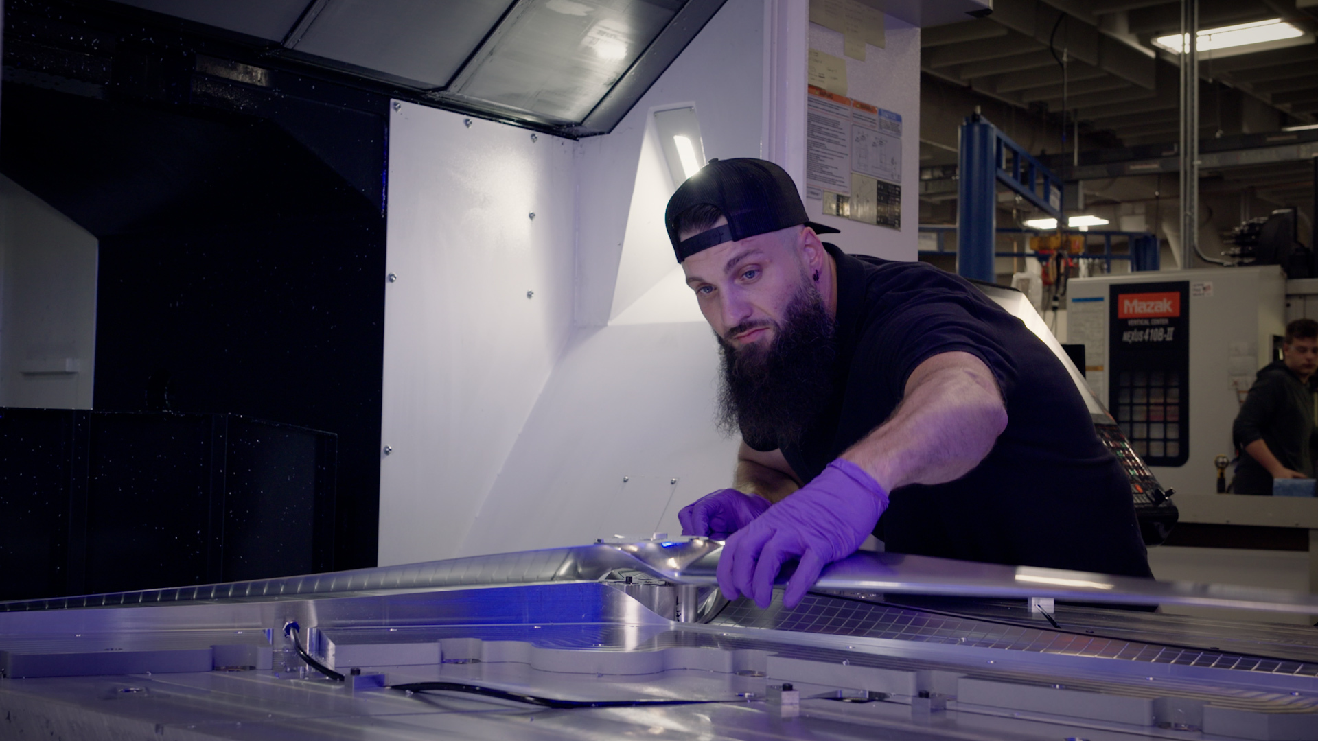
Experimental machinist Cory Pennington examines a freshly milled, full-scale Dragonfly rotor in the machine shop at the Johns Hopkins Applied Physics Laboratory (APL) in Laurel, Maryland.
NASA/Johns Hopkins APL
Pennington and team cut Dragonfly’s first rotors on Nov. 1, 2024. They refined the process as they went: starting with waterjet paring of 1,000-pound aluminum blocks, followed by rough machining, cover fitting, vent-hole drilling and hole-threading. After an inspection, the parts were cleaned, sent out for welding and returned for final finishing.
“We didn’t have time or materials to make test parts or extras, so every cut had to be right the first time,” Pennington said, adding that the team also had to find special tools and equipment to accommodate some material changes and design tweaks.
The team was able to deliver the parts a month early. Engineers set up and spin-tested the rotors at APL – attached to a full-scale model representing half of the Dragonfly lander – before transporting the entire package to the TDT at NASA Langley in late July.
“On Titan, we’ll control the speeds of Dragonfly’s different rotors to induce forward flight, climbs, descents and turns,” said Felipe Ruiz, lead Dragonfly rotor engineer at APL.
“It’s a complicated geometry going to a flight environment that we are still learning about. So the wind tunnel tests are one of the most important venues for us to demonstrate the design.”
And the rotors passed the tests.
“Not only did the tests validate the design team’s approach, we’ll use all that data to create high-fidelity representations of loads, forces and dynamics that help us predict Dragonfly’s performance on Titan with a high degree of confidence,” said Rick Heisler, wind tunnel test lead from APL.
Next, the rotors will undergo fatigue and cryogenic trials under simulated Titan conditions, where the temperature is minus 290 degrees Fahrenheit (minus 178 degrees Celsius), before building the actual flight rotors.
“We’re not just cutting metal — we’re fabricating something that’s going to another world,” Pennington said. “It’s incredible to know that what we build will fly on Titan.”
Collaboration, innovation
Elizabeth “Zibi” Turtle, Dragonfly principal investigator at APL, says the latest work in the TDT demonstrates the mission’s innovation, ingenuity and collaboration across government and industry.
“The team worked well together, under time pressure, to develop solutions, assess design decisions, and execute fabrication and testing,” she said. “There’s still much to do between now and our launch in 2028, but everyone who worked on this should take tremendous pride in these accomplishments that make it possible for Dragonfly to fly on Titan.”
When NASA's Dragonfly begins full rotorcraft integration and testing in early 2026, the mission team will tap into a trove of data gathered through critical technical trials conducted over the past three years, including, most recently, a testing campaign in at the Transonic Dynamics Tunnel (TDT) Facility at NASA’s Langley Research Center in Hampton, Virginia.
NASA/Johns Hopkins APL
Dragonfly has been a collaborative effort from the start. Kenneth Hibbard, mission systems engineer from APL, cites the vertical-lift expertise of Penn State University on the initial rotor design, aero-related modeling and analysis, and testing support in the TDT, as well as NASA Langley’s 14-by-22-foot Subsonic Tunnel. Sikorsky Aircraft of Connecticut has also supported aeromechanics and aerodynamics testing and analysis, as well as flight hardware modeling and simulation.
The Johns Hopkins Applied Physics Laboratory (APL) in Laurel, Maryland, leads the Dragonfly mission for NASA in collaboration with several NASA centers, industry partners, academic institutions and international space agencies. Elizabeth “Zibi” Turtle of APL is the principal investigator. Dragonfly is part of NASA’s New Frontiers Program, managed by the Planetary Missions Program Office at NASA Marshall Space Flight Center in Huntsville, Alabama, for the agency’s Science Mission Directorate in Washington.
For more information on NASA’s Dragonfly mission, visit:
NASA announced Monday the selection of industry proposals to advance technologies for the agency’s Habitable Worlds Observatory concept – the first mission that would directly image Earth-like planets around stars like our Sun and study the chemical composition of their atmospheres for signs of life. This flagship space telescope also would enable wide-ranging studies of our universe and support future human exploration of Mars, our solar system, and beyond.
“The Habitable Worlds Observatory is exactly the kind of bold, forward-leaning science that only NASA can undertake,” said NASA Administrator Jared Isaacman. “Humanity is waiting for the breakthroughs this mission is capable of achieving and the questions it could help us answer about life in the universe. We intend to move with urgency, and expedite timelines to the greatest extent possible to bring these discoveries to the world.”
To achieve its science goals, the Habitable Worlds Observatory would need a stable optical system that moves no more than the width of an atom while it conducts observations. The mission also would require a coronagraph – an instrument that blocks the light of a star to better see its orbiting planets – thousands of times more capable than any space coronagraph ever built. The Habitable Worlds Observatory would be designed to allow servicing in space, to extend its lifetime and bolster its science over time.
To further the readiness of these technologies, NASA has selected proposals for three-year, fixed-price contracts from the following companies:
Astroscale U.S. Inc., Denver
BAE Systems Space and Mission Systems, Inc., Boulder, Colorado
Busek Co. Inc, Natick, Massachusetts
L3Harris Technologies Inc., Rochester, New York
Lockheed Martin Inc., Palo Alto, California
Northrop Grumman Inc., Redondo Beach, California
Zecoat Co. Inc., Granite City, Illinois
“Are we alone in the universe? is an audacious question to answer, but one that our nation is poised to pursue, leveraging the groundwork we’ve laid from previous NASA flagship missions. With the Habitable Worlds Observatory, NASA will chart new frontiers for humanity’s exploration of the cosmos,” said Shawn Domagal-Goldman, director of the Astrophysics Division at NASA Headquarters in Washington. “Awards like these are a critical component of our incubator program for future missions, which combines government leadership with commercial innovation to make what is impossible today rapidly implementable in the future.”
The newly selected proposals build on previous industry involvement, which began in 2017 under NASA’s “System-Level Segmented Telescope Design” solicitations and continued with awards for large space telescope technologies in 2024. The newly selected proposals will help inform NASA’s approach to planning for the Habitable Worlds Observatory concept, as the agency builds on technologies and lessons learned from its Hubble Space Telescope, James Webb Space Telescope, and upcoming Nancy Grace Roman Space Telescope.
To learn more about NASA’s Habitable Worlds Observatory, visit:
Artemis II NASA astronauts (left to right) Reid Wiseman, Victor Glover, and Christina Koch, and CSA (Canadian Space Agency) astronaut Jeremy Hansen stand in the white room on the crew access arm of the mobile launcher at Launch Pad 39B as part of an integrated ground systems test at the agency’s Kennedy Space Center in Florida on Sept. 20, 2023.
Credit: NASA/Frank Michaux
With a second Trump Administration at the helm in 2025, NASA marked significant progress toward the Artemis II test flight early next year, which is the first crewed mission around the Moon in more than 50 years, as well as built upon its momentum toward a human return to the lunar surface in preparation to send the first astronauts — Americans — to Mars.
As part of the agency’s Golden Age of innovation and exploration, NASA and its partners landed two robotic science missions on the Moon; garnered more signatories for the Artemis Accords with 59 nations now agreeing to safe, transparent, and responsible lunar exploration; as well as advanced a variety of medical and technological experiments for long-duration space missions like hand-held X-ray equipment and navigation capabilities.
NASA also led a variety of science discoveries, including launching a joint satellite mission with India to regularly monitor Earth’s land and ice-covered surfaces, as well as identifying and tracking the third interstellar object in our solar system; achieved 25 continuous years of human presence aboard the International Space Station; and, for the first time, flew a test flight of the agency’s X-59 supersonic plane that will help revolutionize air travel.
Sean Duffy, named by President Trump, is serving as the acting administrator while NASA awaits confirmation of Jared Isaacman to lead the agency. Isaacman’s nomination hearing took place in early December, and his nomination was passed out of committee with bipartisan support. The full Senate will consider Isaacman’s nomination soon. President Trump also nominated Matt Anderson to serve as deputy administrator, and Greg Autry to serve as chief financial officer, both of whom are awaiting confirmation hearings. NASA named Amit Kshatriya to associate administrator, the agency’s highest-ranking civil servant position.
Key accomplishments by NASA in 2025 include:
Astronauts exploring Moon, Mars is on horizon
Under Artemis, NASA will send astronauts on increasingly difficult missions to explore more of the Moon for scientific discovery, economic benefits, and to build upon our foundation for the first crewed mission to Mars. The Artemis II test flight is the first flight with crew under NASA’s Artemis campaign and is slated to launch in early 2026. The mission will help confirm systems and hardware for future lunar missions, including Artemis III’s astronaut lunar landing.
NASA also introduced 10 new astronaut candidates in September, selected from more than 8,000 applicants. The class is undertaking nearly two years of training for future missions to low Earth orbit, the Moon, and Mars.
Progress to send the first crews around the Moon and on the lunar surface under Artemis includes:
NASA completed stacking of its Space Launch System rocket and Orion spacecraft for Artemis II. Teams integrated elements manufactured across the country at NASA’s Kennedy Space Center in Florida, including the rocket’s boosters and core stage, as well as Orion’s stage adapter and launch abort system, to name a few.
Ahead of America’s 250th birthday next year, the SLS rocket’s twin-pair of solid rocket boosters showcases the America 250 emblem.
The Artemis II crew participated in more than 30 mission simulations alongside teams on the ground, ensuring the crew and launch, flight, and recovery teams are prepared for any situation that may arise during the test flight. Soon, crew will don their survival suits and get strapped into Orion during a countdown demonstration test, serving as a dress rehearsal for launch day.
The agency worked with the Department of War to conduct a week-long underway recovery test in preparation to safely collect the Artemis II astronauts after they splashdown following their mission.
To support later missions, teams conducted a booster firing test for future rocket generations, verified new RS-25 engines, test-fired a new hybrid rocket motor to help engineering teams better understand the physics of rocket exhaust and lunar landers, as well using various mockups to test landing capabilities in various lighting conditions. Teams also conducted human-in-the-loop testing in Japan with JAXA (Japan Aerospace Exploration Agency) with a rover mockup from their agency.
NASA also continued work with Axiom Space, to develop and test the company’s spacesuit, including completing a test run at the Neutral Buoyancy Laboratory at NASA Johnson ahead of using the suit for Artemis training. The spacesuit will be worn by Artemis astronauts during the Artemis III mission to the lunar South Pole.
On the Moon, future crew will use a lunar terrain vehicle, or LTV, to travel away from their landing zone. NASA previously awarded three companies feasibility studies for developing LTV, followed by a request for proposals earlier this year. The agency is expected to make an award soon to develop, deliver, and demonstrate LTV on the lunar surface later this decade. The agency also selected two science instruments that will be included on the LTV to study the Moon’s surface composition and scout for potential resources.
For operations around the Moon, NASA and its partners continued to develop Gateway to support missions between lunar orbit and the Moon’s surface. Construction and production of the first two elements, a power and propulsion system and habitation element, each progressed, as did development and testing of potential science and technology demonstrations operated from Gateway. International partners also continued work that may contribute technology to support those elements, as well as additional habitation capabilities and an airlock.
This past year, NASA’s Lunar Surface Innovation Consortium team collaborated with over 3,900 members from academia, industry, and government on key lunar surface capabilities. Members from across the U.S. and 71 countries participated in two biannual meetings, three lunar surface workshops, and monthly topic meetings, resulting in 10 studies, four reports, and nine conference presentations.
Building on previous missions and planning for the future, NASA will conduct more science and technology demonstrations on and around the Moon than ever before. Work toward effort included:
Selected a suite of science studies for the Artemis II mission, including studies that focus on astronauts’ health.
Launched two CLPS (Commercial Lunar Payload Services) flights with NASA as a key customer, including Firefly’s Blue Ghost Mission One, which landed on the Moon March 2, and Intuitive Machines’ Nova C lunar lander, which touched down on March 6.
Experiments and tech demos aboard these flights included an electrodynamic dust shield, lunar navigation system, high-performance computing, collection of more than 9,000 first-of-a-kind images of the lunar lander’s engine plumes, and more.
For future CLPS flights, NASA awarded Blue Origin a task order with an option to deliver the agency’s VIPER (Volatiles Investigating Polar Exploration Rover) to the lunar South Pole in late 2027, as well as awarded Firefly another flight, slated for 2030.
Teams studied regolith (lunar dirt and rocks) in a simulated lunar gravity environment and tested how solid materials catch fire in space.
The agency’s 55-pound CubeSat in lunar orbit, CAPSTONE, exceeded 1,000 days in space, serving as a testbed for autonomous navigation and in-space communications.
Published findings from this Artemis I experiment highlighting why green algae may be a very good deep space travel companion.
NASA announced its 2025 Astronaut Candidate Class on Sept. 22, 2025. The 10 candidates, pictured here at NASA’s Johnson Space Center in Houston are: U.S. Army CW3 Ben Bailey, Anna Menon, Rebecca Lawler, Katherine Spies, U.S. Air Force Maj. Cameron Jones, Dr. Lauren Edgar, U.S. Navy Lt. Cmdr. Erin Overcash, Yuri Kubo, Dr. Imelda Muller, and U.S. Air Force Maj. Adam Fuhrmann.
Credit: NASA/Josh Valcarcel
Technological and scientific steps toward humanity’s next giant leap on the Red Planet include:
Launched a pair of spacecraft, known as ESCAPADE, on a mission to Mars, arriving in September 2027, to study how its magnetic environment is impacted by the Sun. This data will better inform our understanding of space weather, which is important to help minimize the effects of radiation for future missions with crew.
NASA announced Steve Sinacore, from the agency’s Glenn Research Center in Cleveland, to lead the nation’s fission surface power efforts.
Selected participants for a second yearlong ground-based simulation of a human mission to Mars, which began in October, as well as tested a new deep space inflatable habitat concept.
Completed the agency’s Deep Space Optical Communications experiment, which exceeded all of its technical goals after two years. This type of laser communications has the potential to support high-bandwidth connections for long duration crewed missions in deep space.
NASA completed its fourth Entry Descent and Landing technology test in three months, accelerating innovation to achieve precision landings on Mars’ thin atmosphere and rugged terrain.
Through the Artemis Accords, seven new nations have joined the United States, led by NASA and the U.S. Department of State, in a voluntary commitment to the safe, transparent, and responsible exploration of the Moon, Mars, and beyond. With nearly 60 signatories, more countries are expected to sign in the coming months and years.
A NASA delegation participated in the 76th International Astronautical Congress in Sydney, Australia. During the congress, NASA co-chaired the Artemis Accords Principals’ Meeting, bringing together dozens of nations furthering discussions on their implementation.
Finally, NASA engaged the public to join its missions to the Moon and Mars through a variety of activities. The agency sought names from people around the world to fly their name on a SD card aboard Orion during the Artemis II mission. NASA also sponsored a global challenge to design the spacecraft’s zero gravity indicator, announcing 25 finalists this year for the mascot design. Artemis II crew members are expected to announce a winner soon.
NASA’s gold standard science benefits humanity
In addition to conducting science at the Moon and Mars to further human exploration in the solar system, the agency continues its quest in the search for life, and its scientific work defends the planet from asteroids, advances wildfire monitoring from its satellites, studies the Sun, and more.
Garnering significant interest this year, NASA has coordinated a solar system-wide observation campaign to follow comet 3I/ATLAS, the third known interstellar object to pass through our solar system. To date, 12 NASA spacecraft and space-based telescopes have captured and processed imagery of the comet since its discovery in the summer.
Astrobiology
A Perseverance sample found on Mars potentially contain biosignatures, a substance or structure that might have a biological origin but requires additional data and studying before any conclusions can be reached about the absence or presence of life.
Samples from asteroid Bennu revealed sugars, amino acids, and other life-building molecules.
Planetary Defense
In defense of Earth and protecting humanity, NASA has continued to monitor a near-Earth object that triggered potential impact notifications.
Scientists have worked to calculate more precise impact models, noting the asteroid, which poses no significant threat to Earth, has only a 0.0004% chance of hitting our planet. An international satellite determined NASA’s DART (Double Asteroid Redirect Test) released 35.5 million pounds of dust and rock from the mission’s impact in 2022.
In addition to launching the NISAR mission, here are other key science moments:
Completion of NASA’s next flagship observatory, the Nancy Grace Roman Space Telescope, is done, with final testing underway. The telescope will help answer questions about dark energy and exoplanets and will be ready to launch as early as fall of 2026.
The agency’s newest operating flagship telescope, James Webb Space Telescope, now in its third year, continued to transform our understanding of the universe, and Hubble celebrated its 35th year with a 2.5-gigapixel Andromeda galaxy mosaic.
Juno found a massive, hyper-energetic volcano on Jupiter’s moon Io.
NASA’s Parker Solar Probe team shared new images of the Sun’s atmosphere, taken closer to the star than ever captured before.
Lucy completed a successful rehearsal flyby of the asteroid Donaldjohanson.
NASA space telescopes including Chandra X-ray Observatory, IXPE, Fermi, Swift, and NuSTAR continued to reveal secrets in the universe from record-setting black holes to the first observations of the cosmos’ most magnetic objects.
NASA’s ESCAPADE (Escape and Plasma Acceleration and Dynamics Explorers) mission launched on Nov. 13, 2025, atop a Blue Origin New Glenn rocket at Launch Complex 36 at Cape Canaveral Space Force Station.
Credit: Blue Origin
25 years of continuous presence in low Earth orbit
In 2025, the International Space Station celebrated 25 years of continuous human presence, a milestone achievement underscoring its role as a beacon of global cooperation in space. The orbital laboratory supported thousands of hours of groundbreaking research in microgravity in 2025, advancing commercial space development and preparing for future human exploration of the Moon and Mars.
For the first time, all eight docking ports were occupied by visiting spacecraft to close out the year, demonstrating the strength of NASA’s commercial and international partnerships. Twenty-five people from six countries lived and worked aboard the station this year. In all, 12 spacecraft visited the space station in 2025, including seven cargo missions delivering more than 50,000 pounds of science, tools, and critical supplies to the orbital complex.
Research aboard the International Space Station continues to benefit life on Earth and support deep space exploration.
Several studies with Crew-10 and Crew 11 aimed at understanding how the human body adapts to spaceflight, including a new study to assess astronauts’ performance, decision making, and piloting capabilities during simulated lunar landings.
In September, the U.S. Food and Drug Administration approved an early-stage cancer treatment, supported by research aboard the space station, that could reduce costs and shorten treatment times for patients.
Scientists also published findings in peer-reviewed journals on topics such as astronaut piloting performance after long missions, the use of biologically derived materials to shield against space radiation, robotic telesurgery in space, and how spaceflight affects stem cells, all advancing our understanding of human physiology in space and on Earth.
Researchers 3D-printed medical implants with potential to support nerve repair; advanced work toward large-scale, in-space semiconductor manufacturing; and researched the production of medical components with increased stability and biocompatibility that could improve medication delivery.
Additional notable space operations accomplishments included:
NASA’s SpaceX Crew-9 astronauts Nick Hague, Suni Williams, and Butch Wilmore returned in March after a long-duration mission, including more than eight months for Williams and Wilmore. The trio completed more than 150 scientific experiments and 900 hours of research during the stay aboard the orbiting laboratory. Williams also conducted two spacewalks, setting a new female spacewalking record with 62 hours, 6 minutes, and ranking her fourth all-time in spacewalk duration.
NASA astronaut Don Pettit returned in April with Roscosmos cosmonauts Alexey Ovchinin and Ivan Vagner, concluding a seven-month mission. Pettit, who turned 70 the day of his return, completed 400 hours of research during his flight, and has now logged 590 days in space across four missions.
SpaceX Dragon cargo missions 32 and 33 launched in April and August, delivering more than 11,700 pounds of cargo, while SpaceX 33 tested a new capability to help maintain the altitude of station.
Axiom Mission 4, the fourth private astronaut mission to the space station, concluded in July, furthering NASA’s efforts to support and advance commercial operations in low Earth orbit.
NASA SpaceX Crew-11 mission launched in August with NASA astronauts Zena Cardman and Mike Fincke, JAXA (Japan Aerospace Exploration Agency) astronaut Kimiya Yui, and Roscosmos cosmonaut Oleg Platonov aboard. The crew remains aboard the space station where they are conducting long-duration research to support deep space exploration and benefit life on Earth.
NASA’s SpaceX Crew-10 mission completed more than 600 hours of research before returning in August, when they became the first crewed SpaceX mission for NASA to splash down in the Pacific Ocean.
In September, the first Northrop Grumman Cygnus XL spacecraft arrived, delivering more than 11,000 pounds of cargo, including research supporting Artemis and Mars exploration.
NASA Glenn researchers tested handheld X-ray devices that could help astronauts quickly check for injuries or equipment problems during future space missions.
For nearly six years, NASA’s BioNutrients project has studied how to produce essential nutrients to support astronaut health during deep space missions, where food and vitamins have limited shelf lives. With its third experiment now aboard the International Space Station, the research continues to advance preparations for long-duration spaceflight.
NASA astronaut Chris Williams arrived with Roscosmos cosmonauts Sergey Kud-Sverchkov and Sergei Mikaev for an eight-month science mission aboard the station. Following their arrival, NASA astronaut Jonny Kim returned home, concluding his own eight-month mission.
NASA has worked with commercial companies to advance development of privately owned and operated space stations in low Earth orbit from which the agency, along with other customers, can purchase services and stimulate the growth of commercial activities in microgravity. This work is done in advance of the International Space Station’s retirement in 2030.
Among the many achievements made by our partners, recent advancements include:
Axiom Space has completed critical design review, machining activities, and the final welds, moving to testing for the primary structure of Axiom Station’s first module.
Completed testing of the trace contaminant control system for Vast’s Haven-1 space station using facilities at NASA Marshall, confirming the system can maintain a safe and healthy atmosphere.
Blue Origin’s Orbital Reef completed a human-in-the-loop testing milestone using individual participants or small groups to perform day-in-the-life walkthroughs in life-sized mockups of major station components.
The agency also continues to support the design and development of space stations and technologies through agreements with Northrop Grumman, Sierra Space, SpaceX, Special Aerospace Services, and ThinkOrbital.
On Nov. 2, 2025, the International Space Station celebrated 25 years of continuous human presence. Here, clouds swirl over the Gulf of Alaska and underneath the aurora borealis blanketing Earth’s horizon in this photograph from the space station as it orbited 261 miles above on March 12, 2025.
Credit: NASA
Pioneering aviation research
This year saw a major triumph for NASA’s aviation researchers, as its X-59 one-of-a-kind quiet supersonic aircraft made its historic first flight Oct 28. NASA test pilot Nils Larson flew the X-59 for 67 minutes up to an altitude of about 12,000 feet and an approximate top speed of 230 mph, precisely as planned. The flight capped off a year of engine testing including afterburner testing, taxi testing, and simulated flights from the ground — all to make sure first flight went safely and smoothly. The X-59 team will now focus on preparing for a series of flight tests where the aircraft will operate at higher altitudes and supersonic speeds. This flight test phase will ensure the X-59 meets performance and safety expectations. NASA’s Quesst mission also began testing the technologies that they will use to measure the X-59’s unique shock waves and study its acoustics during future mission phases.
Researchers also made other major strides to further aviation technologies that will benefit the public and first responders, including live flight testing of a new portable airspace management system with the potential to greatly improve air traffic awareness during wildland fire operations.
During the past year, the agency’s aeronautics researchers also:
Conducted live flight testing with aircraft performing simulated wildland fire response using NASA’s new portable airspace management system known as Advanced Capabilities for Emergency Response Operations (ACERO) project.
Used NASA’s Transonic Dynamics Tunnel in Virginia to test the performance of rotors designed for NASA’s Dragonfly rotorcraft, which will explore Saturn’s moon, Titan.
Performed wind tunnel tests to see how icing could affect longer, thinner wings on future airliners and to evaluate a tiltwing design likely to see wide usage in advanced air mobility vehicles.
Tested NASA-designed ultralight aerogel antennas that could be embedded into aircraft skin for more aerodynamic, reliable, satellite communications.
Worked to advance the airborne transportation of people and goods, including a collaboration with the Department of War to advance capabilities for long-distance cargo drones; a partnership to test a tool for remotely piloted urban air transportation; flight tests with partners exploring large-scale drone cargo flights; and work with ResilienX to enhance preflight planning for safer future skies.
Performed research to help with the integration of air taxis and similar future aircraft, such as producing real-world data to help understand their flight dynamics; dropping a full-scale fuselage model to test its materials upon impact; collecting to evaluate strategies for urban airspace integration; investigating passenger comfort; and testing 5G-based aviation network technology to boost air taxi connectivity. Evaluated a system that would help prevent collisions between air taxis and other future aircraft in urban environments.
Made advances to unsteady pressure sensitive paint wind tunnel technology, allowing it to measure air pressure on miniature aircraft and rocket models 10,000 times faster with 1,000 times higher resolution.
Collected data on mixed reality systems that allow users to interact with physical flight simulators while wearing virtual reality headsets.
Developed the GlennICE tool for U.S. researchers and aircraft developers to integrate icing-related considerations into aircraft design.
Supported research for safer and smoother airline and airport operations, including; developing a preflight rerouting tool to actively curb commercial airline delays and save fuel; demonstrating a unique air traffic management concept for safer aircraft operate at higher altitudes; and hosting technology testing to make runway taxiing safer and more efficient.
NASA’s X-59 quiet supersonic research aircraft lifts off for its first flight on Oct. 28, 2025, from U.S. Air Force Plant 42 in Palmdale, California. The aircraft’s first flight marks the start of flight testing for NASA’s Quesst mission, the result of years of design, integration, and ground testing.
Credit: NASA/Lori Losey
Technologies that advance exploration, support growing space economies
From spinoff technologies on Earth to accelerating development of technologies in low Earth orbit and at the Moon and Mars, NASA develops, demonstrates, and transfer new space technologies that benefit the agency, private companies, and other government agencies and missions.
Accomplishments by NASA and our partners in 2025 included:
NASA and Teledyne Energy Systems Inc. demonstrated a next-generation fuel cell system aboard a Blue Origin New Shepard mission, proving it can deliver reliable power in the microgravity environment of space.
Varda Space Industries licensed cutting-edge heatshield material from NASA, allowing it to be produced commercially for the company’s capsule containing a platform to process pharmaceuticals in microgravity. Through this commercial collaboration NASA is making entry system materials more readily available to the U.S. space economy and advancing the industries that depend on it.
The maiden flight of UP Aerospace’s Spyder hypersonic launch system demonstrated the U.S. commercial space industry’s capacity to test large payloads (up to 400 pounds) at five times the speed of sound. NASA’s support of Spyder’s development helped ensure the availability of fast-turnaround, lower cost testing services for U.S. government projects focused on space exploration and national security.
The NASA Integrated Rotating Detonation Engine System completed a test series for its first rotating detonation rocket engine technology thrust chamber assembly unit.
NASA successfully completed its automated space traffic coordination objectives between the agency’s four Starling spacecraft and SpaceX’s Starlink constellation. The Starling demonstration matured autonomous decision-making capabilities for spacecraft swarms using Distributed Spacecraft Autonomy software, developed by NASA’s Ames Research Center in California’s Silicon Valley.
NASA announced an industry partnership to design the Fly Foundational Robots mission to demonstrate use of Motiv Space Systems’ robotic arm aboard a hosted orbital flight test with Astro Digital.
The third spacecraft in the R5 (Realizing Rapid, Reduced-cost high-Risk Research) demonstration series launched aboard SpaceX’s Transporter-15 mission. This series of small satellites leverage terrestrial commercial off-the-shelf hardware to enable affordable, rapid orbital flight tests of rendezvous and proximity operations payloads.
The DUPLEX CubeSat developed by CU Aerospace deployed from the International Space Station to demonstrate two commercial micro-propulsion technologies for affordable small spacecraft propulsion systems.
Harnessing NASA’s brand power in real life, online
As one of the most recognized global brands and most followed on social media, NASA amplified its reach through force-multiplying engagement activities that generate excitement and support for the agency’s missions and help foster a Golden Age of innovators and explorers.
From collaborations with sport organizations and players to partnerships with world-renowned brands, these activities provide low-cost, high-impact avenues to engage an ever-expanding audience and reinforce NASA’s position as the world’s premier space agency. Engagement highlights from 2025 include:
Second Lady Usha Vance also kicked off her summer reading challenge at NASA’s Johnson Space Center in Houston, encouraging youth to seek adventure, imagination, and discovery in books, a sentiment close to NASA and everyone the agency inspires.
Reached nearly 5 million people through participation in hybrid and in-person events across the agency, including the White House’s Summer Reading Challenge, Open Sauce 2025, the Expedition 71 and 72 postflight visits, featuring NASA astronauts recently returned from missions aboard the space station, and more.
Participated in a variety of space policy conferences to include Space Symposium and the International Aeronautical Congress highlighting America’s leadership in human exploration to the Moon and Mars, responsible exploration under the Artemis Accords, and support for the commercial space sector.
In 2025, NASA also consolidated its social media accounts to improve clarity, compliance, and strategic alignment. After streamlining the number of active accounts, the agency grew its total following on these accounts by more than eight million, reaching nearly 367 million followers.
Other digital highlights included:
In 2025, NASA expanded access to its NASA+ streaming service by launching a free, ad-supported channel on Prime Video and announcing a new partnership with Netflix to stream live programming, including rocket launches and spacewalks, making its missions more accessible to global audiences and inspiring the next generation of explorers. As of November 2025, viewers have streamed more than 7.7 million minutes of NASA content on the Prime Video FAST channel.
NASA’s SpaceX Crew-9 return from the space station drew over 2.5 million live viewers, making it the agency’s most-watched event of 2025.
NASA aired live broadcasts for 17 launches in 2025, which have a combined 3.7 million views while live. NASA’s SpaceX Crew-10 and NISAR launches have the most views on YouTube, while crewed launches (Crew-10, Crew-11, and Axiom Mission 4) were the most-viewed while the broadcast was live.
The agency’s YouTube livestreams in 2025 surpassed 18.8 million total live views. The agency’s YouTube channel has more than 50.4 million total views for the year.
The agency’s podcasts were downloaded more than 2 million times in 2025 by more than 750,000 listeners.
Increased content production nearly tenfold for its science-focused website in Spanish, Ciencia de la NASA, and grew the website’s page views by 24% and visitor numbers by 25%. NASA’s Spanish language social media accounts experienced a 17% growth in followers in 2025.
The number of subscribers to NASA’s flagship and Spanish newsletters total more than 4.6 million.
NASA earned a spot on The Webby 30, a curated list celebrating 30 companies and organizations that have shaped the digital landscape.
More than 2.9 million viewers watched 38,400 hours of NASA’s on-demand streaming service NASA+ in 2025. November marked two years since NASA+ debuted.
Premiered “Planetary Defenders,” a new documentary that follows the dedicated team behind asteroid detection and planetary defense. The film debuted at an event at the agency’s headquarters with digital creators, interagency and international partners, and now is streaming on NASA+, YouTube, and X. In its first 24 hours, it saw 25,000 views on YouTube – 75% above average – and reached 4 million impressions on X.
“Cosmic Dawn,” a feature-length documentary following the creation of the James Webb Space Telescope, was released this year. The film has been viewed 1.6 million times on the agency’s YouTube channel.
Among agency awards:
NASA’s broadcast of the April 8, 2024, total solar eclipse won multiple Emmy Awards.
Received six Webby Awards and six People’s Voice Awards across platforms — recognition of America’s excellence in digital engagement and public communication.
NASA’s Carruthers Geocorona Observatory has captured its first images from space, revealing rare views of Earth and the Moon in ultraviolet light. Taken on Nov. 17 — still months before the mission’s science phase begins — these “first light” images confirm the spacecraft is healthy while hinting at the incredible views to come.
The initial images consist of two from Carruthers’ Wide Field Imager and two from its Narrow Field Imager. Each imager captured two different views: one showing a broad spectrum of far ultraviolet light, and one revealing light from Earth’s geocorona.
These four images constitute the “first light” for the Carruthers Geocorona Observatory mission. The images were taken on Nov. 17, 2025, from a location near the Sun-Earth Lagrange point 1 by the spacecraft’s Wide Field Imager (left column) and Narrow Field Imager (right column) in far ultraviolet light (top row) and the specific wavelength of light emitted by atomic hydrogen known as Lyman-alpha (bottom row). Earth is the larger, bright circle near the middle of each image; the Moon is the smaller circle below and to the left of it. The fuzzy “halo” around Earth in the images in the bottom row is the geocorona: the ultraviolet light emitted by Earth’s exosphere, or outermost atmospheric layer. The lunar surface still shines in Lyman-alpha because its rocky surface reflects all wavelengths of sunlight — one reason it is important to compare Lyman-alpha images with the broad ultraviolet filter. The far ultraviolet light imagery from the Narrow Field Imagery also captured two background stars, whose surface temperatures must be approximately twice as hot as the our Sun’s to be so bright in this wavelength of light.
NASA/Carruthers Geocorona Observatory
When Carruthers captured these images, the Moon was also in its field of view and slightly closer to the spacecraft than Earth was, making the Moon appear larger and closer to Earth than usual.
The specific wavelength Carruthers observed in two of the images, called Lyman-alpha, is light emitted by atomic hydrogen. The faint glow of Lyman-alpha from hydrogen in Earth’s outer atmosphere is called the “geocorona,” Latin for “Earth crown.”
In the broad-spectrum images, the Moon and Earth look similar: both are spheres with well-defined edges. However, in the Lyman-alpha filter, the Moon still appears as a crisp, sharp sphere while Earth appears surrounded by a bright “fuzz” extending out to space. This glow is the geocorona, the primary focus of the Carruthers mission. It is the only way to “see” Earth’s outermost atmospheric layer, although the light of the geocorona has only been photographed a handful of times in history. Carruthers will be the first mission to image it repeatedly, and from far enough away to see its great extent and discover how it changes over time.
These first images also offer a rare treat: sunlight reflected off the far side of the Moon, a view impossible to capture from Earth.
Original
Annotated
Original
Annotated
Carruthers Geocorona ObservatorY
A View of Earth’s Geocorona
Narrow Field Imager/Lyman-alpha filter
This view of the Earth, Moon, and Earth’s geocorona was captured by the Carruthers Geocorona Observatory’s Narrow Field Imager on Nov. 17, 2025. Move the slider to switch between the original version and one with overlaid annotations. In the annotated version, labels for Earth, the Moon, and Earth’s geocorona are overlaid on the image. The circle around Earth represents Earth’s surface, and the arc around Earth’s middle represents the orientation of Earth’s equator. The arrow pointing up and slightly to the left from Earth represents Earth’s rotational axis. The arrow pointing out to the right from Earth represents the direction to the Sun. The color scale indicates brightness, with brighter light appearing more yellow and dimmer light appearing more blue. The ‘glow’ that extends beyond Earth’s surface and out into space is Earth’s geocorona, which is emitted by hydrogen atoms in Earth’s exosphere in a wavelength of ultraviolet light known as Lyman-alpha.
These initial images were taken with short, five-minute exposures — just long enough to confirm that the instrument is performing well. During the main science phase, Carruthers will take 30-minute exposures, allowing it to reveal even fainter details of the geocorona and trace how Earth’s outer atmosphere responds to the changing Sun.
Carruthers launched on Sept. 24 and is just a few weeks from completing its journey to the Sun-Earth Lagrange point 1, a point of gravitational balance roughly 1 million miles closer to the Sun than Earth is. Carruthers will begin its primary science phase in March 2026, when it will begin sending back a steady stream of ultraviolet portraits of our planet’s ever-shifting outer atmosphere.
By Miles Hatfield NASA’s Goddard Space Flight Center, Greenbelt, Md.