Reaching the Precipice in Angola

In southwestern Angola, an expanse of coastal plains comes to an abrupt end at a natural barrier. The Huíla plateau soars above the lowlands to elevations of around 2,300 meters (7,500 feet). The sharp transition results in dramatic landscapes and a sudden change from an arid environment to more-temperate climes.
The serrated edge of the Huíla plateau zigzags through this image, which is a mosaic of scenes acquired on June 19 and 20, 2025, with the OLI-2 (Operational Land Imager-2) and OLI on the Landsat 9 and Landsat 8 satellites, respectively. Areas around the plateau’s edges appear green with vegetation. But the landscape tends to look much browner by late September, at the end of the region’s dry season, during which almost no rain falls.
This topography is part of the Great Escarpment of southern Africa, a 5,000-kilometer-long feature running roughly parallel to the continent’s edge. From Angola, it extends south through Namibia, across South Africa, and then northeast into Zimbabwe and Mozambique. The image below, acquired with the VIIRS (Visible Infrared Imaging Radiometer Suite) on the Suomi NPP satellite, shows a longer segment of the escarpment in Angola.

Scientists believe the escarpment formed after the breakup of the supercontinent Gondwana in the Jurassic period. Since then, erosion has worn away at the continental margin such that the escarpment now sits 50 to 200 kilometers (30 to 120 miles) back from the coast.
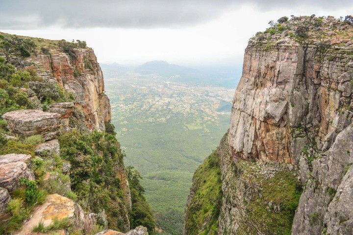
This Angolan section of the escarpment features dizzying, yet beautiful, landscapes. Tundavala Gap, a gouge eroded into the cliff line (below), is one of the most iconic with its well-framed view of the plains below. The precipice also presents a substantial obstacle to transportation. A stretch of the Namibe-Lubango Road overcomes this challenge with a series of scenic hairpin turns climbing to Serra da Leba pass near the town of Leba.
Lubango, one of Angola’s largest cities, occupies a valley on the Huíla plateau. In addition to its remarkable natural surroundings, the city boasts a diverse mix of cultures, striking architecture, and a wide variety of locally produced foods.
NASA Earth Observatory images by Wanmei Liang, using Landsat data from the U.S. Geological Survey, and VIIRS data from NASA EOSDIS LANCE, GIBS/Worldview, the Suomi National Polar-orbiting Partnership, and the Joint Polar Satellite System (JPSS). Photo of Tundavala Gap © jbdodane.com. Story by Lindsey Doermann.
References & Resources
- African Leadership Magazine (2024, May 3) Unveiling Lubango, the Hidden Gem of Southern Angola. Accessed January 5, 2026.
- The American Alpine Journal (2024) Fenda da Tundavala and Serra da Leba, New Routes. Accessed January 5, 2026.
- Atlas Obscura (2025, August 18) Serra da Leba Pass. Accessed January 5, 2026.
- Clark, V.R., et al. (2011) The Great Escarpment of southern Africa: a new frontier for biodiversity exploration. Biodiversity and Conservation, 20, 2543–2561.
- CNN (2023, November 27) Lubango: The spectacular African destination you’ve probably never heard of. Accessed January 5, 2026.
- NASA Earth Observatory (2017, March 13) South Africa’s “Brown Gold.” Accessed January 5, 2026.
- NASA Earth Observatory (2013, December 14) South Africa Tribute. Accessed January 5, 2026.


You may also be interested in:
Stay up-to-date with the latest content from NASA as we explore the universe and discover more about our home planet.

Researchers are using satellites to study development patterns in this fast-growing city in Ethiopia.

Satellites are helping land managers track ecological shifts as reserves reconnect and landscapes return to a more natural state.

Satellites have tracked development over the decades as a small city in southern Nigeria grew to more than 2 million…


