Student teams competed in the 2025 Invention Challenge at NASA’s Jet Propulsion Laboratory on Dec. 5. The event pits middle and high school teams against each other as they try to get handmade devices to accomplish a task.
NASA/JPL-Caltech
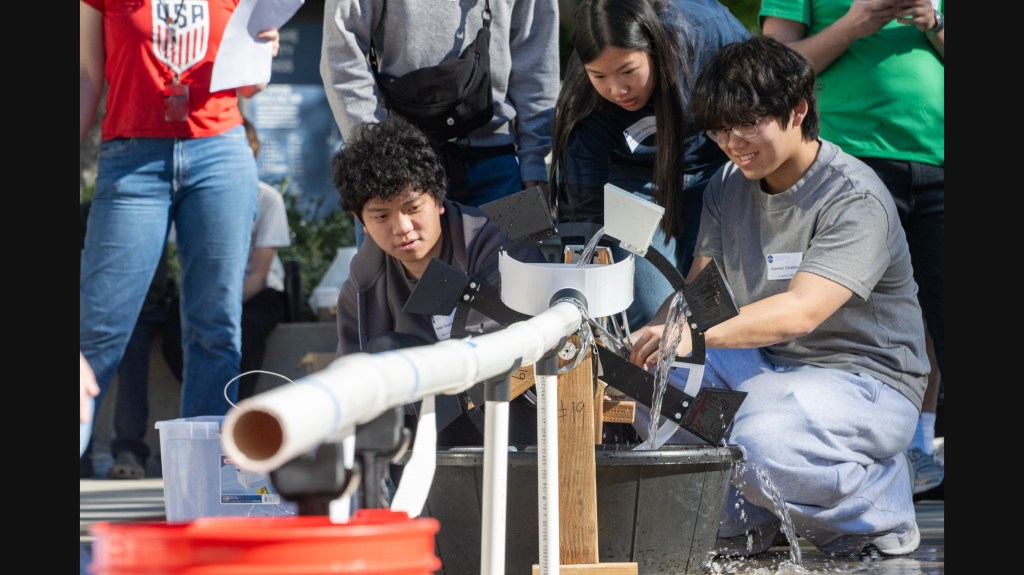
The 2025 Invention Challenge at JPL called on teams to build devices capable of moving about 2 gallons (8 liters) of water from a holding reservoir into a bucket about 16 feet (5 meters) away within 60 seconds.
Teams at JPL’s 2025 Invention Challenge built their devices with plywood, PVC pipe, duct tape, and even soda cans.
NASA/JPL-Caltech
Now in its 26th year, the event brings teams of middle and high school students to the lab to compete with home-built contraptions.
Teenagers wielding power tools and plywood demonstrated their engineering prowess at the annual Invention Challenge at NASA’s Jet Propulsion Laboratory in Southern California on Friday. Also in evidence: lots of small motors, 3D-printed gears, PVC pipe, and duct tape.
First held at JPL in 1998, the event pits middle and high school teams against each other as they try to get handmade devices to accomplish a task that changes annually. For this year’s challenge, dubbed the “Bucket Brigade Contest,” teams needed to create devices capable of moving about 2 gallons (8 liters) of water from a holding reservoir into a bucket about 16 feet (5 meters) away in 60 seconds while satisfying a long list of rules.
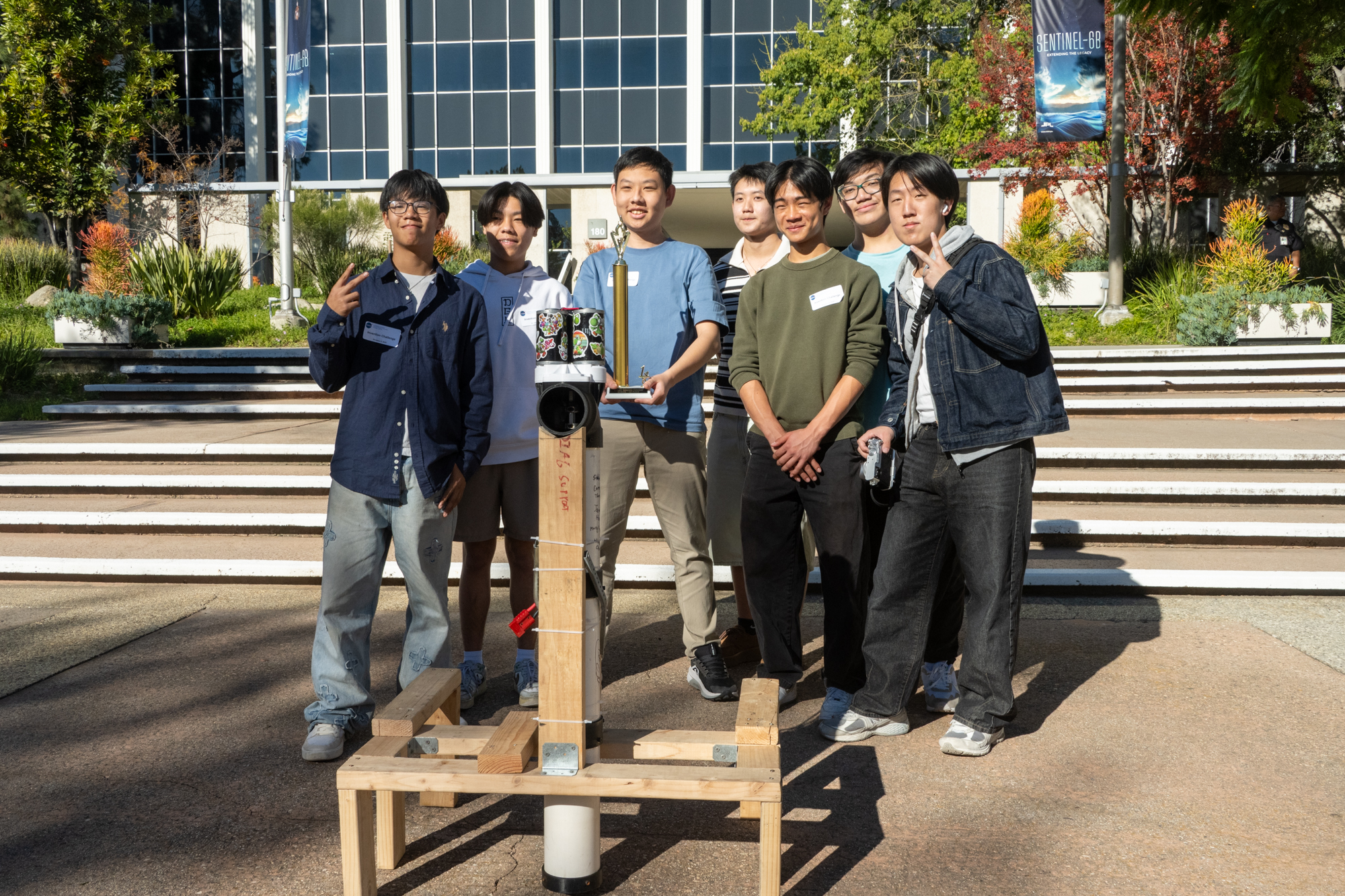
Arcadia High School’s Team Still Water won first place among student teams in the 2025 Invention Challenge at JPL.
NASA/JPL-Caltech
In all, 18 teams of students from middle and high schools across Los Angeles and Orange counties competed. First place went to Arcadia High School’s Team Still Water, which completed the task in just 6.45 seconds. Mission Viejo High’s Team Senior Citizens was close behind, finishing in 6.71 seconds. The Samo Seals of Santa Monica High came in third, at 9.18 seconds.
Five teams from outside the area — four from schools in Colorado and Massachusetts and one involving professional engineers — were invited to compete as well. Of those, the team led by retired JPL engineer Alan DeVault’s Team “Trial and Error Engineering” came in first (a repeat from last year). And “Team 6” from Pioneer Charter School of Science in the Boston area took second place (also a repeat performance from 2024). No team qualified for third place.
Some of the devices in the 2025 Invention Challenge at NASA JPL made a big splash.
NASA/JPL-Caltech
Judges named Team Clankers from Mission Viejo High most artistic, Team 6 from Pioneer Charter School of Science most unusual, and Team Winning Engineering Team (WET) from Temple City High most creative.
The event was supported by dozens of volunteers from JPL staff. JPL Fire Chief Dave Dollarhide, familiar with a bucket brigade, was a guest judge.
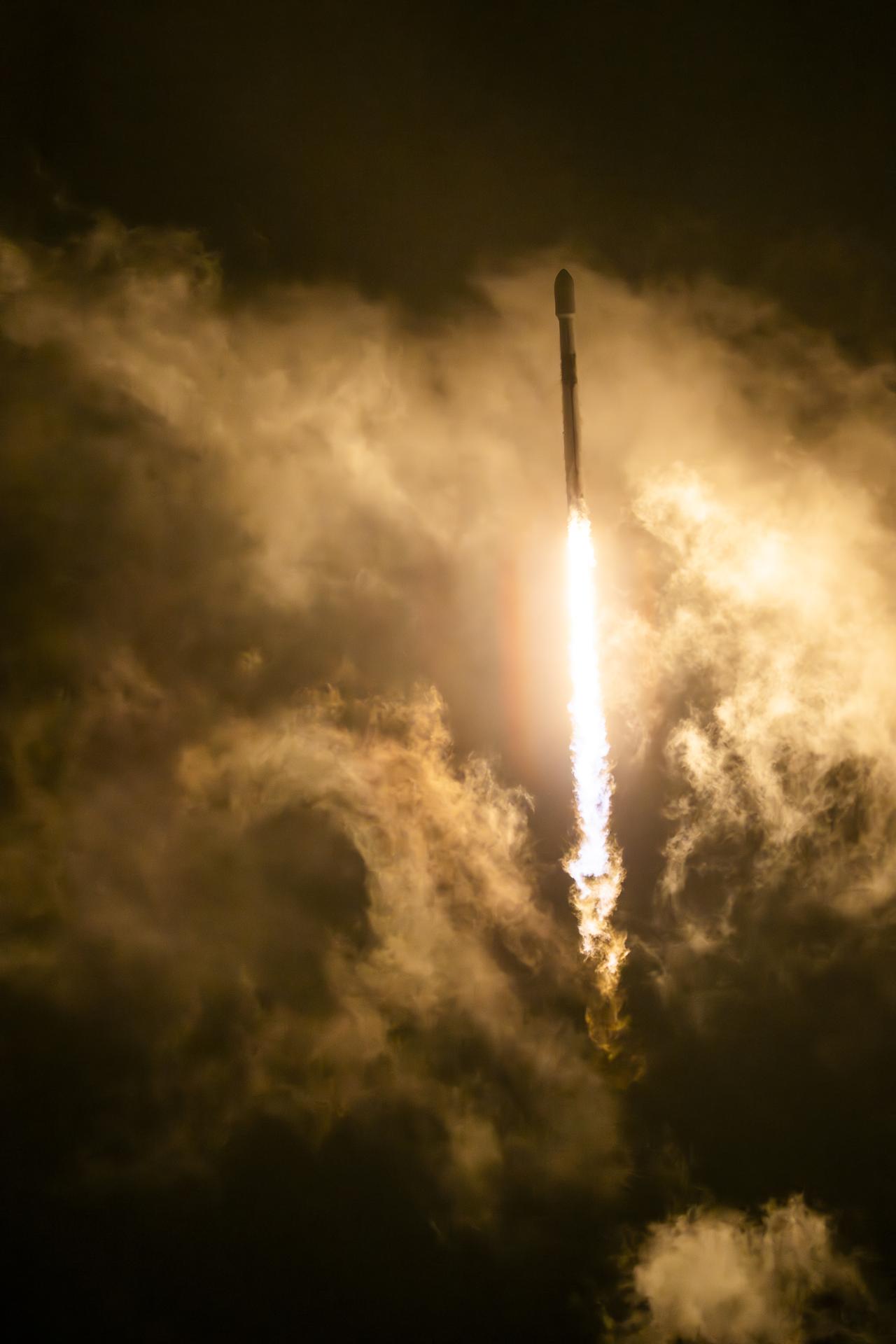
The Sentinel-6B satellite lifted off aboard a SpaceX Falcon 9 rocket from Launch Complex 4 East at Vandenberg Space Force Base in central California at 9:21 p.m. PST on Nov. 16.
Credit: NASA/Carla Thomas
About the size of a full-size pickup truck, a newly launched satellite by NASA and its partners will provide ocean and atmospheric information to improve hurricane forecasts, help protect infrastructure, and benefit commercial activities, such as shipping.
The Sentinel-6B satellite lifted off aboard a SpaceX Falcon 9 rocket from Launch Complex 4 East at Vandenberg Space Force Base in central California at 9:21 p.m. PST on Nov. 16. Contact between the satellite and a ground station in northern Canada occurred about 1 hour and 30 minutes later at 10:54 p.m. All systems are functioning normally.
“Understanding tidal patterns down to the inch is critical in protecting how we use our oceans every day on Earth,” said Nicky Fox, associate administrator, Science Mission Directorate at NASA Headquarters in Washington. “Sentinel-6B will build upon the legacy of Sentinel-6 Michael Freilich by making sea level measurements that improve forecasts used by communities, businesses, and operations across the country. It also will support a safer reentry for our astronauts returning home, including crew from Artemis Moon missions.”
Sea levels vary from place to place, and the satellite will provide accurate measurements at both local and global scales — all from hundreds of miles above in low Earth orbit. Those observations form the basis for U.S. flood predictions, which are crucial for safeguarding coastal infrastructure, real estate, energy storage sites, and other coastal assets. Sentinel-6B will take over for Sentinel-6 Michael Freilich, which launched in 2020 and later became the official reference satellite for global sea level measurements, providing sea surface height measurements against which those from other satellites are compared for accuracy.
The satellite comes from a collaboration between multiple partners, including NASA, ESA (European Space Agency), EUMETSAT (European Organisation for the Exploitation of Meteorological Satellites), and the National Oceanic and Atmospheric Administration (NOAA). It also is part of the European Union’s family of Copernicus missions.
“Collaboration between partners is key to a mission such as Sentinel-6, and my thanks go to everyone involved in developing, launching, and operating this exceptional satellite, which follows in the footsteps of the first Sentinel-6, Michael Freilich,” said Simonetta Cheli, director, ESA’s Earth Observation Programmes. “This achievement demonstrates what can be accomplished when international agencies and industries work together toward a shared goal. Sentinel-6B will ensure we continue to collect the high-precision data needed to understand our changing climate, safeguard our oceans and support decisions that protect coastal communities around the world.”
The two satellites make up the Copernicus Sentinel-6/Jason-CS (Continuity of Service) mission, the latest in a series of ocean-observing radar altimetry missions that have monitored Earth’s changing seas since the early 1990s.
As with its predecessor, Sentinel-6B satellite also will provide key information about wind speeds, wave heights, atmospheric temperature, and humidity. Moreover, because water expands as its temperature increases, researchers can tell which parts of the ocean are warmer than others based on where the sea surface height is greater.
Combined with data from other instruments, that knowledge can help in forecasting marine weather, including the development of hurricanes, which intensify with warmer water. Also, because large currents are taller than surrounding waters due to their higher temperatures, sea surface measurements can shed light on interactions between the Gulf Stream, for example, and nearby waves. Where they meet, seas can become rougher, presenting a hazard to even the largest ships.
“Sentinel-6B is a testament to the value of NASA’s partnership missions to put actionable satellite information and science into the hands of decision-makers on the ground,” said Karen St. Germain, director, NASA Earth Science Division at the agency’s headquarters. “Sentinel-6B will collect ocean surface observations that will inform decisions critical to coastal communities, commercial shipping and fishing, national defense, and emergency preparedness and response. This is what NASA does — puts advanced technology and science into action for the benefit of the nation.”
When Sentinel-6B reaches its operating elevation, the satellite will fly about 30 seconds behind Sentinel-6 Michael Freilich, which carries identical science instruments. Once the mission finishes cross-calibrating the data collected by the two, Sentinel-6 Michael Freilich will move into a different orbit, and Sentinel-6B will take over the role of official reference satellite, orbiting Earth about 13 times a day at 830 miles (1,336 kilometers) above the surface.
“Sentinel-6B demonstrates the versatile Earth science applications made possible by expertly engineered, space-based technology. The satellite’s powerful suite of instruments will measure about 90% of Earth’s oceans down to fractions of an inch — continuing to add to a vital dataset that America and a growing global community depend on,” said Dave Gallagher, director, NASA’s Jet Propulsion Laboratory (JPL) in Southern California.
More about Sentinel-6B
Copernicus Sentinel-6/Jason-CS is a collaboration between ESA, the European Union, EUMETSAT, NASA, and NOAA. French space agency CNES (Centre National d’Études Spatiales) contributed technical support. Copernicus, which includes the Sentinel missions, is the European Union’s Earth observation program led by the European Commission.
A division of Caltech in Pasadena, JPL contributed three science instruments for each Sentinel-6 satellite: the Advanced Microwave Radiometer, the Global Navigation Satellite System – Radio Occultation, and the laser retroreflector array. NASA also is contributing launch services, ground systems supporting operation of the NASA science instruments, the science data processors for two of these instruments, and support for the U.S. members of the international Ocean Surface Topography Science Team, and Sentinel-6 science teams.
In this artist’s concept, the ocean-observing satellite Sentinel-6B orbits Earth with its deployable solar panels extended.
Credit: NASA/JPL-Caltech
NASA will provide live coverage of prelaunch and launch activities for Sentinel-6B, an international mission delivering critical sea level and ocean data to protect coastal infrastructure, improve weather forecasting, and support commercial activities at sea.
Launch is targeted at 12:21 a.m. EST, Monday, Nov. 17 (9:21 p.m. PST, Sunday, Nov. 16) aboard a SpaceX Falcon 9 rocket from Space Launch Complex 4 East at Vandenberg Space Force Base in California.
Watch coverage beginning at 11:30 p.m. EST (8:30 p.m. PST) on NASA+, Amazon Prime, and more. Learn how to watch NASA content through a variety of platforms, including social media.
The Sentinel-6B mission continues a decades-long effort to monitor global sea level and ocean conditions using precise radar measurements from space. Since the early 1990s, satellites launched by NASA and domestic and international partners have collected precise sea level data. The launch of Sentinel-6B will extend this dataset out to nearly four decades.
NASA’s mission coverage is as follows (all times Eastern and subject to change based on real-time operations):
Saturday, Nov. 15
4 p.m. – NASA Prelaunch Teleconference on International Ocean Tracking Mission
Karen St. Germain, director, Earth Science Division, NASA Headquarters in Washington
Pierrik Veuilleumier, Sentinel-6B project manager, ESA (European Space Agency)
Parag Vaze, Sentinel-6B project manager, NASA’s Jet Propulsion Laboratory in Pasadena, California
Tim Dunn, senior launch director, Launch Services Program, NASA’s Kennedy Space Center in Florida
Julianna Scheiman, director, NASA Science Missions, SpaceX
1st Lt. William Harbin, launch weather officer, U.S. Air Force
11:30 p.m. – Launch coverage begins on NASA+, Amazon Prime, and more.
Audio-only coverage
Audio-only of the launch coverage will be carried on the NASA “V” circuits, which may be accessed by dialing 321-867-1220 or -1240. On launch day, “mission audio” countdown activities without NASA+ launch commentary will be carried at 321-867-7135.
NASA website launch coverage
Launch day coverage of the mission will be available on the agency’s website. Coverage will include links to live streaming and blog updates beginning no earlier than 11 p.m. EST, Nov. 16, as the countdown milestones occur. Streaming video and photos of the launch will be accessible on demand shortly after liftoff. Follow countdown coverage on NASA’s Sentinel-6/Jason-CS blog.
For questions about countdown coverage, contact the NASA Kennedy newsroom at: 321-867-2468.
Attend launch virtually
Members of the public can register to attend this launch virtually. NASA’s virtual guest program for this mission includes curated launch resources, notifications about related opportunities or changes, and a stamp for the NASA virtual guest passport following launch.
Watch, engage on social media
Let people know you’re watching the mission on X, Facebook, and Instagram by following and tagging these accounts:
Sentinel-6B is the second of twin satellites in the Copernicus Sentinel-6/Jason-CS (Continuity of Service) mission, a collaboration among NASA, ESA, EUMETSAT (European Organisation for the Exploitation of Meteorological Satellites), and the National Oceanic and Atmospheric Administration (NOAA). The first satellite in the mission, Sentinel-6 Michael Freilich, launched in November 2020. The European Commission contributed funding support, while France’s space agency CNES (Centre National d’Études Spatiales) provided technical expertise. The mission also marks the first international involvement in Copernicus, the European Union’s Earth Observation Programme.
Captured on Aug. 21, this image from NISAR’s L-band radar shows Maine’s Mount Desert Island. Green indicates forest; magenta represents hard or regular surfaces, like bare ground and buildings. The magenta area on the island’s northeast end is the town of Bar Harbor.
Credit: NASA/JPL-Caltech
The NISAR (NASA-ISRO Synthetic Aperture Radar) Earth-observing radar satellite’s first images of our planet’s surface are in, and they offer a glimpse of things to come as the joint mission between NASA and ISRO (Indian Space Research Organisation) approaches full science operations later this year.
“Launched under President Trump in conjunction with India, NISAR’s first images are a testament to what can be achieved when we unite around a shared vision of innovation and discovery,” said acting NASA Administrator Sean Duffy. “This is only the beginning. NASA will continue to build upon the incredible scientific advancements of the past and present as we pursue our goal to maintain our nation’s space dominance through Gold Standard Science.”
Images from the spacecraft, which was launched by ISRO on July 30, display the level of detail with which NISAR scans Earth to provide unique, actionable information to decision-makers in a diverse range of areas, including disaster response, infrastructure monitoring, and agricultural management.
“By understanding how our home planet works, we can produce models and analysis of how other planets in our solar system and beyond work as we prepare to send humanity on an epic journey back to the Moon and onward to Mars,” said NASA Associate Administrator Amit Kshatriya. “The successful capture of these first images from NISAR is a remarkable example of how partnership and collaboration between two nations, on opposite sides of the world, can achieve great things together for the benefit of all.”
On Aug. 21, the satellite’s L-band synthetic aperture radar (SAR) system, which was provided by NASA’s Jet Propulsion Laboratory in Southern California, captured Mount Desert Island on the Maine coast. Dark areas represent water, while green areas are forest, and magenta areas are hard or regular surfaces, such as bare ground and buildings. The L-band radar system can resolve objects as small as 15 feet (5 meters), enabling the image to display narrow waterways cutting across the island, as well as the islets dotting the waters around it.
Then, on Aug. 23, the L-band SAR captured data of a portion of northeastern North Dakota straddling Grand Forks and Walsh counties. The image shows forests and wetlands on the banks of the Forest River passing through the center of the frame from west to east and farmland to the north and south. The dark agricultural plots show fallow fields, while the lighter colors represent the presence of pasture or crops, such as soybean and corn. Circular patterns indicate the use of center-pivot irrigation.
On Aug. 23, NISAR imaged land adjacent to northeastern North Dakota’s Forest River. Light-colored wetlands and forests line the river’s banks, while circular and rectangular plots throughout the image appear in shades that indicate the land may be pasture or cropland with corn or soy.
Credit: NASA/JPL-Caltech
The images demonstrate how the L-band SAR can discern what type of land cover — low-lying vegetation, trees, and human structures — is present in each area. This capability is vital both for monitoring the gain and loss of forest and wetland ecosystems, as well as for tracking the progress of crops through growing seasons around the world.
“These initial images are just a preview of the hard-hitting science that NISAR will produce — data and insights that will enable scientists to study Earth’s changing land and ice surfaces in unprecedented detail while equipping decision-makers to respond to natural disasters and other challenges,” said Nicky Fox, associate administrator, Science Mission Directorate at NASA Headquarters in Washington. “They are also a testament to the years of hard work of hundreds of scientists and engineers from both sides of the world to build an observatory with the most advanced radar system ever launched by NASA and ISRO.”
The L-band system uses a 10-inch (25-centimeter) wavelength that enables its signal to penetrate forest canopies and measure soil moisture and motion of ice surfaces and land down to fractions of an inch, which is a key measurement in understanding how the land surface moves before, during, and after earthquakes, volcanic eruptions, and landslides.
The preliminary L-band images are an example of what the mission team will be able to produce when the science phase begins in November. The satellite was raised into its operational 464-mile (747-kilometer) orbit in mid-September.
The NISAR mission also includes an S-band radar, provided by ISRO’s Space Applications Centre, that uses a 4-inch (10-centimeter) microwave signal that is more sensitive to small vegetation, making it effective at monitoring certain types of agriculture and grassland ecosystems.
The spacecraft is the first to carry both L- and S-band radars. The satellite will monitor Earth’s land and ice surfaces twice every 12 days, collecting data using the spacecraft’s drum-shaped antenna reflector, which measures 39 feet (12 meters) wide — the largest NASA has ever sent into space.
The NISAR mission is a partnership between NASA and ISRO spanning years of technical and programmatic collaboration. The successful launch and deployment of NISAR builds on a strong heritage of cooperation between the United States and India in space.
The Space Applications Centre provided the mission’s S-band SAR. The U R Rao Satellite Centre provided the spacecraft bus. The launch vehicle was provided by Vikram Sarabhai Space Centre, and launch services were through Satish Dhawan Space Centre. Key operations, including boom and radar antenna reflector deployment, are now being executed and monitored by the ISRO Telemetry, Tracking and Command Network’s global system of ground stations.
Managed by Caltech in Pasadena, NASA JPL leads the U.S. component of the project. In addition to the L-band SAR, reflector, and boom, JPL also provided the high-rate communication subsystem for science data, a solid-state data recorder, and payload data subsystem. NASA’s Goddard Space Flight Center in Greenbelt, Maryland, manages the Near Space Network, which receives NISAR’s L-band data.
NASA Data Powers New Tool to Protect Water Supply After Fires
Wildfire-scorched terrain above a water body underscores risks to downstream supplies.
Credits: USFS/Cecilio Ricardo
When wildfires scorch a landscape, the flames are just the beginning. NASA is helping communities across the nation foresee and prepare for what can follow: mudslides, flash flooding, and contaminated surface water supplies.
A new online tool called HydroFlame, built with support from NASA’s Earth Science Division, relies on satellite data, hydrologic modeling, and artificial intelligence to predict how wildfires could affect water resources, from tap water to the rivers and streams where people fish. The project is being developed with the University of Texas at Arlington, Purdue University, the U.S. Geological Survey, and other partners.
For now, the tool includes data only for Montana’s Clark Fork Basin, where it is being piloted. But new applications are underway in California and Utah. Researchers will soon begin fieldwork in Los Angeles County to collect on-the-ground data to refine HydroFlame’s predictive approach — an important step toward expanding it beyond the pilot site.
“As wildfires intensify across the country, so do their ripple effects on regional water resources,” said Erin Urquhart, program manager for NASA’s water resources program at NASA Headquarters in Washington. “HydroFlame could help communities in the U.S. see what’s coming and plan for it, before a fire becomes a water crisis.”
That kind of foresight is exactly what local officials are looking for.
“For someone managing a trout fishery or drinking water supply, knowing when a stream might be overwhelmed with debris after a fire can mean the difference between preparedness and a crisis,” said Morgan Valliant, who is part of the project’s advisory group and the associate director of ecosystem services for Missoula Parks and Recreation in Montana. “This tool could let us move from reacting to planning.”
When fire reshapes land
In the wake of a wildfire, charred hillsides are often unstable. With the protective blanket of plants burned away, rain that once soaked gently into the soil can race downhill, sending ash, debris, and sediment into rivers and reservoirs. That runoff can trigger flash floods and contaminate drinking water.
Severe wildfires can also bake soil into a water-repelling crust. With less absorption, the same slopes can swing from drought to destructive floods, and those runoff risks can persist for decades.
HydroFlame, developed by a team led by Adnan Rajib at the University of Texas at Arlington, is built to anticipate those extremes.
“NASA is constantly pushing the boundaries when it comes to sensing and predicting fire,” Rajib said. “But there is still a huge gap when it comes to translating that fire information in terms of water. That’s where HydroFlame comes in.”
The tool will include three components:
a historical viewer that maps past fire impacts on streamflow and sediment
a “what-if” scenario builder to simulate future fires
a predictive tool that generates weekly forecasts using near-real-time satellite data as initial conditions
When a wildfire is identified, the tool will identify how severely areas are burned across watersheds and track shifts in vegetation, soil wetness, and evapotranspiration, or the release of water from the land and plants to the atmosphere. HydroFlame uses data from satellite missions and instruments including MODIS (Moderate Resolution Imaging Spectroradiometer), Landsat, and SMAP (Soil Moisture Active Passive).
Those observations, combined with stream records from gauged rivers, feed into simulations of possible fire-driven changes in water flow and quality. A machine-learning component will fill in where gauges are absent, making it possible to predict impacts up to two weeks in advance.
This screenshot shows HydroFlame, a NASA-supported online tool that will help U.S. communities better understand and forecast how wildfires may affect water supplies in their region.
A. Rajib
The historical viewer, which is publicly accessible, lets users explore how past fires altered streamflow and sediment levels across the basin. The other components are still in development: The prototype of the “what-if” scenario builder tool is expected to launch in December 2025, with the full version planned for May 2026.
HydroFlame’s ability to capture compounding factors — drought before a fire, flooding afterward — and simulate their cascading effects on water systems is what makes it different from other tools, Rajib said. “Many traditional models treat each fire as a one-off,” he said. “HydroFlame looks at the bigger picture.”
Just as important, the tool is built for people who aren’t experts in satellite data.
“It’s a practical starting point for scenario planning,” said Kelly Luis, associate program manager for NASA’s water resources program and an aquatic ecosystem scientist at NASA’s Jet Propulsion Laboratory in Southern California. The tool’s “what-if” function, she explained, will let water managers, city planners, and other officials apply their local knowledge. For example, they might zero in on the rivers and streams most important to a city’s water supply. “That kind of insight is essential for building solutions that are both scientifically grounded and locally relevant.”
For watershed organizations or local and state agencies with limited staff and resources, that ease of use is crucial — saving time and effort while helping keep costs down.
“These groups need holistic ways to understand potential impacts of fires to their rivers and streams and plan, without always having to bring in someone from the outside,” said Amy Seaman, the executive director of the Montana Watershed Coordination Council. Seaman works with community watershed organizations across Montana and is also part of the project’s advisory group.
This effort is part of a broader NASA focus on understanding how fire reshapes water systems and what that means for American communities.
This false-color Landsat 9 image, acquired Jan. 14, shows burned areas from the 2025 fires in and around Los Angeles, highlighting unburned vegetation (green) and burned land (light to dark brown) using shortwave infrared, near infrared, and visible light. Similar types of NASA fire data are used in HydroFlame.
NASA Earth Observatory
Those predictions turned out to be accurate. In early February, mudflow events struck the areas of Altadena and Sierra Madre in Los Angeles County, following the Eaton Fire. HydroFlame had been run specifically for that fire and flagged both neighborhoods as at risk, Rajib said.
“It wasn’t a formal, data-verified result because we didn’t have ground sensors in place,” Rajib said. “But it was a practical validation. The timing and severity of what we modeled lined up with what occurred.”
Rajib’s team is now working with NASA JPL, the University of California, Merced and Los Angeles County to formally test and expand the tool in the Los Angeles area. The team plans to begin collecting on-the-ground data no earlier than Friday, Sept. 26. That work will include installing stream sensors to measure sediment levels in the county’s streams during California’s rainy season and integrating those data into the tool — a step toward building an early-warning system.
HydroFlame invites those interested in the tool to share their ideas and feedback, and to get involved, through a web form available on the project’s Explore Tools webpage.
Preparations for Next Moonwalk Simulations Underway (and Underwater)
In this infrared photograph, the Optical Communications Telescope Laboratory at JPL’s Table Mountain Facility near Wrightwood, California, beams its eight-laser beacon to the Deep Space Optical Communications flight laser transceiver aboard NASA’s Psyche spacecraft.
NASA/JPL-Caltech
The project has exceeded all of its technical goals after two years, setting up the foundations of high-speed communications for NASA’s future human missions to Mars.
NASA’s Deep Space Optical Communications technology successfully showed that data encoded in lasers could be reliably transmitted, received, and decoded after traveling millions of miles from Earth at distances comparable to Mars. Nearly two years after launching aboard the agency’s Psyche mission in 2023, the technology demonstration recently completed its 65th and final pass, sending a laser signal to Psyche and receiving the return signal, from 218 million miles away.
“NASA is setting America on the path to Mars, and advancing laser communications technologies brings us one step closer to streaming high-definition video and delivering valuable data from the Martian surface faster than ever before,” said acting NASA Administrator Sean Duffy. “Technology unlocks discovery, and we are committed to testing and proving the capabilities needed to enable the Golden Age of exploration.”
This video details how the Deep Space Optical Communications experiment broke records and how the technology demonstration could pave the way for future high-bandwidth data transmission out to Mars distances and beyond. NASA/JPL-Caltech
Record-breaking technology
Just a month after launch, the Deep Space Optical Communications demonstration proved it could send a signal back to Earth it established a link with the optical terminal aboard the Psyche spacecraft.
“NASA Technology tests hardware in the harsh environment of space to understand its limits and prove its capabilities,” said Clayton Turner, associate administrator, Space Technology Mission Directorate at NASA Headquarters in Washington. “Over two years, this technology surpassed our expectations, demonstrating data rates comparable to those of household broadband internet and sending engineering and test data to Earth from record-breaking distances.”
On Dec. 11, 2023, the demonstration achieved a historic first by streaming an ultra-high-definition video to Earth from over 19 million miles away (about 80 times the distance between Earth and the Moon), at the system’s maximum bitrate of 267 megabits per second. The project also surpassed optical communications distance records on Dec. 3, 2024, when it downlinked Psyche data from 307 million miles away (farther than the average distance between Earth and Mars). In total, the experiment’s ground terminals received 13.6 terabits of data from Psyche.
How it works
Managed by NASA’s Jet Propulsion Laboratory (JPL) in Southern California, the experiment consists of a flight laser transceiver mounted on the Psyche spacecraft, along with two ground stations to receive and send data from Earth. A powerful 3-kilowatt uplink laser at JPL’s Table Mountain Facility transmitted a laser beacon to Psyche, helping the transceiver determine where to aim the optical communications laser back to Earth.
Both Psyche and Earth are moving through space at tremendous speeds, and they are so distant from each other that the laser signal — which travels at the speed of light — can take several minutes to reach its destination. By using the precise pointing required from the ground and flight laser transmitters to close the communication link, teams at NASA proved that optical communications can be done to support future missions throughout the solar system.
Another element of the experiment included detecting and decoding a faint signal after the laser traveled millions of miles. The project enlisted a 200-inch telescope at Caltech’s Palomar Observatory in San Diego County as its primary downlink station, which provided enough light-collecting area to collect the faintest photons. Those photons were then directed to a high-efficiency detector array at the observatory, where the information encoded in the photons could be processed.
“We faced many challenges, from weather events that shuttered our ground stations to wildfires in Southern California that impacted our team members,” said Abi Biswas, Deep Space Optical Communications project technologist and supervisor at JPL. “But we persevered, and I am proud that our team embraced the weekly routine of optically transmitting and receiving data from Psyche. We constantly improved performance and added capabilities to get used to this novel kind of deep space communication, stretching the technology to its limits.”
Brilliant new era
In another test, data was downlinked to an experimental radio frequency-optical “hybrid” antenna at the Deep Space Network’s Goldstone complex near Barstow, California. The antenna was retrofitted with an array of seven mirrors, totaling 3 feet in diameter, enabling the antenna to receive radio frequency and optical signals from Psyche simultaneously.
The project also used Caltech’s Palomar Observatory and a smaller 1-meter telescope at Table Mountain to receive the same signal from Psyche. Known as “arraying,” this is commonly done with radio antennas to better receive weak signals and build redundancy into the system.
“As space exploration continues to evolve, so do our data transfer needs,” said Kevin Coggins, deputy associate administrator, NASA’s SCaN (Space Communications and Navigation) program at the agency’s headquarters. “Future space missions will require astronauts to send high-resolution images and instrument data from the Moon and Mars back to Earth. Bolstering our capabilities of traditional radio frequency communications with the power and benefits of optical communications will allow NASA to meet these new requirements.”
This demonstration is the latest in a series of optical communication experiments funded by the Space Technology Mission Directorate’s Technology Demonstration Missions Program managed at NASA’s Marshall Space Flight Center in Huntsville, Alabama, and the agency’s SCaN program within the Space Operations Mission Directorate. The Psyche mission is led by Arizona State University. Lindy Elkins-Tanton of the University of California, Berkeley is the principal investigator. NASA JPL, managed by Caltech in Pasadena, California, is responsible for the mission’s overall management.
To learn more about the laser communications demo, visit:
NASA’s Deep Space Optical Communications (DSOC) technology demonstration has successfully concluded after two years, surpassing all technical goals and pavin...
Preparations for Next Moonwalk Simulations Underway (and Underwater)
It’s been 30 years since the discovery of the first planet around another star like our Sun. With every new discovery, scientists move closer to answering whether there are other planets like Earth that could host life as we know it. NASA/JPL-Caltech
The milestone highlights the accelerating rate of discoveries, just over three decades since the first exoplanets were found.
The official number of exoplanets — planets outside our solar system — tracked by NASA has reached 6,000. Confirmed planets are added to the count on a rolling basis by scientists from around the world, so no single planet is considered the 6,000th entry. The number is monitored by NASA’s Exoplanet Science Institute (NExScI), based at Caltech’s IPAC in Pasadena, California. There are more than 8,000 additional candidate planets awaiting confirmation, with NASA leading the world in searching for life in the universe.
“This milestone represents decades of cosmic exploration driven by NASA space telescopes — exploration that has completely changed the way humanity views the night sky,” said Shawn Domagal-Goldman, acting director, Astrophysics Division, NASA Headquarters in Washington. “Step by step, from discovery to characterization, NASA missions have built the foundation to answering a fundamental question: Are we alone? Now, with our upcoming Nancy Grace Roman Space Telescope and Habitable Worlds Observatory, America will lead the next giant leap — studying worlds like our own around stars like our Sun. This is American ingenuity, and a promise of discovery that unites us all.”
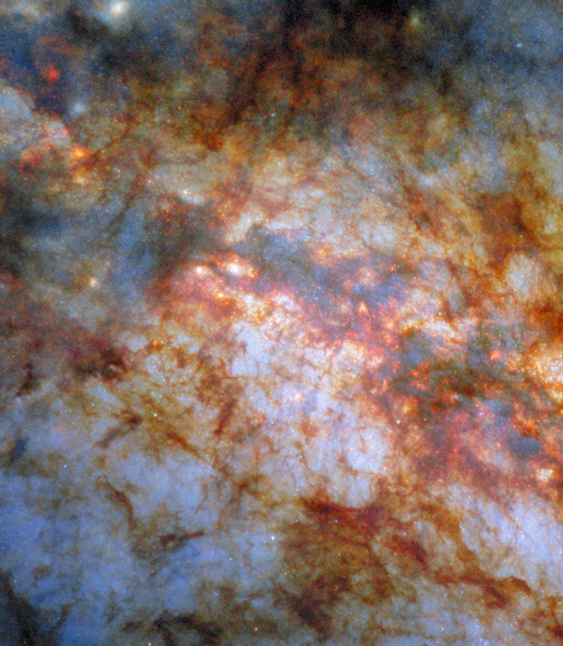
Scientists have found thousands of exoplanets (planets outside our solar system) throughout the galaxy. Most can be studied only indirectly, but scientists know they vary widely, as depicted in this artist’s concept, from small, rocky worlds and gas giants to water-rich planets and those as hot as stars.
NASA’s Goddard Space Flight Center
The milestone comes 30 years after the first exoplanet was discovered around a star similar to our Sun, in 1995. (Prior to that, a few planets had been identified around stars that had burned all their fuel and collapsed.) Although researchers think there are billions of planets in the Milky Way galaxy, finding them remains a challenge. In addition to discovering many individual planets with fascinating characteristics as the total number of known exoplanets climbs, scientists are able to see how the general planet population compares to the planets of our own solar system.
For example, while our solar system hosts an equal number of rocky and giant planets, rocky planets appear to be more common in the universe. Researchers have also found a range of planets entirely different from those in our solar system. There are Jupiter-size planets that orbit closer to their parent star than Mercury orbits the Sun; planets that orbit two stars, no stars, and dead stars; planets covered in lava; some with the density of Styrofoam; and others with clouds made of gemstones.
“Each of the different types of planets we discover gives us information about the conditions under which planets can form and, ultimately, how common planets like Earth might be, and where we should be looking for them,” said Dawn Gelino, head of NASA’s Exoplanet Exploration Program (ExEP), located at the agency’s Jet Propulsion Laboratory in Southern California. “If we want to find out if we’re alone in the universe, all of this knowledge is essential.”
Searching for other worlds
Fewer than 100 exoplanets have been directly imaged, because most planets are so faint they get lost in the light from their parent star. The other four methods of planet detection are indirect. With the transit method, for instance, astronomers look for a star to dim for a short period as an orbiting planet passes in front of it.
To account for the possibility that something other than an exoplanet is responsible for a particular signal, most exoplanet candidates must be confirmed by follow-up observations, often using an additional telescope, and that takes time. That’s why there is a long list of candidates in the NASA Exoplanet Archive (hosted by NExScI) waiting to be confirmed.
“We really need the whole community working together if we want to maximize our investments in these missions that are churning out exoplanets candidates,” said Aurora Kesseli, the deputy science lead for the NASA Exoplanet Archive at IPAC. “A big part of what we do at NExScI is build tools that help the community go out and turn candidate planets into confirmed planets.”
The rate of exoplanet discoveries has accelerated in recent years (the database reached 5,000 confirmed exoplanets just three years ago), and this trend seems likely to continue. Kesseli and her colleagues anticipate receiving thousands of additional exoplanet candidates from the ESA (European Space Agency) Gaia mission, which finds planets through a technique called astrometry, and NASA’s upcoming Nancy Grace Roman Space Telescope, which will discover thousands of new exoplanets primarily through a technique called gravitational microlensing.
Many telescopes contribute to the search for and study of exoplanets, including some in space (artists concepts shown here) and on the ground. Doing the work are organizations around the world, including ESA (European Space Agency), CSA (Canadian Space Agency), and NSF (National Science Foundation).
NASA/JPL-Caltech
Future exoplanets
At NASA, the future of exoplanet science will emphasize finding rocky planets similar to Earth and studying their atmospheres for biosignatures — any characteristic, element, molecule, substance, or feature that can be used as evidence of past or present life. NASA’s James Webb Space Telescope has already analyzed the chemistry of over 100 exoplanet atmospheres.
But studying the atmospheres of planets the size and temperature of Earth will require new technology. Specifically, scientists need better tools to block the glare of the star a planet orbits. And in the case of an Earth-like planet, the glare would be significant: The Sun is about 10 billion times brighter than Earth — which would be more than enough to drown out our home planet’s light if viewed by a distant observer.
NASA has two main initiatives to try overcoming this hurdle. The Roman telescope will carry a technology demonstration instrument called the Roman Coronagraph that will test new technologies for blocking starlight and making faint planets visible. At its peak performance, the coronagraph should be able to directly image a planet the size and temperature of Jupiter orbiting a star like our Sun, and at a similar distance from that star. With its microlensing survey and coronagraphic observations, Roman will reveal new details about the diversity of planetary systems, showing how common solar systems like our own may be across the galaxy.
Additional advances in coronagraph technology will be needed to build a coronagraph that can detect a planet like Earth. NASA is working on a concept for such a mission, currently named the Habitable Worlds Observatory.
More about ExEP, NExScI
NASA’s Exoplanet Exploration Program is responsible for implementing the agency’s plans for the discovery and understanding of planetary systems around nearby stars. It acts as a focal point for exoplanet science and technology and integrates cohesive strategies for future discoveries. The science operations and analysis center for ExEP is NExScI, based at IPAC, a science and data center for astrophysics and planetary science at Caltech. JPL is managed by Caltech for NASA.
The official number of exoplanets, planets outside our solar system, confirmed by NASA has reached 6,000.Thirty years ago, the first exoplanet was discovered a...